With the welter of contradictory information regarding the location of the EV490 crash site as reviewed above, what follows is a blow-by-blow recounting of finding of the actual crash site.
This map seems to have first appeared in 2Bangkok.com Forum 3874-Bandara-Bridge-History in an entry by Wisarut Bholsithi 1828 24 Feb 2010:
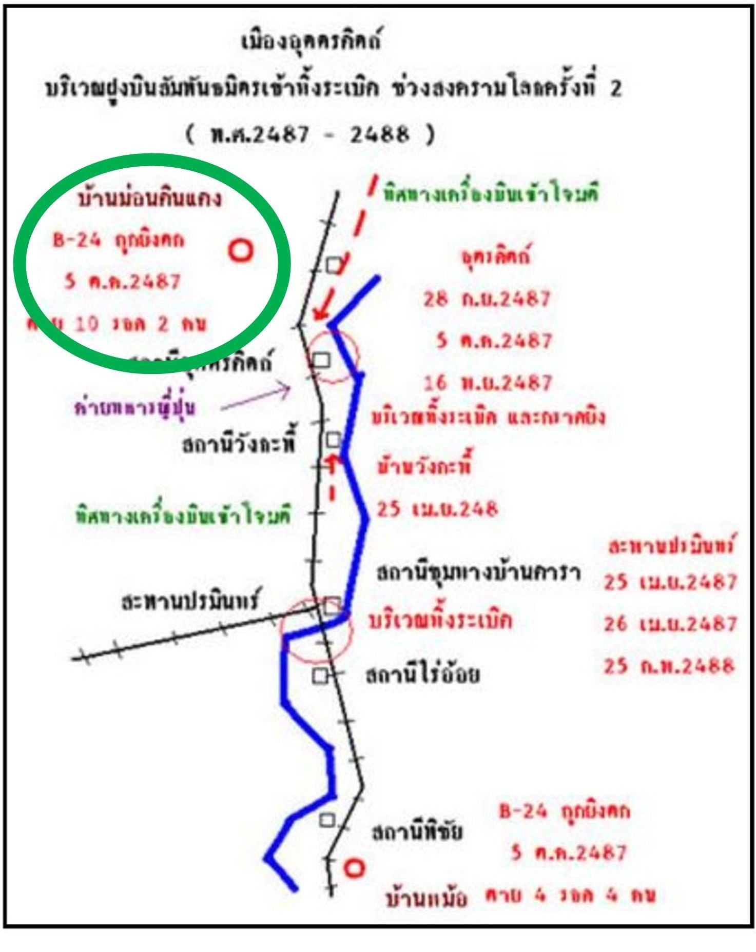
It was subsequently lost when the 2Bangkok website was hacked and destroyed. However, the map had been preserved in a 2013 blog by “Konsilaat” in บ้านเกศวุฒิ 11 (but since dropped) and was brought to my attention by Ben Svasti.2 While the source of the map is not now known,3 it is significant because it gives a name for the location of the crash of a B-24 to the north of Uttaradit, Ban Mon Din Daeng, in which two crew members survived (circled):
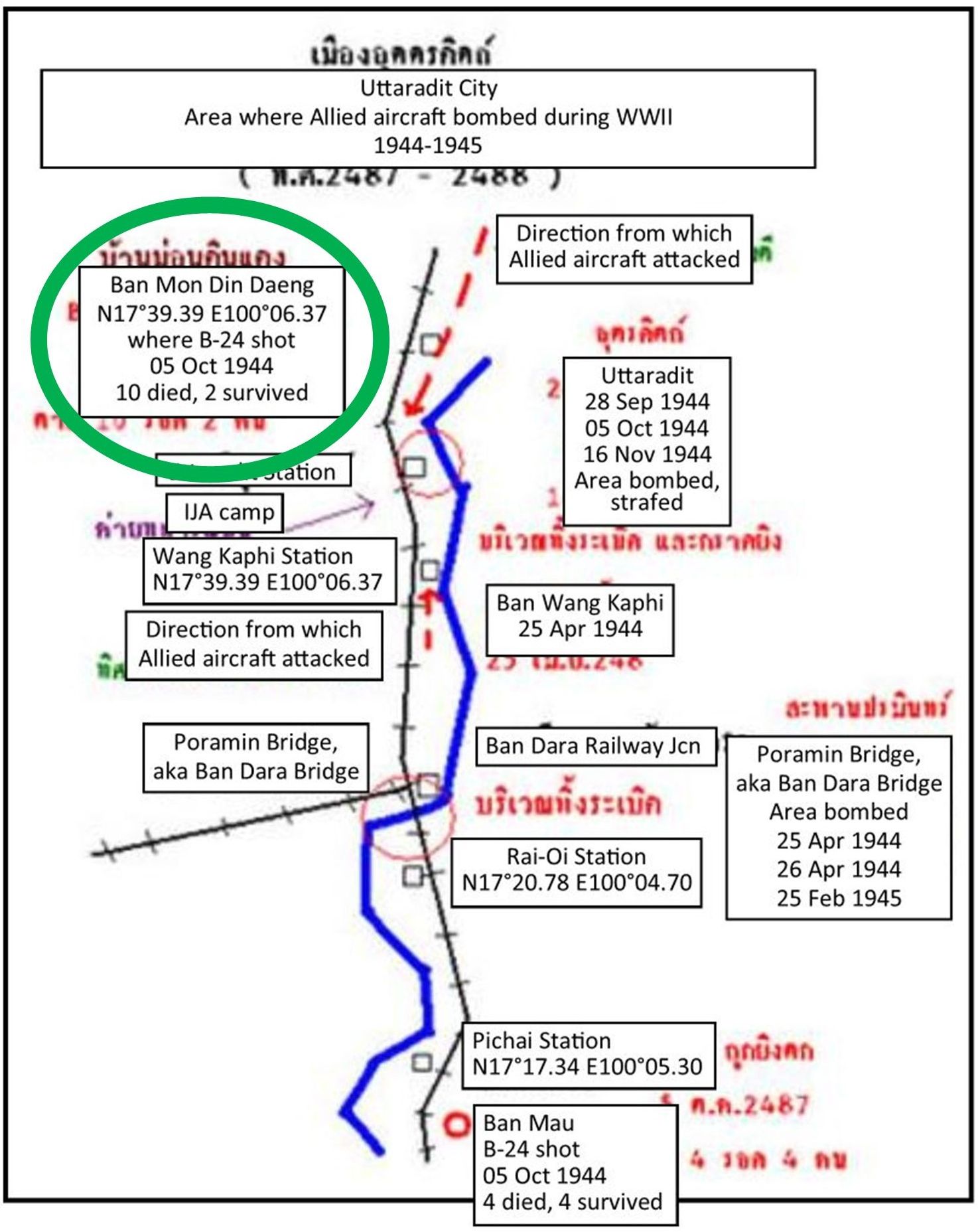
Coordinates are approximate and were added for guidance in the field. In a concurrent email exchange, Matt Poole4 pointed out that the National Archive of Australia located the EV940 crash site to the north of Uttaradit. Near the end of April 2022, I googled “B-24 Mon Din Daeng” in Thai and found this information on the หมู่บ้านคุ้งตะเภา (offsite link) for Khung Taphao Village) website,5 the key parts of which translate as:
The village of Khung Taphao was not greatly affected by World War II except in Oct 1944, when a B-24 bomber, hit during an attack on the railway running through Uttaradit, crashed in the area of Mon Din Daeng. Villagers subsequently collected pieces of the plane. One piece of the B-24 wing was fashioned into a container now on display at the Wat Khung Taphao Local Museum.
Ben subsequently issued a Facebook social media post to people living in the area asking for information about an airplane crash:
RAF B-24 EV940 6km radius around Nong Din Daeng
His results [Ben email 03-Jun-22, 09:28]:
Initial feedback is that plane crashed at Village 10, Tha Sao Sub-District หมู่สิบตำบลท่าเสาอำเภอเมืองจังหวัดอุตรดิตถ์ in an area which later became office for a forest concession belonging to Sia Oo or Khun Sunan Seehalak (four times city mayor Uttaradit) next to the army village. Possibly near the Tha Sao sawmill (Google Maps link)
In any case you can check with the village headman for Mu 10 at this location (Google Maps link).
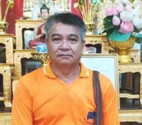 On Sunday, 26 Jun 2022, we visited the Wat Khung Taphao Museum (wat compound entrance6 Google Maps link), located in the wat’s wihan on the second floor off to the right (east) side. We were met by 56 year-old Somchai Sampaotong,7 the local headman, or Puyahban, who is in charge of the museum collection.
Extremely hospitable / cooperative, but unfamiliar with the “container” we wanted to see, he checked with the abbot who told him where to find it in the storeroom below the wat. He produced an extremely dusty, cobweb shrouded specimen, complete with an abandoned wasp nest — a container fashioned from aluminum in the EV940 wing:
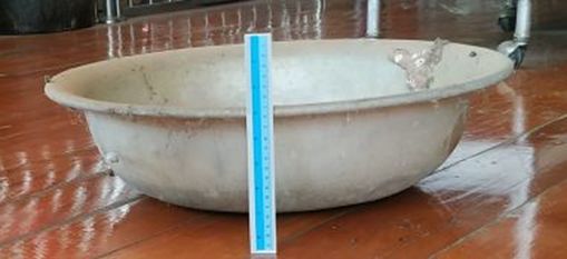
Outside diameter: 58 cm
Base diameter: 15 cm
Height: 28 cm
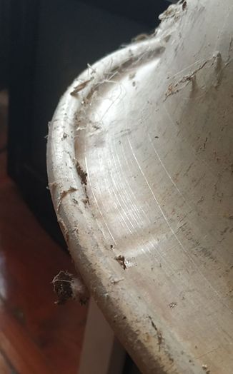 Obviously made of aluminum, it appeared to me to be too perfectly formed to have been the product of a manual peening process: it was more likely the product of a machine shop. There are concentric rings in the exterior curved surface which tend to suggest the surface of a machined die. However, the lip of the container does show numerous peening marks indicating the lip was given final touches manually. The piece is heavy, not made of the same type of soft aluminum used in present day cookware:
Whether or not genuine, the description / identification of the container, as made from the aluminum wing of a B-24, suggests that the plane, or a plane, had crashed in the area.
On Monday, 27 Jun 2022, the first business day of the week, we targeted the Tambon Tha Sao offices on our Garmin. There, asking where there might be elderly people knowing about the crash, we were directed to the headman of Moo 10 (which dovetailed nicely with Ben’s information as to a probable source of information).
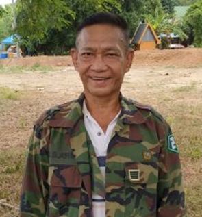
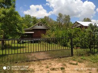
The headman was 54-year-old Bpragim Yagongko8. With him, we were lucky: his grandfather had been the chief of police in the village at the time of the crash. In his picture, Bpragim wears an army uniform jacket, a carryover from his time in the RTA. His house is about 0.4 km WSW of the crash site. He led us to the crash site, located, ironically, in a former cemetery, on private land behind this gate9, at the left of the photo:
The former cemetery status may be evidenced by this Google Earth view of Jan 2015; slender yellow arrows point at possible white grave markers:
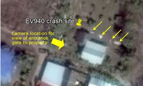
The monuments(?) do not appear in later dated Google Earth views. Note that the grave markers are unrelated to the EV940 crash victims and only confirm the location of a more recent cemetery. Again, dovetailing with Ben’s information, the crash site was found to be located almost adjacent to a private housing development catering to army veterans.
Remains of the nine crew members who died in the crash were recovered after the war and buried in Kanchanaburi War Cemetery. The two parachuting from the stricken plane were captured, imprisoned in Bangkok, and released at the end of the war. Bpragim believes that the two had initially been hidden by Thai authorities behind the Uttaradit Hospital.
EwenS in ww2aircraft.net suggests that the description of EV940 steepening its climb to 90° indicates that the pilot might well have been killed when the plane was first hit by ground fire and the plane was thereafter out of control (see EwenS critique at forum subject, “B-24 performance, tactics”).
Last Updated on 26 February 2026
- at < http://www.oknation.net/blog/sonorwut/2013/07/16/entry-3 >[↩]
- email of 1712 24 Mar 2022[↩]
- Wisarut Bholsithi, 5-Mar-22, 05:43[↩]
- email of 0309 20 Mar 2022[↩]
- my ref: Hak email 29-Apr-22, 16:54[↩]
- N17°39.22 E100°08.43[↩]
- residence: 153/1 Moo 4 Tambon Khung-Taphao, Amphoe Meung, Uttaradit[↩]
- residence and office: 44 Moo 10, Tambon Tha Sao, Amphoe Meung, Uttaradit (N17°39.898 E100°5.725), Tel 086 212 9078[↩]
- gate at N17°39.997 E100°05.953[↩]