Khun Yuam Airstrip and air activities in the area
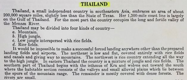
1941: The airstrip at Khun Yuam (Google Maps link)1 has recently been thought to have been a product of WW2. However, it had to have been constructed prior to June 1942 since it was included in a US government publication of that date and the US had lost access to the country on 08 Dec 1941, seven months before:2
It is also listed in that reference with the title:3
![]()
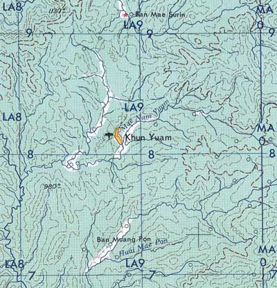
To have been recorded as in existence that soon after the war started suggests that it existed prior to the start of the war — almost certainly as a part of the commercial air network built by Thailand’s Aerial Transport Company to handle both mail and passengers. However, as noted, it apparently did not exist much before the start of WWII for it is not mentioned in air facility records through 1941. Further, an Allied intelligence report on Thai air capabilities in 1940 which lists existing and planned airmail distribution points,4 does not include the location. Nor is the airstrip mentioned in official Royal Thai Air Force histories. Air routes in the northwest of Thailand in 1941 are summarized below (the empty area circled in red denotes the location of Khun Yuam):5
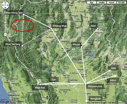
Closeup of Khun Yuam Airstrip location6

ORIGINS: The justification for the Khun Yuam Emergency Airfield could lie in the sentence below: “It would be impossible to make a successful forced landing anywhere other than the prepared landing fields and airports”:7
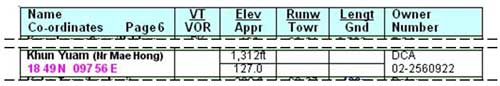
1942: Listing with information presumably collected before June 1942 is as shown at top of page. Note that no details are provided — no location, dimensions, surface, facilities.
1943: The official Japanese military history of WWII8 does record that, in preparation for the IJA 1944 invasion of India, a vehicle road was to be established connecting the railhead in Chiang Mai, Thailand (Google Maps link), with the road, river, and rail9 junction in Toungoo, Burma (Google Maps link). That road was to pass through the border town of Khun Yuam in Thailand.
The following IJA units were assigned to build the road:10
. . . the IJA 15th Division’s [140th] Engineering Regiment and one Infantry Battalion, as well as the main force of the Independent 23rd Engineering Regiment around 01 August 194311 . . . .
They were given two months to complete the work. As the Japanese military history notes:
. . . the two month schedule for the project imposed by the Southern Army Group for improving over 400 kilometers [of caravan trails and footpaths sufficiently to handle motorized vehicles] was wholly unrealistic.12 . . . the entire length of the road was around 300 km in a straight line, with the length of construction exceeding 400 km.13 In addition, the terrain was very rugged, and continually being modified by downpours [and accompanying erosion]. . . .14
November 1943: Thus, when it became obvious that the time required for the road improvement project has been grossly underestimated, the effort was largely abandoned on 09 Nov 1943, three months after the order had been given, and most of the IJA units assigned to the work were sent on to Burma via the Lampang-Kengtung Road.15
Ironically, even though the IJA abandoned the Chiang Mai-Toungoo road project in November 1943, in that same month, Allied intelligence began paying attention to the air facility at Khun Yuam:16
To be strictly accurate, Airfield Reports with issue No. 16 (Nov 1943) changed format and became much more comprehensive than previous reports. Report Nos. 14 and 15 (the only previous ones currently available), do not mention Khun Yuam. The wording in Report No. 16 clearly implies that the Khun Yuam airstrip had not been previously recorded with aerial photography.))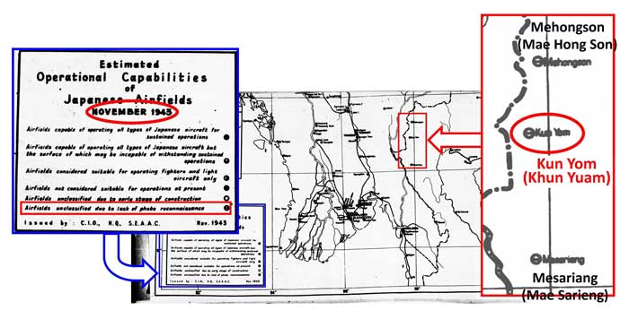
April 1944: An Allied intelligence report offered this amplification:17

Individual paragraphs within Allied published intelligence reports sometimes included dates when actual observations were made. In this case, unfortunately, the observation can only be keyed to the more general date of the Airfield Report, ie, here, No 21, April 1944. It can be assumed however that the “photographic cover” actually occurred in November 1943, or before, as evidenced by the dated map in the previous entry just above.
Some details provided in the description do not conform well to the actual situation at Khun Yuam.
- . . . location is about 1 1/2 miles northeast of a village, possibly Khun Yuam . . . : another unfortunate aspect here — the aerial photos are not available to verify the text. There is a village about that distance southwest of the airstrip: Ban To Phae, and it was shown as very sparsely built up in RTSD map 4546 I, dated 1992, the earliest map available. However, curiously, the airstrip is directly across the main north-south road from the largest wat complex in Khun Yuam, around which houses were shown grouped in that same map. There is no comparable grouping of structures in the area.
- . . . between a road and a tortuous river. . . : the airstrip is actually located west of both the main north-south road (now Rte 108) and the Yuam River. The road actually touches the northeast corner of the airstrip before wandering southeasterly to eventually cross the tortuously twisting and turning Yuam River as it turns west.
- Jariya Upara, a guard at the WWII Japanese Army Museum (now the Thai Japanese Friendship Memorial Hall) in Khun Yuam, recalled in an interview:
- The route that the Japanese soldiers used to get from Burma to Khun Yuam is one that they had cut themselves. It was clear enough to travel, but only with difficulty. But, in actual fact, it was an old trade route incorporated by the IJA into its way to Toungoo.
- . . . . They didn’t just build a road; they also made a temporary airstrip here. You can still see the remnants of it. But the airstrip existed at the beginning of the war.
I was 12 years’ old then, and can remember it all clearly. . . .18
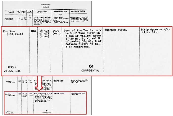
July 1944: More details were provided, including classification of the Khun Yuam runway as an “ELG”, or Emergency Landing Ground. It was, however, described as “u/s”, unserviceable :19
December 1944: In the Allied intel report, Khun Yuam is presented as equal in prominence to Mae Hong Son — at least in font size:20

20 March 1945: A commercial Thai mail plane attacked by an American P-51 crashed near Mae Surin (Google Maps link)21, about 9 km north of Khun Yuam.
While no activity was ever reported at the airstrip by Allied intelligence, the airstrip served a utilitarian function before the end of the war, if a Mr Boon-ton Sriwichai’s recollections in a 1998 interview are correct:
. . . there was a [Thai] mail plane (for letter delivery from Mae Hong Son to Amphoes Khun Yuam and Mae Sariang). This plane flew three times a month.22
April 1945: A more formal intel report write up on Khun Yuam appeared:23

The formality of the report’s appearance may well have been a function not of the perceived growing importance of the Khun Yuam ELG, but rather of the growing sophistication of an expanding Allied intelligence organization.
No further reports on Khun Yuam have been found. As of March 2025, no World War II era aerial photographs of the Khun Yuam area have been released to support these Allied intelligence reports.
For the record, it should be noted that the seminal five-volume British history, The War Against Japan, confused the airstrip’s legacy by wrongly stating that it was built after the war (emphasis added):
Throughout January [1946] . . . along the Toungoo-Mawchi-Kemapyu-Chiengmei (Siam) road, demolitions were carried out . . . [by] the [British Indian Army] . . . . This advance through the Karen Hills into Siam led to discoveries that there were unsurrendered Japanese in north-west Siam . . . The Japanese were ordered to concentrate at Khum Yuam, on the road some twenty miles inside Siam, where they were employed in making an airstrip and disarmed before being marched back to Toungoo.24
It might have been correct if the italicized words instead read:
. . . where they were employed in repairing an existing airstrip . . . .
While Allied intelligence is well recorded as having known of the Khun Yuam airstrip during the war, Kirby’s work apparently lost that particular bit of comparative trivia midst the myriad of detail it did admirably cover.
There is an ancillary issue here: why the Allies did not find the IJA troops in the Khun Yuam area until January 1946. Ironically, a Melbourne newspaper published a retrospective article on 13 October 1945 with the subtitle, “The Road Over Which the Japanese Tried to Escape Into Siam is Picturesque and Populous”, referring to the road from Toungoo to Thailand. Perhaps it is not ironic if one assumes that at the time of publication, the Japanese were believed only to have “tried” to escape to Siam — they had not succeeded, but then, of course, they were later found to have succeeded.25
To compound the error by The War in Japan, a local interview presented on the Internet with a Thai eye-witness, Jarun Chaopurayun, recorded:
Q: Are the remnants of an airstrip near the [WWII War] museum [at Khun Yuam] from an airstrip that the Japanese army used?
A: No. That was actually made by the Allies after the end of the war. When the British army first came, my father went to Don Muang to greet them. The assistant director, Mr Thum (トゥーム) gave him the duty of coordinating with the British. Mr Thum’s last name was Chaba (チャビヤー) . . .
Q: So that airstrip was not built for the Japanese army to use, but was built by the Japanese army for the British army?
A: That’s right, it was built to send off the Japanese army.26
It would appear that Jarun either forgot or never saw the work that originally installed the runway.
Some reasons for restoration of the airstrip were later recalled:
Officers told us that English planes came to carry Japanese engineers to fix bridges and important buildings in Myanmar. There were three or four flights each day. The plane was small carrying only three passengers including the pilot. The passengers took tools with them.
A plane with English markings from Burma had a foreign [British?] pilot. I have heard that the officers in the district office and the police station had contacted Japanese engineers so British soldiers could take them out by plane.27
The plane carried sick people and important people to Toungoo.28
1957: Khun Yuam airstrip appeared in the US Army Corps of Engineers map of the area in 1957:29
February 1971: Khun Yuam was carried in Air America listings in 1971:30

1975: It then appeared in Defense Mapping Agency map:31

1983: Khun Yuam airstrip continues in listings today. The last Tactical Pilot Chart (TPC) covering the area was issued in 1983, and it showed an air facility at Khun Yuam. That map / chart itself has not been reissued since 1983:32

2008: Heber privately published an update of sections of the TPC in 2008. The key change is the status “Closed”:33

(FIS) Fantacia in the upper left box refers to “Flight Information Service Designation ‘Fantacia'34
2010: Thailand’s Sport Pilot Guide was last updated in October 2010, and lists Khun Yuam, though with many essential operational details missing:35
25 June 2012: Since many changes have, of course, occurred since the TPC was last issued in 1983, those changes have been communicated via standard “Notices to Airmen” (NOTAMs).36 The last for Khun Yuam was:37
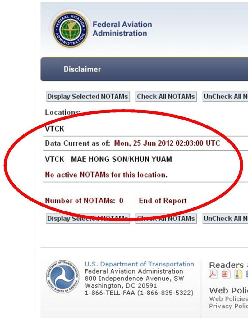
Note that Khun Yuam is here grouped with Mae Hong Son — the nearest active air facility in the area.
The Thai Flying Club has a Khun Yuam Airport (offsite link) webpage, but it does not present much useful information, probably because the facility is unused and unusable. The page does, however, feature an excellent oblique photo of the site; unfortunately, it is mislabeled: rather than looking south per the Club comment, it is actually looking north.38
As the Thai Flying Club photo demonstrates, however, Khun Yuam is still very visible from the air. Google Earth offers this view:39
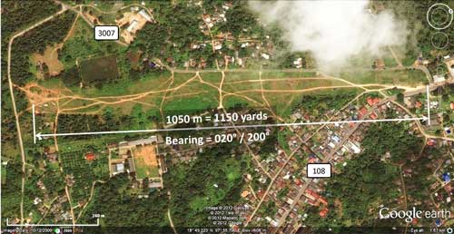
The old runway can be traced from the now well-beaten paths wandering over it. The apparent bearing, 020°/200° (02-20), and length, 1150 yards, shown above, compare well with Allied intelligence report data: “NNE-SSW” (22.5°) and “1,100 yards approx”. The location cited in the intel report is about 6 km SSW of the actual location; but navigation accuracy back then was limited by the occasional use of a sextant with dead reckoning sufficing between sightings.
| 0 | First published on Internet | |
| 1 | Minor editing of text. Recent history added at end. | |
| 2 | Reorganized closer to chrono order; smoothed: added Mawchi article, interviews pro & con on airfield start, & Appendix | |
| 3 | Converted to WordPress by Ally Taylor | |
| 4 | Updated, author errors & typos corrected | |
Last Updated on 11 December 2025
- N18°49.316 E97°55.791 Google Earth: center of runway.[↩]
- Airport Directory: South East Asia (Burma, French Indo-China, Malaya, Thailand) (Washington: Air Movements Section, AFDIS, USAAF, 28 June 1942), p 15 [hereafter Airport Directory 1942]; my ref: 03400 USFE Cmd Documentation\_Airfields List (Sak)\1942 Originals\19420628-08.jpg

Its Type “E” is defined as “Emergency fields (Military or Civil) either of small size or having few facilities or both”.((Ibid, p v.[↩]
- Ibid, p xvi.[↩]
- 戦史叢書 : Vol 15: インパール作戦―ビルマの防衛 (東京: 防衛庁防衛研修所戦史室 (編集), 1968年) [Senshi Sosho, v 15, Imphal maneuvers – Burmese defense (Tokyo: Asagumo, 1968) (hereafter Senshi Sosho)], p 140[↩]
- The map is a composite of information from Young, Edward, Aerial Nationalism (Washington: Smithsonian Institute, 1995), p ix, and A Survey of Thailand (Siam), (Washington: US War Department, March 15, 1941) p 101, “Civil Air Routes (Jan 1940)”, (USAF Archive Reel B1750, p1811), superimposed on a “Terrain” map from Nations Online Project: Searchable Map and Satellite View of Thailand using Google Earth Data, no longer on-line. Annotations by author using Microsoft Publisher show solid white lines per Young and lines unique to US War Department as dashed.[↩]
- “Terrain” map from Nations Online Project: Searchable Map and Satellite View of Thailand using Google Earth Data, no longer on-line. Annotations by author using Microsoft Publisher.[↩]
- Airport Directory 1942, p III[↩]
- 戦史叢書 : Vol 15:インパール作戦―ビルマの防衛 (東京: 防衛庁防衛研修所戦史室 (編集), 1968年) [Senshi Sosho, v 15, Imphal maneuvers – Burmese defense (Tokyo: Asagumo, 1968) (hereafter Senshi Sosho)], p 140[↩]
- though one of the two sets of railroad tracks had been “taken up” by that time, per Brown, Atholl Sutherland, Silently into the Midst of Things (Victoria BC: Trafford, 2001), p 40[↩]
- Senshi Sosho, p 139[↩]
- This date is generally confirmed by a statement later in the Senshi Sosho text referenced below: “The Army Group, on 12 August 1943, gave the order to prepare for the Imphal operation to the 15th Army” (p 148).[↩]
- ibid, p 140.[↩]
- Road distance between Toungoo and Chiang Mai was actually much greater: almost 650 km (See Thai Border Point 13) (Google Maps link) ), while air distance, TGU-CNX, was much less at 270 km (per Google Earth).[↩]
- Senshi Sosho, p 178.[↩]
- ibid, p 179.[↩]
- “Estimated Operational Capability of Japanese Airfields, November 1943” (map), Airfield Report No. 16, (Chief Intelligence Officer, Headquarters, Air Command, South East Asia, Nov 1943), unnumbered page; (USAF Archive Reel B8055, pp 234-235).[↩]
- Airfield Report No. 21, (Chief Intelligence Officer, Headquarters, Air Command, South East Asia, Apr 1944), page XVII, titled “Record of Airfield Activity and Development: Thailand” (USAF Archive Reel B8055, p 713).[↩]
- As interviewed in Sukphisit, Suthon, “Victors and Vanquished”, Bangkok Post, 20 Apr 2000, and as reproduced in 第二次世界大戦でのクンユアムの人々の 日本の兵隊さんの思い出 資料館 (offsite link) [Memories of the Japanese soldiers of Khun Yuam during World War II][↩]
- Provisional Airfield List, Southeast Asia, Report No 3, (Washington: Office of Assistant Chief of Air Staff, Intelligence, 25 Jul 1944), page XVII, titled “Thailand”; (USAF Archive Reel A1284, p 1411).[↩]
- Siam (Thailand) List of Airfields and Seaplane Stations (Washington: Ass’t Chief of Air Staff, Intelligence, 1945), unnumbered page (USAF Archive Reel A1285, p 1233).[↩]
- N18°54.77 E97°56.68[↩]
- บ้อมูลเส้นทางเดินทัพทหาร ญี่ปุ่นในอำเภอบุนยวม สงครามมหา เอเชียบูรพา (สงครามโลกครั้ง ที2) จดทำโดย พันตำรวจโทเชิด ชาย ชมธวัช, Chomtawat, Cherdchay, Information about Japanese soldiers traveling through Amphur Khun Yuam in World War 2 [15 Interviews] (self published, undated, but before 2004), unpaginated, Interviewee No 8. For more information, see entry for 20 March 1945 in Mae Hong Son. Translation by Chanagun Chitmanat.[↩]
- Amendment to Airfield Report No. 33 (Chief Intelligence Officer, Headquarters, Air Command, South East Asia, Apr 1945), unnumbered page, titled “Kun Yom” (USAF Archive Reel B8056, p 201).[↩]
- Kirby, SW, The War Against Japan, vol 5 (Uckfield: Naval-Military Press, 2004), pp 260-261. [↩]
- Crozier, S, “Memories of the Shan States” (offsite link), Argus Week-End Magazine. 13 Oct 1945, p 12. The author would appear to have been wife of an expat employee at the Mawchi mine before the war (Mawchi was on the road connecting Toungoo with Khun Yuam).[↩]
- Jarun interview (offsite link) in 第二次世界大戦でのクンユアムの人々の 日本の兵隊さんの思い出 (offsite link) [Memories of the Japanese soldiers in World War II from the people of Khun Yuam] (“Thailand-Japan Friendship Memorial” website (as translated from Japanese by Google translate).[↩]
- ชมธวัช, เชิดชาย, [Chomtawat, Cherdchay], ibid, Interviewee No 6, Mrs Kaew Chansrima, unpaginated. Translation by Chanagun Chitmanat.[↩]
- Ibid, Interviewee No 15, Police Sergeant Somboon Tasiti, unpaginated.[↩]
- Extract from US Army Map Service, NE 47-6 Series L509 titled,Chiang Mai (offsite link), 1957, Perry-Castañeda Library Map Collection, University of Texas at Austin.[↩]
- Air Facilities Data Thailand 432 (?: Air America?, 1971), p 9. See Key for interpreting page content.[↩]
- Extract from Changwat Chiang Mai, Thailand; Union of Burma (offsite link): NE47-06, Series 1501, 1975, US Defense Mapping Agency Topographic Center, South East Asian War – Area Of Operations, 1965 – 1975, Jim Henthorn website (website no longer accessible) [↩]
- Tactical Pilot Chart TPC J-10C, Burma, Laos, Thailand, edition 4 (St Louis MO: Defense Mapping Agency Aerospace Center, 1983). While it has not been reissued since 1983, it is kept up to date by NOTAMs (Notices to Airmen). See below.[↩]
- Hebel (last updated 2008 per Updated Pilot Charts (webste apparently requires sign-in).) [↩]
- Aeronautical Information Package, ENR (en-route) 1.2-1, 27 Nov 03: ‘Visual Flight Rules in Bangkok FIR’, “VFR Flights Outside Controlled Airspace’, ‘Call Sign’: FANTACIA, ‘Responsible Area’: “An area bounded by a line joining the following point : 1820N 10110E westward along the nation border to 1713N 09813E then back to the point of origin.” This is, offhand, rather confusing since Khun Yuam at N18°49 is roughly 50 km north of this area. (the source website, aisthai.go.th, is apparently no longer available.[↩]
- Sport Pilot Guide was a non-governmental publication, to which Khun Wuthichai, the Director General of the Department of Civil Aviation, nevertheless lent his photo (General Info, p 60, on aero-siam.com website which is no longer available).[↩]
- NOTAMs: “A notice containing information concerning the establishment, condition or change in any aeronautical facility, service, procedure or hazard, the timely knowledge of which is essential to personnel concerned with flight operations”, Gen 2.2-6, AIP Thailand (website no longer available). (Wikipedia: NOTAM (offsite link).).[↩]
- source: required; my ref: \02360 Khun Yuam\KY Airstrip\2012 FAA listinga.jpg[↩]
- Notified “info@thaiflyingclub.com” of error by email of 03 Oct 2011; receipt acknowledged same day. No action as of 23 March 2025.[↩]
- Google Earth. Accessed 27 May 2012. Annotations by author using Microsoft Publisher.[↩]