Lamphun Airstrip & air activities in the area
1940-1943
The Lamphun1 airstrip (Google Maps link)2 was not included in airmail routes operating in Northwest Thailand in 1941:3

But was instead listed by a March 1940 US War Department as a “military landing ground” with “no repair facilities”:4

When it was constructed has not been determined. It was located east of old Lamphun town:5 (Google Maps link).

22 Dec 1941: Royal Thai Air Force (RTAF) histories record that a tactical fighter unit composed of three Curtiss Hawk III6 biplanes was relocated to Lamphun.7
16-25 Mar 1942: From 16 to 25 March 1942, Combined Wings 80 and 90 sent Curtiss Hawk III and Vought Corsair aircraft to scout areas and oppose the enemy in its attacks on the airports at Chiang Rai, Chiang Mai, and Lamphun.8
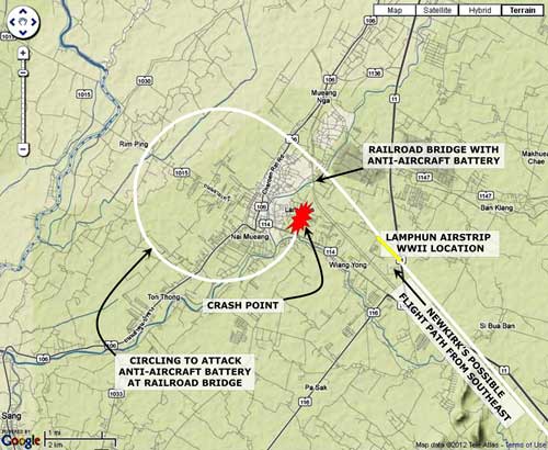
24 Mar 1942: On 24 March 1942, Flying Tiger, Frank Lawlor, accompanying Jack Newkirk on the flight that led to Newkirk’s fatal crash at Wat Phra Yuen, recorded that they had circled Lamphun town, flying over “two small satellite fields”, and then a “third and larger field”. No aircraft were sighted at any of them; however the last had “several barracks”, which they strafed.9 Lawlor then recorded that Newkirk turned north, apparently to return to Chiang Mai.10
To review, Lawlor reported three airfields:
“A larger field”, which would have been the “Lambhun military landing ground”, noted in the US War Department’s 1940 Report above.
And “two small satellite fields”, which the War Department report made no mention of; however, certain assumptions can be made:
Local Chiang Mai photographer / historian Boonserm Satrabhaya writes:11
When Japanese airmen first used Chiang Mai Airport, the RTAF shared the airport with them for some time, until the RTAF moved their planes to airfields at:
● Chiang Rai
● Ban Klang in Lamphun
● San Khao Kaeb Lan Dtong in San Kamphaeng.
1. Ban Klang: ground preparations must have been well advanced, or completed, for two days later, that field was occupied by RTAF aircraft (see entry below: 26 Mar 1942).
Unfortunately, no information about the airstrip has been found. Its location is not recorded. There is a village with that name east of Lamphun town that shows up on various maps at approximately N18°34.5 E99°04,12 about two kilometers east of the larger “Lambhun military landing ground”. Details (particularly bearing and length) are also unknown; however Google Earth shows a potential location at N18°34.59 E99°03.94.
2. Less clear is an identity for the other “satellite” airstrip. There are two possibilities, one fairly well documented, one not so:
First, Khao Kaeb, as mentioned by Boonserm:
San Khao Kaeb Lan Dtong in San Kamphaeng.
Tha Noisuya, another local resident, recalls the same airstrip:
During the war, there was another airport besides Chiang Mai airport that was used. A temporary airstrip was built at Ban San Kaokab, Moo 3 and Moo 5, Tambon Huai Sai, Amphoe San Kamphaeng. They flattened a rice field, added sand and compacted it, and used the result as a runway.
The runway was about 500 meters long. Seven airplanes parked there. Once in a while, Japanese soldiers would ride to it on a motor tricycle. The officer would sit in the front of the tricycle. They came to check their planes. These planes all had Thai pilots. Everyday there was training: they tied cloth in trees and used it for target practice.
This airport lasted for a half a year, and then it was closed as the rainy season was approaching.13
On 21 July 2011, this author with wife as translator went into the area to inquire about an old airstrip. Local government offices did not know of it. Eventually via various wats, and some of them were quite basic ‑‑‑ not all wats are beautiful and well-maintained, we found enough “old” folks to develop a concensus on the likely location, N18°47.246 E99°08.861, which is right in the middle of paddy fields, just as it was in 1942. Seventy years of cultivation have disguised (distributed) any evidence of sand fill.
But a second possibility, Ban Thi, seems to be only a word-of-mouth recollection, not recorded on paper. However, presumably somewhere southeast of Ban Thi village,14 it is much closer to Lamphun than Khao Kaeb. This requires further research.15
The four locations, one, real, “Lambhun” and the others, speculative, are summarized here, along with locations of current air facilities for reference:16

An inspection of the map suggests that neither Khao Kaeb nor Ban Thi is a realistic candidate for a “small satellite field” visible when the pilots “circled” Lamphun17 Khao Kaeb is almost as far away as Chiang Mai. Ban Thi is closer, but far from the rail line which the pilots followed into town. It is possible that the pilots’ reports were in error: they might, say, have mistaken a section of straight road close in to town for a runway.
26 Mar 1942: Squadron 42 of Combined Wing 90 moved from Chiang Mai to Ban Klang, Lamphun.18
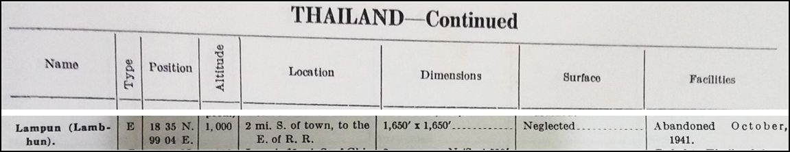
28 Jun 1942: An update of the US’s inventory of airfields in Thailand, as with the 15 March 1941 listing, included Lamphun, but with the comment “Abandoned October 1941”. The basis for this is not clear, for the airstrip remained under observation until at least January 194419
Nov 1943: “Miniatures” were a feature of Allied Airfield Reports for a time. Each miniature emphasized airfield configuration and alignment. They were designed to provide a quick reference for pilots to as many as 150 air facilities on one page. This is a miniature for the Lamphun airstrip:20
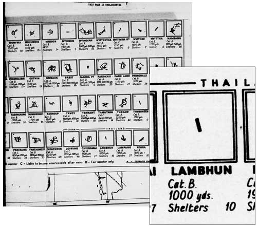
“Cat. B” indicates “Believed [to be usable in] all weather”.
The bearing of the airstrip would appear to be in error (see corrected aerial photo below).
The commentary below suggests that the IJA had assigned a low priority to the Lamphun airstrip until approximately November 1943.21 That date is significant because it implies that improvements to the airstrip were part of the preparations for support from Thailand for the IJA’s planned 1944 invasion of India:
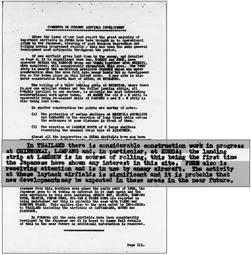
. . . the landing strip at LAMBHUN is in course of rolling, this being the first time the Japanese have shown any interest in this site. . . .
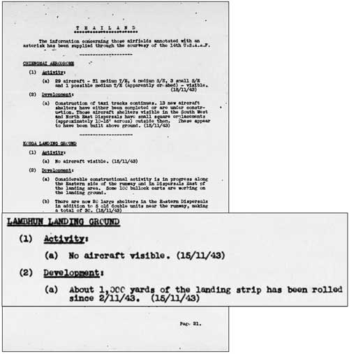
31 Dec 1943: Allied intelligence reported that the airstrip actually had some use. Unfortunately the aircraft was not identified.
And, probably following the misinterpretation of an aerial photo analyst, the text under “(2) Development” continued the fiction of the strip as oriented “north-south”.22

15 Nov 1944: And details about the work:23
16 Nov 1944: No aircraft were reported seen at the airstrip. See 15 Nov 1944 report directly above.
26 Nov 1944: From the same period is an aerial photo.24 Key details are circled:
1. “Nuang” [Kwang] River which here flows southwest and then south through Lampang town
2. Railroad bridge (unlabeled) over “Nuang” [Kwang] River
3. “Bangkok Chiengmai R/y.”
4. “Access Road”
5. Airstrip (unlabeled)
6. North arrow which is pointed 14° too far west

Reoriented to true north:25

The correction is based on the known bearing of the straight section of railroad track marked with a yellow “center line” in the photo above. It is “known” because the track is still in use today.26 With alignment of the aerial photo corrected, it can be properly positioned, as shown on the above.
Next: Lamphun Airstrip: 1944 to 1945
| 2012 Jul 28 | First published on Internet | |
| 2013 May 02 | Corrections, clarifications added | |
| 2023 May 29 | Footnotes “1957”, “1974” refs corrected | |
| 2024 Feb 29 | Converted to WordPress by Ally Taylor | |
| 2025 Mar 25 | Updated, author errors & typos corrected | |
Last Updated on 31 August 2025
- Lamphun: also rendered Lambhun, Lambohn, Lambahn, Lampoon, etc. Because of its similarity in Western spelling and pronunciation to Lampang (a city 60 air-km to the southeast of Lamphun), the two have always been confused by foreigners. It was a possible factor in Flying Tiger Jack Newkirk’s failure to fly to Lampang, his designated target, before his fatal crash. See: Bergin, Bob, “Flying Tiger, Burning Bright”, Aviation History, July 2008, p 30.[↩]
- N18°34.06 E99°02.48 Since the airstrip no longer exists, and no evidence of it is now visible in a landscape largely resculpted by construction of a major highway through the area, coordinates are based on approximations from USAAF records applied to Google Earth. See annotated aerial photos and discussion below.[↩]
- The map is a composite of information from Young, Edward, Aerial Nationalism (Washington: Smithsonian Institute, 1995), p ix, and A Survey of Thailand (Siam), (Washington: US War Department, March 15, 1941) p 101, “Civil Air Routes (Jan 1940)”, (USAF Archive Reel A2874, p 1467), superimposed on a “Terrain” map from Nations Online Project: Searchable Map and Satellite View of Thailand using Google Earth Data [herafter, Nations Online]. Annotations by author using Microsoft Publisher show solid white lines per Young and lines unique to US War Department as dashed.[↩]
- A Survey of Thailand (Siam) (Washington: US War Department, March 15, 1941), Appendix I – Airdromes, Landing Grounds, and Seaplane facilities of Thailand, v. Additional Airdromes, Landing Grounds and Seaplane Facilities of Thailand, “correct up to April 1940”, p 89 (USAF Archive Microfilm Reel B1750 p1811).[↩]
- ibid. Annotations by author using Microsoft Publisher based on Airfield Report No. 21, Apr 1944, aerial photo “Lambhun L/G”, unnumbered page (USAF Archive microfilm reel A8055 p 657) and overlaid on a “Terrain” map from Nations Online, ibid. (Annotated aerial photo available as 26 November 1943 entry below).[↩]
- Curtiss Hawk III (external link) [↩]
- บระวัติกองทัพอากาศไทย พ.ศ.๒๔๕๖ ๒๕๒๖ กองทัพอากาศ พุทธศักราช ๒๕๒๖, [Royal Thai Air Force Official History 1913-1983 (Bangkok: Royal Thai Air Force, 1983)] [hereafter, RTAF 1913-1983], pp 278-279. Same recorded in: ประวัติศาสตร์การสงครามของไทย ในสงครามมหาเอเชียขูรพา กรมยุทธศึกษาทหาร กองบัญชาการทหารสูงสุด พ.ศ.๒๕๔๐, [History of the Royal Thai Army during World War II] (Bangkok: Royal Thai Army Command School, 1997)] [hereafter, RTA 1941-1945], p 235. The Curtiss Hawk model is identified as “III” in Young, ibid, pp 184-185.[↩]
- RTAF 1913-1983, p 316. RTAF unit terminology: from Young, who also provided the transliteration “Kong Bin Noi Phasom”.[↩]
- Royal Thai Air Force history confirms that the airstrip at Lamphun was attacked: ประวัติกองทัพอากาศไทย ในสงครามมหาเอชียบูรพา พ.ศ. ๒๔๗๔ ๑๔๗๗ กองทัพอากาศ พ.ศ. ๒๕๒๕ [Royal Thai Air Force History in World War II 1941-1945 (Bangkok: Royal Thai Air Force, 1982)], [hereafter, RTAF 1941-1945] p 93. Again, see discussion at Wat Phra Yuen.[↩]
- Bergin, ibid.[↩]
- บุญเสิม สาตราภัย เชียงใหม่กับภัยทางอากาศ (กรุงเทพฯ: วิญฌูชน, 2003) Boonserm Satraphai, Chiang Mai and the Aerial War (Bangkok: Winyuchon, 2003), p 54.[↩]
- Sources:
Google Earth:
N18°34.71 E99°04.24
indexmundi: (external link)
N18°34 E99°05
Royal Thai Survey Dept
Map 4846III Series L7018S
N18°34.5 E99°04.5[↩] - The “year” referred to was apparently 1942. สังคมเมืองเชียงใหม่ เล่ม 2 พ.ต.ท. อนุ เนินหาด พิมพ์ครั้งที่ 3 พ.ศ. 2549, [Police Lt Col Anu Neinhat, Chiang Mai in World War II Chiang Mai Urban Society, Volume 2, 3rd printing 2006, ISBN 974-85311-9-8], p 62. [↩]
- N18°39.1 E99°07.5[↩]
- Tony Smallwood to David Hardcastle email of 26 Oct 2008 1050 hrs.[↩]
- Map is of “Terrain” from Nations Online, ibid, with annotations by author using Microsoft Publisher (note that this map also appears further on in this article).[↩]
 [↩]
[↩]- RTAF 1941-1945, p 94. RTAF 1913-1983, p 316.[↩]
- Airport Directory South East Asia (Washington: US Army Air Forces, 28 June 1942), p 15; (my ref: \03400 English language sources\03400 USFE Cmd Documentation\_Airfields List (Sak)\1942 Originals\19420628-08.jpg) [↩]
- Airfield Report No 16, Nov 1943, “Miniatures”, unnumbered page (USAF Archive microfilm reel A8055 p 230).[↩]
- Airfield Report No 16, Nov 1943, page III (USAF Archive microfilm reel A8055 p 236).[↩]
- Airfield Report No. 18, Jan 1944, Record of Airfield Development, Thailand, p 27 (USAF Archive microfilm reel A8055, p 470).[↩]
- Airfield Report No 16, Nov 1943, page 21 (USAF Archive microfilm reel A8055 p 276).[↩]
- Airfield Report No 21, Apr 1944, unnumbered page(USAF Archive microfilm reel A8055 p 657). NB: while dated 26 Nov 1943, the photo appeared in a report five months later. Annotations by author using Microsoft Publisher.[↩]
- ibid.[↩]
- Information derived from Google Earth.[↩]