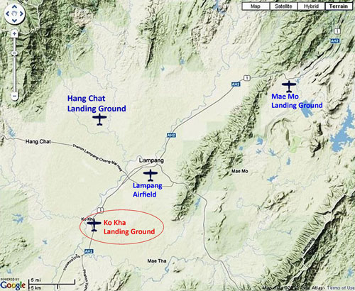
Ko Kha: Summary
Prior to the war, the Royal Thai Air Force (RTAF) operated the Ko Kha Landing Ground (Google Maps link);1 during the war, the Imperial Japanese Army Air Force (IJAAF) incorporated it into the Lampang Airfield Group as its southerly satellite air facility. Its single roughly northeast-southwest runway was located about 11 km by air southwest of Lampang Railway Station (the reference point used by Allied intelligence during WW2), and about 13 km by air southwest of the Lampang runway. No aircraft were ever observed there, though the RTAF recorded activity there. After the war, any aircraft function was apparently terminated with the land converted to various mainly public functions, which continue today.2
Aerial photo reconnaissance reports included here record coverage of Ko Kha Airstrip (Kohga Landing Ground) by only the 21st Photographic Reconnaissance Squadron (21PRS) starting in January 1944. Aerial photos by other units exist, such as that by 40PRS, but it is very limited and associated reports appear not to have been released as of November 2012.3 No WW2 era photos of the facility have been found as yet, other than the poor quality mimeographed (?) copy published in October 1943 and shown directly below. That photo was obviously the basis for the excellent map sketch, both of which firmly locate the site.
Date uncertain
The airstrip at Ko Kha is assumed to have been established sometime prior to 22 December 1941, which is the date that it was recorded as the existing headquarters for Wing 80 (see below).
1937
The second prime minister of Thailand, Phraya Phahonphonphayuhasena4 (offsite link): while born and raised in Bangkok, he oversaw the granting of a contract to the Skoda Works (Czechoslovakia) by the Thai Ministry of Agriculture to build Siam’s first 20th century sugar refinery. Its initial processing capacity of 500 tons of cane per day, was increased to 800 tons in 1939. Included in that development was a narrow-gauge railway system connecting cane fields with the mill — though without further connection to the Royal State Railways of Siam system, only 11 km north.5 The collector lines are described in BR Whyte, The Railway Atlas of Thailand, Laos, and Cambodia (Bangkok: White Lotus, 2010), p 131, and were listed in Stations and Stops in Thailand (website no longer active).
This mill apparently represented the beginning of an effort by the Thai government to recover from unfavorable trade treaties with European countries imposed in the 1870s. (deduced from Doner, Richard F and Ansil Ramsay, Growing into trouble: institutions and politics in the Thai Sugar Industry 6.
Two locomotives possibly used on the Ko Kha sugar railway in the war: Baguley (offsite link) and OK (offsite link), both listed in Michael Pass’s Preserved / Extant Steam Locos and Steam Cranes in Thailand7 (offsite link). The mill’s operational status during the war is unknown. However, a Thai Resistance member, Thosd Panthumasen, somehow associated with the mill, did assist in smuggling an Allied pilot, Theodore Demezas, who had parachuted out of his stricken plane, to a Thai-managed POW camp down in Bangkok, in the closing month of the war.8
The sugar mill is mentioned here because the origins of the airstrip in Ko Kha are unclear, and there may be an as yet undefined relationship between the mill and the airstrip. Perhaps it had been installed for the Prime Minister or Minister of Agriculture to visit and monitor the project? Or to allow Skoda technicians to respond quickly to problems? Or perhaps built for that purpose by Skoda since it was of higher quality than the airfield at Lampang? In any case, while the airstrip was not listed by the US War Department’s 1941 survey of Thai air facilities, it existed on 22 December 1941 as the location of the Thai 80th Combined Air Wing.
22 December 1941: From an RTAF official history:
The Thai government cooperated with Japan by sending the Northwest Army to help IJA troops in combat. . . . [the 80th Combined Air] Wing was under control of the Northwest Army and [initially] located in Ko Kha . . . it moved [from Ko Kha] into [Lampang (Google Maps link)] on 22 December 1941.9 [and on to Chiang Rai (Google Maps link) on 27 December 1941]10
The 61st Squadron, consisting of Martin 139Ws (offsite link)(export version of the Martin B-10) and located at Ban Phae (Saraburi) (Google Maps link), and the 62st Squadron, consisting of Nakajima Ki-21 Heavy Bombers (offsite link) and located in Khok Kathiam (Lopburi) (Google Maps link),11 were both subsequently transferred to the separate Northern Combined Group in the Northwest Army, but located at Ko Kha.12
That said, it is curious that the Ko Kha airstrip was not listed in the US War Department’s A Survey of Thailand (Siam), dated 15 Mar 1941. That publication claimed its listing included facilities under construction.13
11 May 1942: The 61st Squadron with five Martin 139WSM bombers was moved from Ko Kha to Phrae (Google Maps link). 14
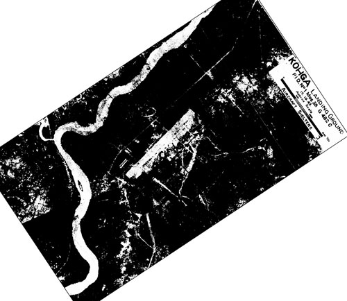
30 April 1943: An aerial photo of Ko Kha, unusually crisp in comparison with many other images available from airport reports of that period, is here reoriented so that north is top-of-page:15

It is possible that the image above may actually be a negative. Just for argument’s sake, here is the same image with blacks and whites reversed:16

Neither view appears quite right. While the second view makes the water in the river at the bottom of the photo look like a water surface, other details do not appear so straightforward.
And this Airfield Report No. 15, Oct 1943, unnumbered page (USAF Archive microfilm reel A8055 p0140).))

A larger scale image of the map sketch above is available as footnoted.17 For record purposes, the runway as depicted here measures 1,500 yards (1370 m).
28 May 1943: The 62nd Squadron with Nakajima Ki-21 heavy bombers returned to Lom Sak Air Base in Phetchabun.18
October 1943: Allied aerial photography analysts counted 10 “aircraft shelter accommodations” at the Ko Kha installation:19

From a cursory viewing of the map sketch above, it is not clear how that number was derived. Detail on the aerial photo is insufficient to verify this count.
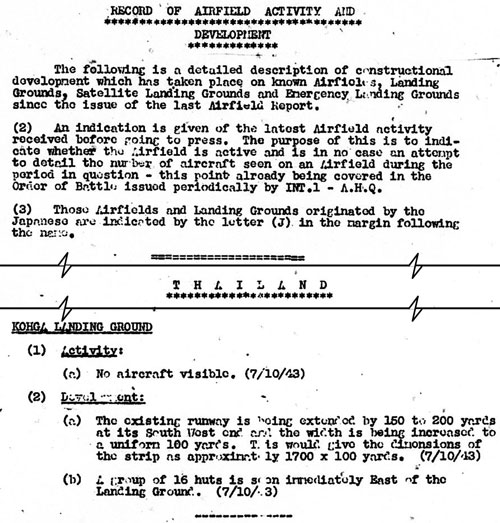
07 October 1943: This report implies that Allied Intel believed that the Ko Kha air facility was not “originated” by the Japanese since no (J) was included in the margin as described in (Item 3) below.
Construction was noted to be in progress to extend the runway 150-200 yards at the south end. That would have increased the runway total length to possibly 1700 yards (1550 m). Hence this would confirm the existing runway length as about 1500 yards, as scaled off the April 1943 photo and map above. If the extension were completed, the end of the runway would have been about 300 yards from the sugar plant property:20
Transcript of relevant text:
RECORD OF AIRFIELD ACTIVITY AND DEVELOPMENT
The following is a detailed description of constructional development . . . since the issue of the last Airfield Report.
(2) An indication is given of the latest Airfield activity received before going to press . . .
(3) Those Airfields and Landing Grounds originated by the Japanese are indicated by the letter (J) in the margin following the name.
KOHGA LANDING GROUND
(1) Activity:
(a) No aircraft visible. (7/10/43)
(2) Development:
(a) The existing runway is being extended by 150 to 200 yards at its South West end and the widthis being increased to a uniform 100 yards. This would give the dimensions of the strip as approximately 1700 x 100 yards. (7/10/43)
(b) A group of 16 huts is seen immediately East of the Landing Ground. (7/10/43)
15 October 1943: This aerial photo was taken six months after the photo above. Unfortunately there is not enough detail available in it to make any meaningful comparison, other than to confirm that the 200 yard extension had been constructed.21
November 1943: This is a so-called “miniature” for the Ko Kha airstrip, an abridged depiction, standard in Airfield Reports:22

The runway in the map sketch above dated 30 April 1943 measures 1,500 yards. The “Record of Airfield Activity and Development” above, dated 07 October 1943, recorded that the runway was being extended by 150-200 yards, which would make a new length of 1,700 yards. However, the length of the runway in this and all subsequent miniatures is stated as “1800 yds+”. But all subsequent report texts about the Ko Kha airstrip give its length as 1,700 yards, or 5,100 feet. (with the exception of one report dated 01 March 1944 with 1,600 yards)
Later in this report was an emphasis on “considerable construction work in progress . . . , in particular, at Ko Kha”:23

Transcript of relevant text:
In THAILAND there is considerable construction work in progress at CHIENGMAI, LAMPANG, and, in particular, at KOHGA . . . The activity at these layback airfields is significant and it is probably that new developments may be expected in these areas in the near future.
15 November 1943: The “construction work . . . particularly at Ko Kha” previously reported, continued — aided by an estimated 100 bullock carts:24

Transcript:
KOHGA LANDING GROUND
(1) Activity
(a) No aircraft visible. (7/10/43)
(2) Development:
(a) Considerable constructional activity is in progress along the Eastern side of the runway and in Dispersals East of the landing area. Some 100 bullock carts are working on the landing ground.
(b) There are now 20 large shelters in the Eastern Dispersals in addition to 5 old double units near the runway, making a total of 30. (15/11/43)
31 December 1943: On this last day of the year, it should be noted that no aircraft had been reported visible on the runway during the entire year while total aircraft shelters had grown to 32, which would not further increase:25

The terms “surfacing” and “metaling” are discussed here.
| First published on Internet | ||
| Content materially expanded; page 3 supplemented by site visit. | ||
| 2 | 2024 Feb 29 | Converted to WordPress by Ally Taylor |
| 3 | 2025 May 04 | Updated, author errors & typos corrected |
Last Updated on 20 February 2026
- N18°11.90 E99°24.67 Coordinates source: Google Earth. Name was also transliterated as Kohga, Koh Kha, Go Ka, Gorka. The first part of the place name, Ko, or เกาะ, is defined as island in Thai. With regard to Ko Kha, it apparently refers to a time when the meandering Wang River had carved out paralleling channels to form a temporary island in the area. Note: not listed in Air America’s Air Facilities Data Thailand 432, 1971.[↩]
- “Terrain” map from Nations Online Project: Searchable Map and Satellite View of Thailand using Google Earth Data, a website no longer available. Annotation by author using Microsoft Publisher.[↩]
- See page on USAAF Aerial Photographic Intelligence.[↩]
- Phahonyothin Road (offsite link), aka, “Route 1”, Thailand’s main north-south road, is named after him, and passes close by the old sugar mill site[↩]
- Information found by Jack Eisner in “Economic Relations Across Oceans”, in Nožina, Miroslav, Siam Undiscovered (Bangkok: Amarin, 2004), pp 86-88.
The railway track was apparently still intact in 1971 since it is shown in RTSD map entitled Amphoe Ko Kha of that date.((Added on 15 Jun 2014: [↩]
- site may require registration: URL: https://www.thefreelibrary.com/Growing+into+trouble%3a+institutions+and+politics+in+the+Thai+Sugar…-a0114326980 >, (offsite link — Jl of East Asian Studies, 2004[↩]
- Added 01 Aug 2014[↩]
- Thai Air Accidents (offsite link) p 4: 12-Jul-45[↩]
- บระวัติกองทัพอากาศไทย พ.ศ.๒๔๕๖ ๒๕๒๖ กองทัพอากาศ พุทธศักราช ๒๕๒๖ [Royal Thai Air Force Official History 1913-1983 (Bangkok: Royal Thai Air Force, 1983)], pp 277-278.[↩]
- Young, Edward M, Aerial Nationalism (Washington: Smithsonian, 1995) [hereafter Young], p185[↩]
- Young, p 184; the two were also titled Combined Wing 6 (Young, p 266) in keeping with his explanation that the first digit represented the peacetime squadron while the second was the assignment within the squadron (Young, p 178).[↩]
- The 61st Squadron was originally assigned to Don Muang (Google Maps link) in 1937 (Young, p 179); how it got to Ban Phae is unclear, unless perhaps it was considered a satellite of Don Muang. The 62nd Squadron had been ordered to Lomsak, Petchabun (Google Maps link) on 16 December 1941 per ประว้ติกองท้พอากาส ในสงครามมหาเอเชียบูรพา ระหว่าง พ.ศ.-๒๔๘๔-๒๔๘๘ จ้ดพิมพ์เป็นที่ระลืก ในโอกาส ๘๐ ปี สดุดีวีรชนสงครามมหาเอเชียบูรพา ๘ ธ้นวาคม ๒๔๘๔ (นครราชสีมา: สมบูรณ์การพิมพ์, พ.ศ.๒๕๖๔ [History of the Royal Thai Air Force In the Great East Asia War Between 1941-1945 (Nakhon Ratchasima: Somboon Printing, 2021)], p 60 (hereafter RTAF WW2), though Young lists it at Khok Kathiam on 22 December 1941.[↩]
- A Survey of Thailand (Siam), (Washington: US War Department, March 15, 1941), Appendix I – Airdromes, Landing Grounds, and Seaplane facilities of Thailand, v. Additional Airdromes, Landing Grounds and Seaplane Facilities of Thailand, “correct up to April 1940”, p 89 (USAF Archive Microfilm Reel B1750 pp1810-1813).[↩]
- RTAF WW2, p 95[↩]
- Airfield Report No. 15, Oct 1943, unnumbered page (USAF Archive microfilm reel A8055 p0139).
Note that while published in Oct 1943, the photo itself was dated 30 Apr 1943 (at bottom right):

Comparison of details on this photo with those available today establishes the bearing of the runway as almost exactly 045/225.
All images from Airfield Reports are believed to have been degraded by, one, mimeographing for distribution at issue, and, two, later microfilming for the permanent records from which these images have been obtained.[↩]
- ibid.[↩]
-
 [↩]
[↩] - RTAF WW2, p 147[↩]
- Airfield Report No. 15, Oct 1943, pp 7, 9 (USAF Archive microfilm reel A8055 pp 0160, 162).[↩]
- Airfield Report No. 15 (Oct 1943), “Record of Airfield Activity and Development”, pp 10, 29 (USAF Archive microfilm reel A8055 pp 0163, 182).[↩]
- Airfield Report No 16, Nov 1943, aerial photo, unnumbered page (USAF Archive microfilm reel A8055 p0195).[↩]
- Airfield Report No. 16,Nov 1943, Airfield Miniatures, unnumbered page (USAF Archive microfilm reel A8055 p 0231). [↩]
- Airport Report No. 16 (Nov 1943), “Comments on Current Airfield Development”, page III (USAF Archive microfilm reel A8055 p 0236).[↩]
- Airport Report No. 16 (Nov 1943), “Record of Airfield Activity and Development”, page 21 (USAF Archive microfilm reel A8055 p 0276).[↩]
- Airport Report No. 18 (Jan 1944), “Record of Airfield Activity and Development”, page 26 (USAF Archive microfilm reel A8055 p 0469).[↩]