Mae Mo: Summary
Mae Mo (Google Maps link) Landing Ground1 was the easterly satellite air facility in the Lampang Airfield Group of the Imperial Japanese Army Air Force (IJAAF). The facility’s two runways, the better developed one, running NNE-SSW, and the other, N-S, formed an “X”. It was located approximately 31 km by air northeast of Lampang Railway Station (the reference point generally used by Allied intelligence during WW2), and about 28 km by air from the Lampang runway. Constructed by the Japanese in 1944-1945, no aircraft was ever observed there. There is evidence on the ground and in local oral history of at least one effective Allied targeting of the facility. After the war, surrounding forests which had best contrasted the runways for Allied pilots were cut down, with the runways themselves almost disappearing into the rice field panorama that now covers the immediate area.2

Aerial photo flight reports below record coverage of Mae Mo Airstrips (Memoh Landing Ground) by only the 21st Photographic Reconnaissance Squadron (21PRS). Other coverage probably exists, but records seem not to have been released as yet. No WW2 era photos of the facility have been found either (other than the extremely poor quality mimeographed (?) copy published on 11 November 1944 and shown below, and republished in January 1945 as seen on the next page).
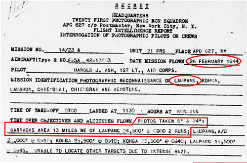
February 1944: 21PRS, based in Kunming, China, was one Allied unit that made aerial photographs of features in Thailand. The Mae Mo airstrip was about 800 km (500 mi) SSW of Kunming. One of the areas targeted in this aerial photo request below was not named, but the only site anywhere close to the specified 13 miles (21 km) northeast of Lampang was Mae Mo, which was actually about 19 miles (31 km) away (as measured to the Lampang railway station):3
07 March 1944: The diagram below stands out as unusually crude amongst most other Allied intel graphics (for example, compare another map of the same area in February 1945). The manner of presentation suggests an unscaled schematic rather than a map. It places the Mae Mo airstrip close to the railway station, the latter actually being 16 km south. The actual bearing of the railway track at Mae Mo Station is 45°-225°, not east-west as shown in the sketch. It seems probable that the crudity of the sketch was the result of a source “on the ground” who was not familiar with the rigors of map making. Note that the publisher was the South-East Translation and Interrogation Center:4

April 1944: In a comprehensive table published in January of the next year about the Lampang Airfield Group — of which Mae Mo was a part — the Mae Mo air facility was recorded as having been first observed on 25 April 1944. Curiously the April date was about two months after the two reports above were dated. No explanation has been found for the eventual use of the later April date.
19 June 1944:5 341st Bombardment Group unit records describe a task assigned to the 22nd Bombardment Squadron as Mission B247, that of bombing the Kaeng Luang Railway Tunnel (assumed to have been the Huai Mae Lan tunnel):6
Four 22nd B-25s took off from Yangkai Airfield, Yunnan (Google Maps link) at 0700 hours to attack the tunnel and all four succeeded in reaching the target, which was observed through breaks in the clouds. These breaks, however, were neither sufficiently large nor frequent enough to permit a bomb run. . . .
Planes 43-3617 and 43-3958, after repeated attempts, finally located a break (in the clouds) and spotted an airfield having two runways crossing in an ‘X’ pattern. These two planes dropped all bombs on the airfield but results were completely obscured by the cloud overcast. . . .
In the north of Thailand, there was only one “X” pattern airfield: Mae Mo, and the current rice paddy terrain at the former site still displays bomb craters. Ironically Allied reconnaissance never observed any aircraft there. Note that the “X” pattern had not been designated for bombing, but had become a target only by accident. Lampang’s other two satellite airfields, Hang Chat and Ko Kha were never attacked.
September 1944: Here, Allied Intel labeled Mae Mo as one of the three “most interesting” newly discovered sites “during the month” in Southeast Asia, and it was accurately located 19 miles ENE of Lampang (railway station) — while billed as “newly discovered” this month (presumably September), recall that the unscaled sketch just above was dated six months earlier:7
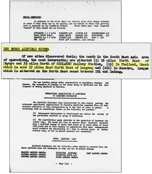
Transcript of relevant text:
NEW ENEMY AIRFIELD SITES:
. . . In Thailand, Memoh which is some 19 miles East North East of Lampang . . . .
Within the same report, the location of Mae Mo airstrip(s) became a bit more fluid. The north (N) position coordinate is okay; the east (E) position coordinate differs with standards today, but that difference probably partly reflects the Indian datum used as a reference in Thailand at that time. The reference to Mae Mo Village is now obscure: if it was in fact located three and a half miles south of the airstrip(s), the village was subsequently totally enveloped by the open pit coal mine. The community currently bearing the name, Mae Mo, is about 16 km (10 mi) south) of the airstrip, in the area of the railway station:8
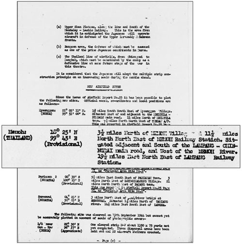
Transcript of relevant text:
Memoh (THAILAND)
18°25’N 99°45’E (Provisional)
3½ miles North of MEMOH Village and 11½ miles North North East of MEMOH Railway Station. Situated adjacent and South of the LAMPANG – CHIENGRAI main road, and West of the MEMOH River. 19½ miles East North East of LAMPANG Railway Station.
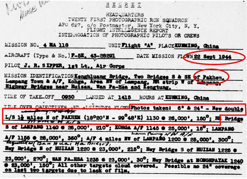
22 September 1944: Four days later there was a photo order that included two bridges south and southeast of Pakhem.9 The coordinates for Pakhem were provided in the order and placed it 12 km (8 mi) southeast of the Mae Mo air facility. No photo information for the targeted bridges was described in the results. The results did describe “double L/S” (landing strips) nearby Pakhem and there was only one air facility in the area with such a configuration: Mae Mo.10
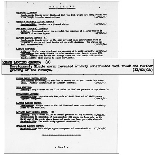
21 October 1944: Construction was noted as continuing per an observation probably made 21 October 1944 (the same day as the comment preceding it which noted no aircraft having been observed during the period). The continuous reporting of construction observed in the previous six months implied a concerted effort to prepare the airstrips. The (J) following the title Memoh Landing Ground is the first indication that Allied Intelligence had evaluated the airstrip as being a Japanese effort, not a Thai one:11

Transcript of relevant text:
MEMOH LANDING GROUND (J)
Activity: Infrequent cover during the month failed to disclose the presence of any aircraft. (21/OCT/44)
Development: Construction of this landing ground is still in progress.
25 October 1944: Allied planners introduced the concept of the “Thailand Line of Airfields”, in an anticipation that the Japanese army, on retreating from its failed invasion of India, would “hold its ground” in Burma with support from Japanese resources in Thailand:12
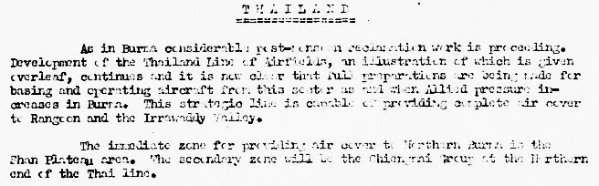
Text of above (smoothed):
Thailand:
As in Burma considerable post-monsoon reclamation work is proceeding. Development of the Thailand Line of Airfields, an illustration of which is given overleaf [see below], continues and it is now clear that full preparations are being made for basing and operating aircraft from this sector as and when Allied pressure increases in Burma. This strategic line is capable of providing complete air cover to Rangoon and the Irrawaddy Valley.
The immediate zone for providing air cover to Northern Burma is the Shan Plateau area. The secondary zone will be the Chiang Mai Group at the Northern end of the Thai line.13

Text circled above (smoothed):
Mae Mo Landing Ground
• Airstrips of rolled earth are under construction.
• North-south. About 1700-1800 yards.
• Northeast-southwest. About 1700-1800 yards.
• Category C [liable to become unserviceable after rains]
• 0 aircraft shelters
• A new site in an early stage of construction
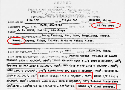
25 October 1944: An attempt to photograph Memoh A/F was unsuccessful due to cloud cover:14
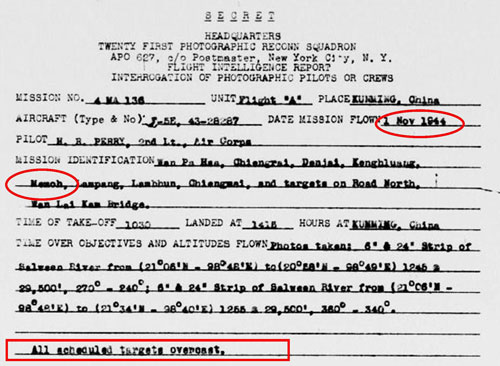
01 November 1944: Another photo request, just a week later, for Memoh failed due to cloud cover:15
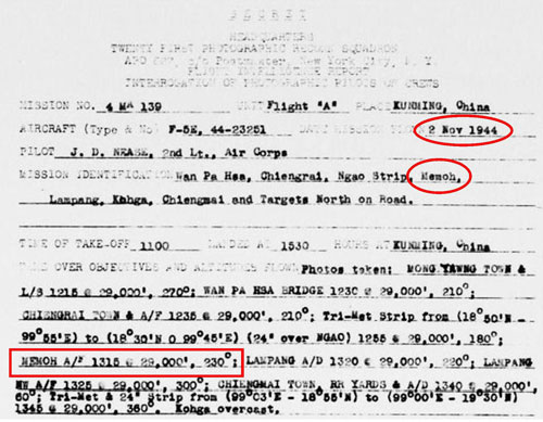
02 November 1944: In a third attempt in just over a week, targets in northwest Thailand, including the Mae Mo airstrips, were finally successfully photographed:16
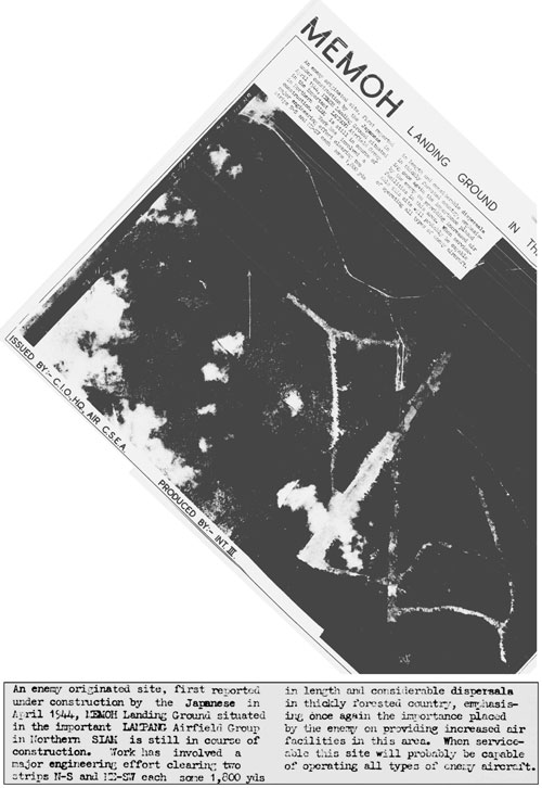
11 November 1944: The first aerial photo of Mae Mo was published, but the copy now available is such poor quality as to be nearly meaningless. It has here been reoriented so that photo north points to the top of this webpage:17
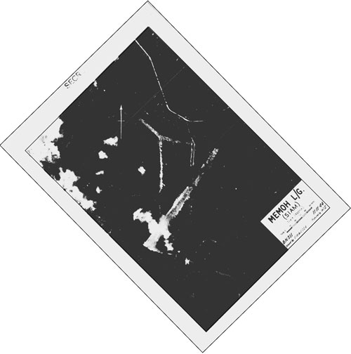
And an interpretation on the same date noted evidence of continued construction:18
Transcript of relevant text:
MEMOH LANDING GROUND: (J)
Development: Single cover revealed a newly constructed taxi track and further grading of the runways (11/NOV/44)
19 November 1944: This schedule carried information noted as valid “up to” 15 November 1944. First time information included runway and accommodation data:19

Transcript of new information:
Surface: Rolled earth
Serviceability: Dry-weather only. Heavy rains during SW Monsoon period May-October
Installations: Living accommodation in barracks on airfield; Taxi tracks
15 December 1944: Interpretation of aerial photos became more detailed as the north-south runway neared completion:20
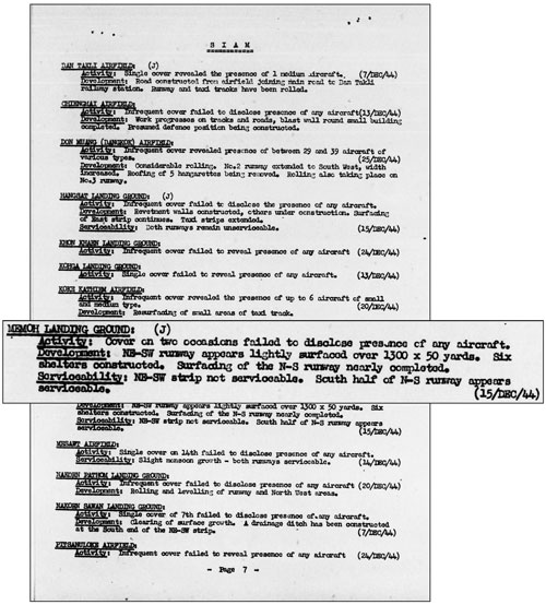
Transcript:
MEMOH LANDING GROUND: (J)
Activity: Cover on two occasions failed to disclose presence of any aircraft.
Development: NE-SW runway appears lightly surfaced over 1300 x 50 yards. Six shelters constructed. Surfacing of the N-S runway nearly completed.
Serviceability: NE-SW strip no serviceable. South half of N-S runway appears serviceable. (15 Dec 44)
31 December 1944: And, as interpretation became more detailed (as shown just above), in the same month, formality and detail of published information became more sophisticated:21
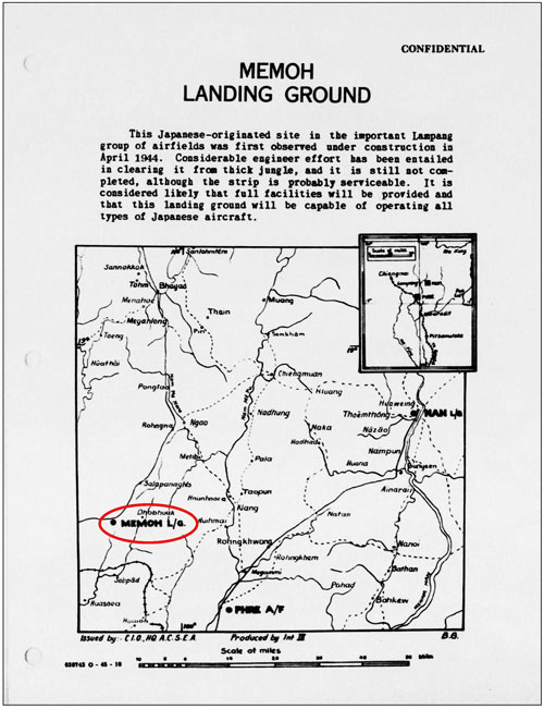

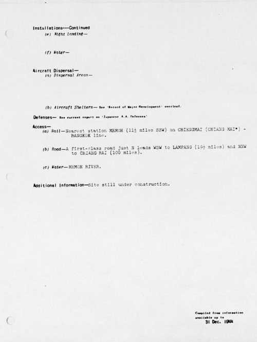
TRANSCRIPT (first page):
MEMOH LANDING GROUND
This Japanese-originated site in the important Lampang group of airfields was first observed under construction in April 1944. Considerable engineer effort has been entailed in clearing it from thick jungle, and it is still not completed, although the strip is probably serviceable. It is considered likely that full facilities will be provided and that this landing ground will be capable of operating all types of Japanese aircraft.
TRANSCRIPT (pages 2 and 3):
Coordinates — 18°25’N; 99°45’E
Altitude (feet above mean sea level) — 1300 (approx)
Map Reference — Siam 1/1,000,000 NE47 and ¼” NE-47J
Local Position and Landmarks — 3-1/2 miles north of [Mae Mo] village and 11-1/2 miles NNE of [Mae Mo] railway station; just south of Lampang-Chiang Rai main road and west of [Mae Mo] River; 19-1/2 miles ENE of Lampang railway station.
Landing Area (dimensions in feet) — Runway and strip intersecting in form of X.
Runway: NE-SW 5100 x 300 (approx)
Strip : N-S 5100 x 165 (approx)
Obstructions —
Surface — Runway being metaled; strip rolled earth.
Serviceability — Runway will probably be all-weather, remainder serviceable in dry weather only. Heavy rains during SW monsoon, May to October.
Installations —
(a) Administration and Living Accommodations —
Temporary living accommodations in barracks
to north of landing ground, and in village.
(b) Hangars and Workshops —
(c) Storage —
(i) Fuel and Oil —
(ii) Bomb and Ammunition —
(iii) General Stores —
(d) Telephone, W/T, Signals, etc —
(e) Night Landing —
(f) Water —
Aircraft Dispersal —
(a) Dispersal Areas —
(b) Aircraft Shelters: — See “Record of Major Development” overleaf.
Defenses — See current report on “Japanese AA Defenses”
Access —
(a) Rail — Nearest station [MEMOH] (11-1/2 miles SSW)
on CHIENGMAI (CHIANG MAI*) – BANGKOK line.
(b) Road — A first-class road just north leads WSW to
Lampang (19-1/2 miles) and NNW to Chiang Rai (100 miles).
(c) Water — MEMOH RIVER
Additional Information — Site still under construction.
January 1945: A map of the Lampang Airfield Group displays this table:22

The entry above for “Memoh” reads:
| First observed | 25 April 1944 |
| Runway or strips | 1700 Yds, 1700 Yds |
| Surface | NS Rolled earth; NE-SW being installed |
| Shelters | 6+ |
| Type of A/C seen in last 12 months |
Nil |
| Weather serviceability |
NS: Liable to become unserviceable after rain NE-SW: Probably all weather when complete |
In addition, the Lampang Airfield Group map provides this inset location guide for Mae Mo:23

All the place names appear on Royal Thai Survey Department (RTSD) map 4945 IV (2007) except for the most southerly two, “Ban Go” and “Ban Mea Mo”. Both would appear to have been absorbed by the open pit mine excavation.The photo below, published with north askew, has been rotated so that its north points towards the top of this page. The full title of the aerial photo below is “Memoh Landing Ground in the Lampang Group, Siam”. While the accompanying text does not date the photo, it was published in the January 1945 edition of Airfield Reports: however it appears identical to the aerial photo dated 11 November 1944 (on the previous webpage).24
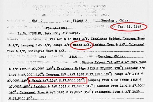
05, 13 January 1945: Mae Mo was aerial photographed two weeks in a row — 05 and 13 January 1945:25

13 January 1945: While this brief paragraph is undated, comments in the same section about other air facilities in the immediate area were dated 13 January 1945:26
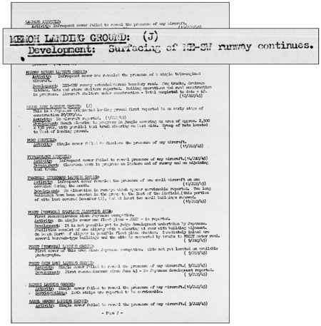
Transcript:
MEMOH LANDING GROUP
Development: Surfacing of NE-SW runway continues.
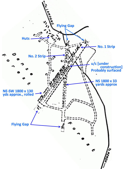
February 1945: This sketch finally clearly located the Mae Mo airstrip (note that the sketch is here not oriented with north to the top of the page):27

TRANSCRIPT of relevant text in the box above:
Sketch Plan of MEMOH L/G [Landing Ground]
SIAM
18°25′ N 99°45′ E provisional
Map: THAILAND NE/47J, 1941 Edition
[scale]
Correct to 5M/124 (13-2-45) [data]
CPIC / PLANS/361/445 ACSEA/4300/G
This L/G is being constructed by the Japanese and was first seen in Sep/44.
It lies in a thickly forested area.
LANDING AREA: Two intersecting strips with flying gaps.
SERVICEABILITY: NE-SW strip serviceable. N-S strip under construction.
DISPERSAL: Taxi-tracks rolled or lightly surfaced.
AIRCRAFT SHELTERS: 8 large shelters dispersed in clearings.
AIRCRAFT ACTIVITY: No aircraft has been seen on this L/G.
The diagram from the report page above is extracted, reoriented with north up-page, and annotated to clarify muddy text:28
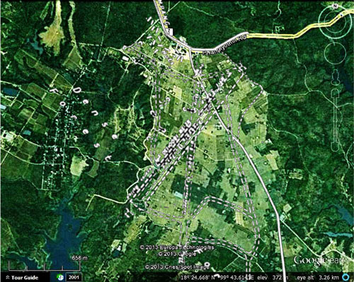
Here the diagram above is rescaled and superimposed on a current Google Earth view to make an overlay map of the area:29
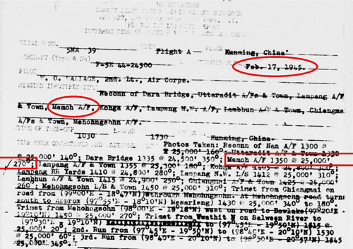
17 February 1945: And a month later, another aerial photo order:30
24 March 1945: Finally, a comment:31

TRANSCRIPT:
Occasional cover failed to reveal presence of any aircraft (24/Mar/45).
This comment apparently became a conclusion, for no further 21PRS flights were ordered over Mae Mo (though another PRS could have received such orders).
April 1945: In this month, the Mae Mo airstrip(s) received considerable attention.
The following amendment in Airport Report No. 33 is assumed to refer to the last detailed report on the Mae Mo “Landing Ground” in Airfield Report No. 28, November 1944 (not the Siam (Thailand): List of Airfields and Seaplane Stations, “Memoh Landing Ground” report in December 1944).32
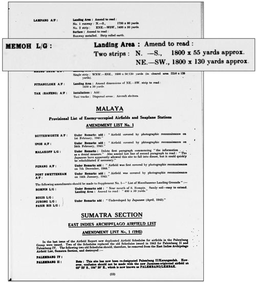
Comparison of old and new data (all dimensions are in yards):
| 1700/1800 x 55 | 1800 x 55 | |
| 1700/1800 x 55 | 1800 x 130 |
May 1945: Mae Mo was identified as under Japanese control in Airfield Report No. 27 in 21 October 1944. Here all Thai “Airfield Completely Under Japanese Control” are grouped together (the alternative designation is “Joint Control”):33
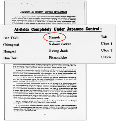
TRANSCRIPT of applicable text:
Memoh and Hangsat are apparently disused at present.
And that conclusion is echoed a few pages later in the report:34
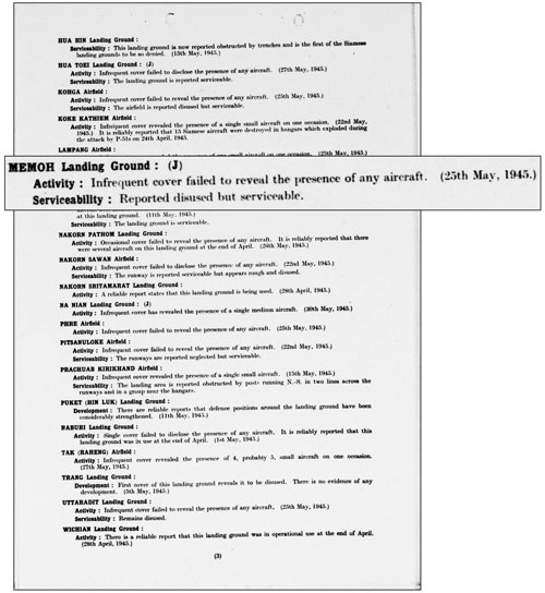
Transcript:
MEMOH Landing Gear: (J)
Activity: Infrequent cover failed to revel the presence of any aircraft (25 May 1945)
Serviceability: Reported disused but serviceable.
No references to Mae Mo Landing Ground past April 1945 have been found in USAAF reports.
| 2013 Sep 15 | First published on Internet | |
| 2014 Jan 05 | Content materially expanded | |
| 2015 Apr 20 | Minor additions | |
| 2024 Feb 29 | Converted to WordPress by Ally Taylor | |
| 2025 Dec 13 | Updated, author errors & typos corrected | |
Last Updated on 13 December 2025
- N18°24.80 E99° 43.70 Coordinates source: Combination of GPSs from site visit and Google Earth. During WWII: “Memoh”. Uncommonly, “Memeh”. As an administrative district in Lampang Province, Mae Mo covers almost a thousand square kilometers. The name is best known as that of the Mae Mo open pit (opencast) lignite mine with the largest electrical generation facility in the north located next to it. A subdistrict and a railway station carry the same name and are near the power plant. This all proved very confusing in trying to locate the IJAAF Mae Mo airstrip, until Allied intelligence maps pinpointed its location, well north of that collection of names. More correctly, it is in Ban Ta Sri, Tambon Ban Dong, Amphoe Mae Mo. Note: not listed in Air America’s Air Facilities Data Thailand 432, 1971.[↩]
- “Terrain” map from Nations Online Project: Searchable Map and Satellite View of Thailand using Google Earth Data (site no longer available). Annotation by author using Microsoft Publisher.[↩]
- 21st Photographic Reconnaissance Squadron (hereafter 21PRS) Report Mission No. 14/23A, 26 Feb 1944 (USAF Archive microfilm reel A0878 p0118). There was more than one Allied unit charged with aerial photography over Thailand, but the only order sheets found to date are those from the 21PRS.
A short explanation of aerial photograph orders is at USAAF Aerial Photographic Intelligence.[↩]
- Plans of Airfields in French Indo-China and Siam (Publication No. 3.II) (South-East Asia Translation and Interrogation Center, 30 Nov 1944), Map No. 67, “Memoh Airfield 3 Mar 44” unnumbered page, (USAF Archive microfilm reel A8023 p0453).[↩]
- Detail for 19 Jun 1944 added 11 Apr 2015.[↩]
- Courtesy of Tony Strotman mgr, website, 341st Bombardment Group (offsite link to website being rebuilt, May 2025). (Mission B-247. Operational Intelligence Report, CD A0543 image 916/page 938).[↩]
- Airfield Report No. 26, Sep 1944, “Comments on Current Airfield Development”, p (ii) (USAF Archive microfilm reel A8055 p0969).[↩]
- Airfield Report No. 26, Sep 1944, “New Airfield Sites”, p (v) (USAF Archive microfilm reel A8055 p0976).[↩]
- Pakhem no longer exists — it was absorbed by the sprawling Mae Mo lignite surface mine whose product powers the Mae Mo Power Generation Plant.[↩]
- 21PRS Report Mission No. 4 MA 118, 22 Sep 1944 (USAF Archive microfilm reel A0878 p0476).[↩]
- Airfield Report No. 27, Oct 1944, “Record of Airfield Activity and Development”, p 9 (USAF Archive microfilm reel A8055 p1019). Note that the last 21PRS photo mission over Mae Mo was dated 22 September 1944. The comment about “infrequent cover during the month” would appear to have spurred subsequent pointed efforts on 25 Oct, 01 Nov, and 02 Nov to photograph the site.[↩]
- Airfield Report No. 27, Oct 1944, “Comments on Current Airfield Development”, “Thailand”, p ii (USAF Archive microfilm reel A8055 p0998). The term “Chiang Mai Group” in reference to WW2 airfields appears nowhere else in the literature. Its meaning is unclear. My ref: (same as) \02370 Hang Chat\Working\19441000 A8055 p0998.jpg.[↩]
- Airfield Report No. 27, Oct 1944, “Thailand Line of Airfields”, unnumbered page (USAF Archive microfilm reel A8055 p0999).[↩]
- 21PRS Report Mission No. 4 MA 132, 25 Oct 1944 (USAF Archive microfilm reel A0878 p0551).[↩]
- 21PRS Report Mission No. 4 MA 136, 01 Nov 1944 (USAF Archive microfilm reel A0878 p0567).[↩]
- 21PRS Report Mission No. 4 MA 139, 02 Nov 1944 (USAF Archive microfilm reel A0878 p0568).[↩]
- Airfield Report No. 31, Feb 1945, “Memoh L/G” (dated 11 Nov 1944), unnumbered page (USAF Archive microfilm reel A8056 p0014).[↩]
- Airfield Report No. 28, Nov 1944, “Record of Airfield Activity and Development”, p 8 (USAF Archive microfilm reel A8056 p1133).[↩]
- Airfield Report No. 28, Nov 1944, “Memoh Landing Ground”, unnumbered page (USAF Archive microfilm reel A8055 p1081).[↩]
- Airfield Report No. 29, Dec 1944, “Record of Airfield Activity and Development”, “Siam” (data dated 15 Dec 1944), p 7 (USAF Archive microfilm reel A8056 p1181).[↩]
- Siam (Thailand): List of Airfields and Seaplane Stations, “Memoh Landing Ground”, (data dated to 31 Dec 1944) unnumbered page (Washington DC: Office of Assistant Chief of Air Staff, Intelligence, 1945) (USAF Archive microfilm reel A1285 p1237).[↩]
- Airfield Report No. 31, Feb 1945, “Lampang Airfield Group” (map) (extract), unnumbered page (USAF Archive microfilm reel A8056 p0003). Note that the table is dated January 1945 and is carried here chronologically as in that month; however, the table was actually published in the February edition of the Airfield Report.[↩]
- ibid.[↩]
- Airfield Report No. 30, Jan 1945, unnumbered page (USAF Archive microfilm reel A8055 p1253).[↩]
- 21PRS Report Mission No. 5 MA 4, 05 Jan 1945 (USAF Archive microfilm reel A0878 p0815) and 21PRS Report Mission No. 5 MA 9, 13 Jan 1945 (USAF Archive microfilm reel A0878 p0807).[↩]
- Airfield Report No. 30, Jan 1945, “Record of Airfield Activity and Development”, p 7 (USAF Archive microfilm reel A8055 p1270).[↩]
- Airfield Report No. 33, Apr 1945, “Memoh L/G”, unnumbered page (USAF Archive microfilm reel A8056 p0175).[↩]
- ibid (extract) superimposed on Google Earth view. Annotated by author using Microsoft Publisher.[↩]
- “Memoh L/G”, ibid (extract) superimposed on Google Earth view of Ban Pang area, Mae Mo District. Assembled and annotated by author using Microsoft Publisher.[↩]
- 21PRS Report Mission No. 5 MA 39, 17 Feb 1945 (USAF Archive microfilm reel A0878 p0769).[↩]
- Airfield Report No. 32, Mar 1945, “Record of Aircraft Activity & Development”, p 7 (USAF Archive microfilm reel A8056 p0126).[↩]
- Airfield Report No. 33, Apr 1945, “Part II. Amendments to Airfield Lists – Siam”, p 11 (USAF Archive microfilm reel A8056 p0174).[↩]
- Airfield Report No. 34, May 1945, p i (USAF Archive microfilm reel A8056 p0294).[↩]
- Airfield Report No. 34, May 1945, “Record of Airfield Activity and Development”, p (3) (USAF Archive microfilm reel A8056 p0302).[↩]