Don Kaeo Burial Site
As the Imperial Japanese Army (IJA) withdrew from disastrous defeats in India and Burma, two IJA hospital units were assigned to Don Kaeo (Google Maps link),1 just north of Chiang Mai, to receive troops wounded from those battles.2 Already incapacitated and further exhausted from an arduous 280 km trek across the mountains from Mae Hong Son Province, many of those who survived the journey died in the hospital units which were severely underequipped and poorly supplied. The hospitals buried their dead about a half kilometer west of their camps.
Neither the locations of the hospital camps nor the associated gravesites are marked on the ground, which is somewhat surprising in view of the nearly 400 remains recovered there and the remains estimated yet to be disinterred. The only reference found for this site to date is in the Japanese language work, Journal on Collection of War Dead: Burma, India, Thailand3 That source, however, does itself quote numerous Japanese language references.
Key excerpts are presented first, followed by an attempt to match points on the ground with the Journal‘s map of the site. Photographs of the sites follow. Finally an appendix gives more details from the book.

Mentions in the literature:
In 1977-1978, Japanese war veteran groups working under the motto . . . “Leave not one body behind”. . . . located what they later described as “the largest [single] graveyard” found during their 1977-1978 operations. The remains of 385 IJA troops were recovered there.4
Commentary includes:
. . . a teak forest . . . four kilometers northwest of Chiang Mai, where the 121st and 124th Military Hospitals operated, with a graveyard about 500 m to the west.5
Here the two hospitals were established and took in patients. . . . Half a km west of the hospital was a graveyard for men and officers. . . . 4
Various comments by investigation team members were cited:
Investigation Group member Tsuzuki remembered:
. . . the more talk about our request for cooperation progressed, the more often the word “Don Kaeo” came out. It resembled “Ronkyou”, the phantom military hospital whose location had still not been made clear . . . .
. . . According to [Don Kaeo] Mayor Yamana, between km posts 9 and 11, and 2 km to the west, there had been a Japanese soldiers camp. One km west of milestone 9 was the graveyard. The features of the land had completely changed from that time: ten years earlier [1967-1968] a canal had been dug, and now the land was part of a military facility.4
First Group Member Okumura recalled:
The collection group, with the goodwill of the military, was able to excavate that graveyard. The location was 9 km to the north of Chiang Mai [p 448] and about 2 km west, in the middle of several high hills. It was inside a military property under the jurisdiction of a Thai army artillery brigade. In the middle of a forest flush with maihyon shrubs that have broad leaves like a teak, within a 5,000m² area, a number of officers and men slumbered.
Between 24 January and 02 February, working continuously, we recovered 268 remains. The neighboring villages collectively known as Don Kaeo had been called “Ronkyou” by the Japanese army. . . . The remains that we recovered each day were collected in a temporary rest area . . . the remains were taken to Wat Suan Dok in Chiang Mai. . . . 6
Fuhihara remembered:
The information about the Don Kaeo region involved two areas, but only from Area No. 1 did we retrieve bones. From Area No. 2, alias ‘Paradise Stadium’, we were unable to retrieve bones, but it is a spot which we can hope to investigate next time.
The remains of the dead were laid out about one meter apart in neat rows. In each hole would be two or three skeletons; all were aligned with heads to the north-northwest, ie, towards Japan. There was no particular difficulty with the work, but about half of all the remains had totally disintegrated. What was left were mostly large bones — skulls and femurs — and some fragments of pelvic bones and upper arm bones. All the bones were subject to the action of a certain bush indigenous to Thailand whose roots had penetrated bone marrow to absorb nutrients: were you to try to pull away the dirt or the root, the bone would just crumble.7
Maps of Don Kaeo burial area:
To supplement the descriptions, the book provided a map:4

Sufficient details visible on a Google Earth view of the area8 (called out with blue circles and white-colored notes) seem to fairly well locate the Journal map above:
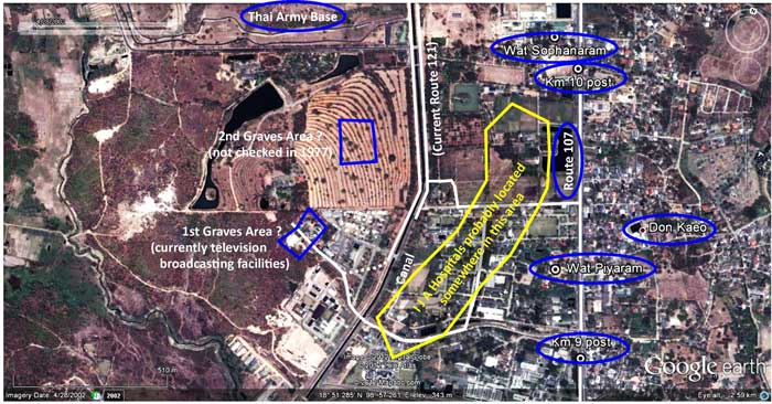
Note the area marked with yellow: while the Journal map does not call this out, the hospitals can be generally located by the description that the burial areas were half a kilometer to the west of the hospitals.
Photos of locations about the Don Kaeo burial area in the Journal on Collection of War Dead
On the ground (Google Maps link), looking west from Route 121 across the khlong at the general area of the grave sites9

Wat Piyaram (Google Maps link) on Thai Route 107 at Station 9+300:10


Wat Sophanaram (Google Maps link) on Route 107 at Station 10+100:13


There is nothing on the grounds of either wat related to Japan. When I visited Wat Piyaram in March 2008, I was told that a Buddhist monk from Japan had long stayed there and might have had useful information, but that he had just recently left.
In between the two wats are several lanes heading west from Route 107. One more likely than others to have been that shown in the Journal map is this one at Route 107, Station 09+500 (Google Maps link):16

Other items relevant to the Don Kaeo site
The Journal does not mention a small Japanese memorial at a wat about four kilometers further north on Thai Route 107: Wat Sawang Ban Thoeng (Google Maps link)17. No doubt it was dedicated long after the Journal was completed.

The approach to the wat entrance is obscured by a roadside market; however the wat rooftops are still visible beyond18

Turn left immediately on entering the wat grounds and the memorial will be visible in the corner19

The memorial is in the form of a freestanding tablet:20
The Thai text reads:
The people of Japan give their thanks to the people of Thailand for their help during WWII.
The Japanese text reads:
It is hoped that the day will come when people everywhere:
. . . don’t kill anymore.
. . . help each other without hatred
. . . are peaceful.
In addition, for clarification, it is noted that there is a Wat Don Kaeo (Google Maps link), about one kilometer east of Station 12+00 on Thai Route 107. Located about 2.5 kilometers northeast of the Don Kaeo burial site, it does not appear to have been related to IJA activities at Don Kaeo during the war:21

Next: Chiang Mai Don Kaeo Burial Sites: Appendix
| 2012 May 30 | First published on Internet | |
| 2024 Feb 29 | Converted to WordPress by Ally Taylor | |
| 2025 Apr 07 | Updated, author errors & typos corrected | |
- ดอนแก้ว, ie, Don Kaeo, is the Royal Thai Survey Department (RTSD) place name. The name appears in at least two locations on RTSD map 4746 I. One is a wat which is remote from the burial area; and another, the village, which is in the general area of the burial site.[↩]
- Map is composite of images available in Nations Online Project: Searchable Map and Satellite View of Thailand using Google Earth Data (no longer on-line). Annotations are by author using Microsoft Publisher. Routes used by retreating IJA forces are here assumed to approximate currently existing roads.[↩]
- 戦没者遺骨収集の記録 ピルマ・インド・タイ [Journal on Collection of War Dead: Burma, India, Thailand] (Tokyo: All Burma Comrades Organization, 1980) [My reference: 03300 journal collecting ija war dead\xlatn by josh].[↩]
- ibid, p 447[↩][↩][↩][↩]
- ibid, p 446[↩]
- ibid, pp 447-448[↩]
- ibid, p 448[↩]
- Google Earth view of site, approximate center of photo: N18°51.35 E98°57.72 with an eye altitude of 2.59 km. If the aerial view is correct, approximate centers of Graves Areas are: 1st, N18°51.24 E98°57.55 and 2nd, N18°51.43 E98°57.59[↩]
- CIMG3243.jpg, 29 Apr 2008; (N18°51.43 E98°57.73) [↩]
- N18°51.32 E98°58.06; read location as: On Thai Route 0107 (the Chiang Mai – Mae Rim Road), pass kilometer marker for “9” (kilometers) — it is a white concrete monument located in the median — and go about 300 meters farther: entrance to Wat Piyaram will be at this point. This designation does not tell which way kilometer stationing is increasing: this must be determined by on-site inspection (ie, look around); on Route 107, it happens to be increasing to the north. Nor do the numbers tell on which side of the highway the entrance will be located — again, look around; it is on the west side.[↩]
- CIMG2865.jpg, 08 Mar 2008[↩]
- CIMG2864.jpg, 08 Mar 2008[↩]
- N18°51.72 E98°57.90[↩]
- CIMG2867.jpg, 08 Mar 2008[↩]
- CIMG2868a.jpg, 08 Mar 2008[↩]
- N18°51.435 E98°58.020, CIMG3236.jpg, 29 Apr 2008[↩]
- N18°53.54 E98°57.17, at Station 13+800[↩]
- CIMG2885.jpg, 15 Mar 2008[↩]
- N18°53.54 E98°57.17, CIMG2886-markup.jpg, 15 Mar 2008[↩]
- CIMG2888.jpg, 15 Mar 2008[↩]
- N18°52.79 E98°58.32, CIMG2881.jpg, 15 Mar 2008[↩]