05 June 1943:
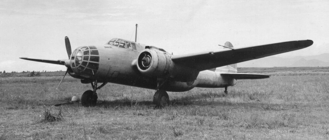 An IJAAF Kawasaki Ki-48 Type 99 twin-engined light bomber (Lily) crashed while apparently making a beeline for the runway at Chiang Mai Airport.1 The 34th Sentai was homebased at Chiang Mai Airport with Ki-48s and it is assumed that the aircraft was returning to homeport; but that is not a certainty. The origin of the flight as well as its purpose are unknown.
The plane had run out of fuel in those last few moments and was force landed without power in a rice paddy, slamming into an irrigation gate structure which demolished the plane. No doubt due at least partly to the lack of fuel, there was no fire. The three occupants were all injured and IJA vehicles took them to hospital. The wreckage was removed by the IJAAF in the week following.
Pastor Meungjai Chaninpan (1887-1969), a resident of Chiang Mai, kept a diary of events, mainly local, during WWII and he recorded in a brief entry the crash of a Japanese plane in Ban Galapo on 05 June 1943. 2 The event is not mentioned in standard references, ie, Umemoto, Shores et al, Ford, Reynolds, Young, Senshi Sosho, nor RTAF histories. The location name, Ban Galapo, was not common knowledge and was identified by Wisarut Bholsithi (email of 1027 10 Jan 2021) citing it as an old name for the current Wat Phothi Mongkhon,3 southeast of the old moated city and near the currently nicknamed “spaghetti” junction (where Thai Highways 11, 1317, 1141, and 3029 intersect).]
 In Tambon Chaisatan, Amphoe Sarapee, Mr. Boon-bpaeng Wangmanee, in his home,4 where he has always lived, recalled at age 11 hearing a loud noise and knew that it had come from the area of Wat Don Chan,5 not Wat Phothi Mongkhon, which was less than 100m from his house. He had not gone to the site, but learned later that a Japanese plane had crashed in the area of the wat. Boon-bpaeng’s house is located about 1,100 m ENE of that crash site. Thus Boonbpaeng confirmed that a Japanese aircraft had crashed in the area, but near Wat Don Chan; and could offer no more details. He did not remember the date.
 Enquiries in the immediate area of Wat Don Chan were unfruitful, until another octagenerian, a Mr. Tong-In Promwichai, father of the current gamnun of Tambon Tasala Moo 2 — back near Chaninpan’s Wat Galapo (Phothi Mongkhon) volunteered information. Tong-in, whose home6 is about 1,300 m NE of the crash site (actually farther away than the first source), said that he had heard a loud noise about 1 pm one day. Aged 12, he had followed adults to the crash site in the rice paddies in front of Wat Don Chai. People there said that the wreckage was that of a two-engined Japanese aircraft which had come down because it had run out of fuel. He saw that it had apparently hit an irrigation system “water gate” and been demolished in the collision; but there had been no fire. He watched as many Japanese had come and taken away three injured people. He said Japanese had removed all the wreckage within a week.
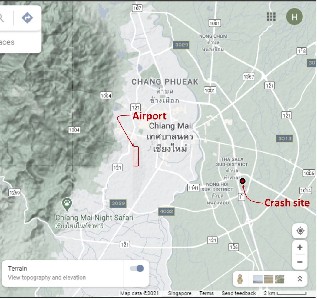
The approximate location of crash site is near the front entrance of Wat Don Chan, about 1,140 m west of where Chanipan had recorded it, ie, at Wat Galapo:
The rice paddies which had been described as the crash site are now obscured by subsequent development, per this Google Earth view dated Sep 2020:
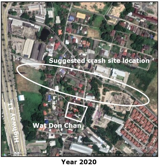
Note: the main axis of the oval titled “Suggested crash site location” above points towards the south end of the Chiang Mai airstrip runway. This assumes that the pilot had abandoned protocol in following the landing pattern and was desperately trying to reach the runway while still airborne.
Hiroshi Umemoto7 does not mention the event.
| First published on Internet | ||
Last Updated on 8 September 2026
- Aircraft was identified by Sinpachi; he indicated on ww2aircraft.net that the aircraft would have been a Ki‑48, a light bomber, in the 34th Sentai. It was the only unit with Ki-48s in the Chiang Mai area at that time.[↩]
- Somchote Ongsakul, Chiangmai 60th Aniversary: Past Present and Future (Chiang Mai: Pinkanakaun Development, nd), p 143[↩]
- N18°45.71 E99°02.60[↩]
- N18°45.696 E99°02.553[↩]
- N18°45.62 E99°01.95[↩]
- N18°46.04 E99°2.56[↩]
- 梅本弘,ビルマ航空戦 (東京:大日本印刷株, 2002) [Umemoto, Hiroshi, Air War in Burma, vol 2 (Tokyo: Dai Nippon, 2002)] [↩]