This page discusses World War II aerial photos taken by the Royal Air Force (RAF) and provided on-line by the Geo-spatial Digital Archive Project (GDAP)1 in its Williams-Hunt Aerial Photograph Digital Collection.2 3
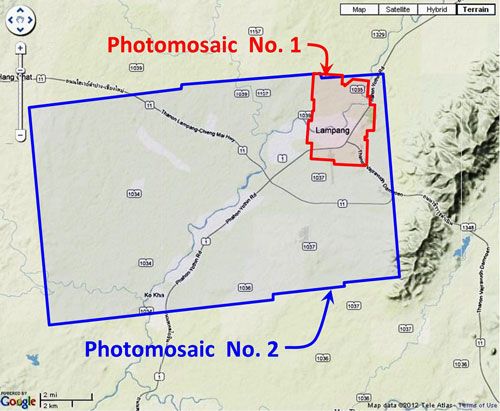
The higher resolution mosaic of Lampang, outlined in red on the site map above and shown below, was assembled with Microsoft’s ICE, a panorama program, using aerial photos dated 07 March 1944:4
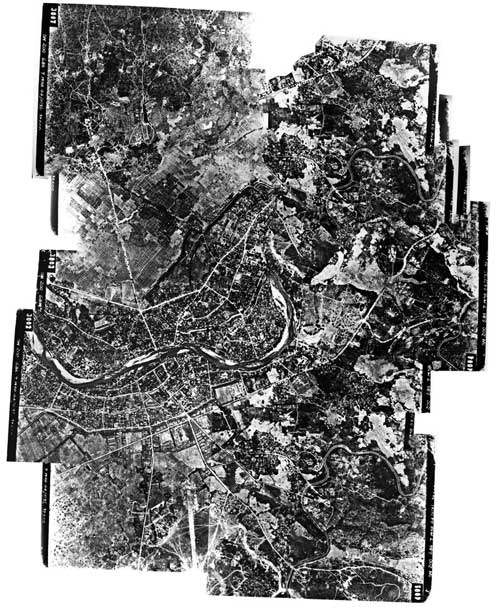
A higher resolution image is available for downloading here.5
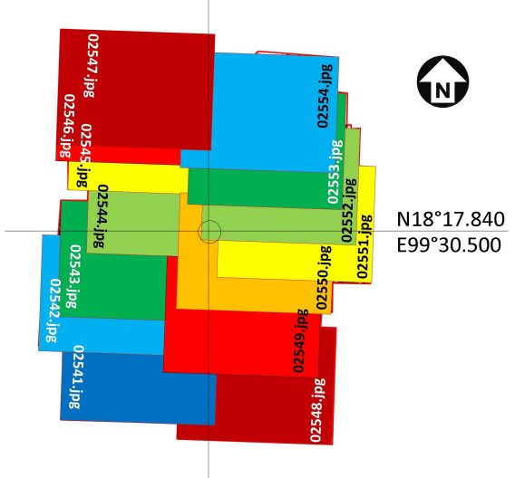
The following GDAP images were used in the above photomosaic:6
02541.jpg
02542.jpg
02543.jpg
02544.jpg
02545.jpg
02546.jpg
02547.jpg
02548.jpg
02549.jpg
02550.jpg
02551.jpg
02552.jpg
02553.jpg
02554.jpg
and can be downloaded in this bundled zip file (5 MB): Lampang Photo Bundle7
Photos were assembled approximately like this, using Microsoft ICE:8
The area around Lampang outlined above in blue was recorded on three USAAF aerial photos taken late in 1945, assembled with Microsoft’s ICE, a panorama program, and reoriented so that its north is page-up. Photos were taken by the 40th Photographic Reconnaissance Squadron, Combat Squadrons of the Air Force World War II, p 188 (offsite link):9
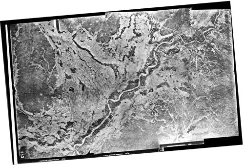
Lampang is located in the upper right quadrant of the mosaic. The airfield with crosswinds runway looks like a small dagger pointed downward. A higher resolution image is available for download here.10
While undated the photos have recently been determined to have been taken late in 1945 (see discussion in footnote below).
The following GDAP images were used in the above photomosaic:11
and assembled approximately like this, using ICE:12
Note that almost all photos in the Williams-Hunt Collection were taken by the RAF. These three however are among a very few in the collection which were taken by the USAAF, specifically the 40th Photographic Reconnaissance Squadron; hence, the “40PR”. Annotations on the negatives read:13
![]()
![]()
![]()
The 40th PRS is noted only briefly in Wikipedia’s 8th Reconnaissance Group (offsite link).
The characters, 5M135, in the annotations are assumed to indicate that the photos were taken in late 1945. The 5 is the year, 1945; the M seems to be a standard designator in aerial photo work; the 135 is the sequence of the order in the 1945 series, which, with that large number, is assumed to be very late in that year.
GDAP, the source of these photos, has asked that the following information be included regarding the aerial imagery shown above:
- Williams-Hunt Aerial Photos Collection
- Original from the School of Oriental and African Studies (SOAS), University of London
- Digital Data from Center for Southeast Asia Studies (CSEAS), Kyoto University
- Digital Archive from Chulachomklao Royal Military Academy (CRMA), Thailand
| First published on Internet | ||
| Photo order reversed to fit chronology | ||
| Converted to WordPress by Ally Taylor | ||
| Updated, author errors & typos corrected | ||
Last Updated on 10 January 2026
- webpage, at link <http://gdap.crma.ac.th/> is no longer available[↩]
- webpage, at link <http://gdap.crma.ac.th/index.php?option=com_content&view=article&id=14&Itemid=3> is no longer available. The collection and its origin are described in detail in:
● Lertlum, PhD, Col Surat, and Dr Elizabeth Moore, Williams-Hunt Aerial Photograph Collection, (undated); available as here linked.
● Moore, Elizabeth, The Williams-Hunt Collection, Sari – International Journal of the Malay World and Civilisation, 27(2)(2009), pp 265-284.
● Periasamy, Makeswary, “A View from the Top”, biblioasia, 5(1) (Apr 2009), pp 38-42.The Williams-Hunt collection has aerial photo coverage on two different dates for Lampang: ((N18°17 E99°28 Location source: Google Earth.[↩]
- “Terrain” map from Nations Online Project: Searchable Map and Satellite View of Thailand using Google Earth Data (link: http://www.nationsonline.org/oneworld/map/google_map_thailand.htm is no longer available). Annotation (red & blue colored items) placed with PhotoShop by author; my ref: \bPROJECT\_MAPS\THAILAND Maps\Williams-Hunt (WH) Aerials\LPG\Lampang photomosaics locatn.jpg[↩]
- Mosaic here oriented so north is top-of-page; my ref: \02370 Other locations\02370 Lampang\WH\aaICE+manual combo-a.jpg[↩]
- my ref: \02370 Other locations\02370 Lampang\WH\ICE+manual combo.jpg[↩]
- The GDAP links are no longer available and the files below, ~300 KB, were downloaded in 2016; my ref: \02370 Other locations\02370 Lampang\WH full size images\. . .jpg[↩]
- my ref: \02370 Other locations\02370 Lampang\WH full size images\WH full size images.zip[↩]
- Drawn by author with Microsoft Publisher; my ref: \02370 Other locations\02370 Lampang\WH\3aa-micro assy.jpg[↩]
- my ref: bPROJECT\_MAPS\THAILAND Maps\Williams-Hunt (WH) Aerials\LPG\LPG 08 ok Lampang City macro\Lampang Composite 8a.jpg[↩]
- my ref: \bPROJECT\_MAPS\THAILAND Maps\Williams-Hunt (WH) Aerials\LPG\LPG 08 ok Lampang City macro\Lampang-Composite-8a.zip[↩]
- The files used here are ~200 KB; refs: \bPROJECT\_MAPS\THAILAND Maps\Williams-Hunt (WH) Aerials\LPG\LPG 08 ok Lampang City macro\ . . .[↩]
- Drawn by author with Microsoft Publisher; my ref: \02370 Other locations\02370 Lampang\WH\macro assy.jpg[↩]
- Extracted from the images numbered 02556.jpg, 02557.jpg, 02558.jpg as linked above; my ref: \02370 Other locations\02370 Lampang\WH\. . . top.jpg[↩]