Activities 1942-forward
04-30 January 1942: The Kong Bin Noi Phasom (Combined Wing) 80, newly stationed at Chiang Rai,1 sent Vought Corsairs and Curtiss Hawk IIIs from Squadrons 22 and 41 to scout and bomb the enemy in various locations in Burma and to patrol the skies over Mae Chaem, Mae Sariang, Khun Yuam, and Mae Hong Son.2
07 January 1942: Sgt Pilot Victor Bargh, a New Zealander, in Royal Air Force (RAF) 67 Squadron, flew a photo-reconnaissance mission from Mingaladon (Rangoon), over Mae Sariang.3
21-22 January 1942: [RAF 113 Squadron] Blenheims bombed Raheng and Mae Sariang on the 21st and 22nd, dropping 6,000 lb of bombs on each target.4
28 February 1942: The Indian Air Force (IAF) made a surprise strafing attack on Mae Sariang.5
January 1944: Allied intelligence issued a so-called “airfield miniature” of Mesarieng airstrip:6
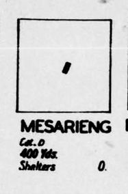
“Cat D” (Category D): “Fair weather only”
“400 Yds” (437 m): Runway length
January 1944: An amendment was issued to an Allied intelligence report:7
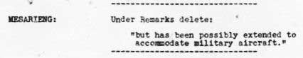
Transcript:
MESARIENG: Under Remarks delete: “but has been possibly extended to accommodate military aircraft.”
Note: the report to which this amendment applies is not available.
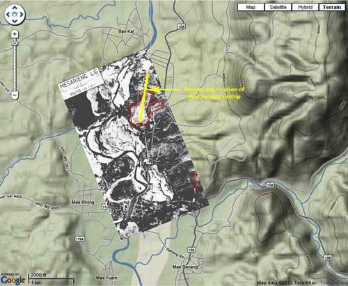
January 1944: This aerial photo, though taken in January, was only published in the April 1944 issue of Airfield Report. While not of raw aerial photo clarity, this image, scanned by Sakpinit Promthep from the original Airfield Report, is a vast improvement over the version previously used here which was a microfilm copy:8
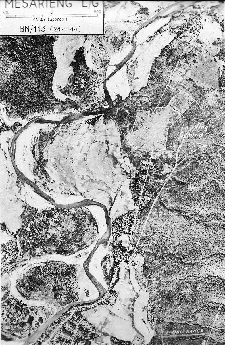
Note that the north arrow in the lower right corner of the photo does not point directly up the page. Placed on a modern map shows its proper orientation and is the basis for the overlay map on page 1 of this article9
February 1944: An Allied intelligence report noted no activity:10

April 1944: The earliest formal Allied intelligence report currently available:11

Transcript:
MESARIENG (HMINELONGYI) (HMAINLONGYI) Landing Ground ¼-inch Map Ref Sheet 94F
-
-
- Coordinates: N18°11 E97°57 (approx.)
- Local Position: In the MENAM YUAM Valley about 1½ miles north of town
- Altitude: About 700 feet above MSL
- Landing Area: Approx 400 x 400 yards with clearing at the northeast corner giving a max run of 600 yards in a NNE-SSW direction.
- Surface: Cleared scrub.
- Serviceability: Liable to become unserviceable after heavy rains.
- Installations: One small hangar.
- Communications:
- Rail: No rail available.
- Road: Road north to KHUNYAM and south to MESARIENG thence track to outlying villages.
- River: YUAM running due south has rapids.
- Landmarks: SALWEEN River runs north to south about 20 miles to the west
and has a distinctive bend slightly north of due west. The Landing Ground
lies in a valley running parallel to SALWEEN Valley. YUAM River within 200
yards west of the site.
-
Compiled from information available up to 30 Apr 44.
Another section of that report in April 1944 made an observation significant for the entire history of the Mae Sariang airstrip during WWII:12
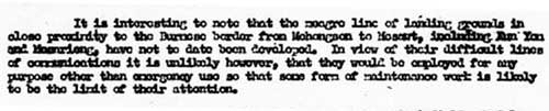
Transcript:
It is interesting to note that the meagre line of landing grounds in close proximity to the Burmese border from Mae Hong Son to Mae Sot, including Khun Yuam and Mae Sariang, have not to date been developed. In view of their difficult lines of communication it is unlikely however, that they would be employed for any purpose other than emergency use so that some form of maintenance work is likely to be the limit of their attention.
July 1944: The airstrip with some detail was included in an Allied intelligence listing of airports:13
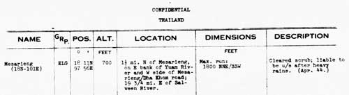
Transcript:
-
- Name: Mesarieng (N18 E101)
- Group: ELG [Emergency Landing Ground]
- Position: N18°11 E97°56
- Altitude: 700 feet
- Location: 1½ miles north of Mesarieng, on east bank of Yuam River and west side of Mesarieng-Dha Khom Road;19¾ miles east of Salween River.
- Dimensions: Maximum run: 1800 feet NNE/SSW
- Description: Cleared scrub; liable to be u/s [unserviceable] after heavy rains (Apr 44)
November 1944: Another Allied intelligence formal report on the Mae Sariang airstrip:14
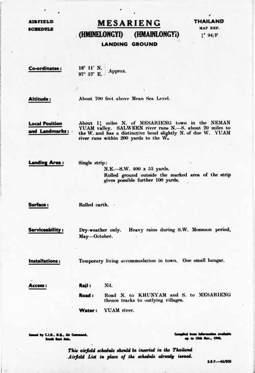
Transcript:
MESARIENG (HMINELONGYI) (HMAINLONGYI) Landing Ground ¼-inch Map Ref Sheet 94/F
-
-
- Coordinates: N18°11 E97°57 (approx.)
- Altitude: About 700 feet above MSL
- Local Positions and Landmarks: About 1½ miles north of Mesarieng town in the NEMAN YUAM valley. SALWEEN river runs north-south about 20 miles to the west and has a distinctive bend slightly north
of due west. YUAM River within 200 yards west of the site. - Landing Area: Single strip:
- Northeast-southwest 400 x 55 yards
- Rolled ground outside the marked area of the strip gives possible further 100 yards.
- Surface: Rolled earth.
- Serviceability: Dry-weather only. Heavy rains during southwest monsoon period, May-October.
- Installations: Temporary living accommodation in town.
One small hangar. - Access:
- Rail: Nil
- Road: Road north to KHUNYAM and south to MESARIENG thence tracks to outlying villages.
- River: YUAM running due south has rapids.
-
31 December 1944: The last formal Allied intelligence report on the Mae Sariang airstrip:15
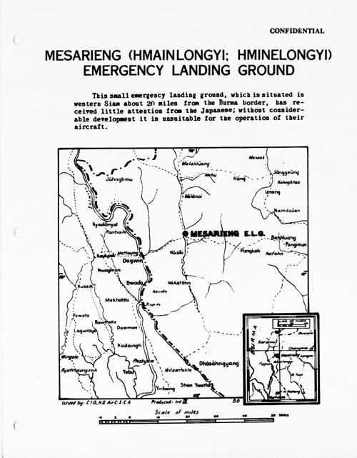
Transcript:
This small emergency landing ground, which is situated in western Siam about 20 miles from the Burma border, has received little attention from the Japanese; without considerable development it is unsuitable for the operation of their aircraft.
The more familiar Allied intelligence report format:16
Transcript:
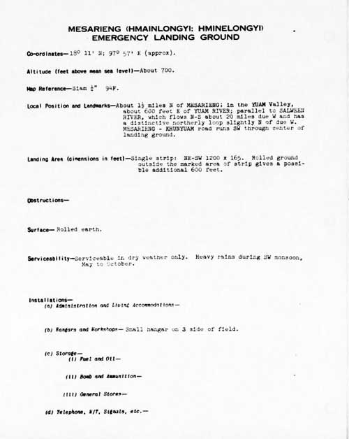
MESARIENG (HMAINLONGYI; HMINELONGYI) EMERGENCY LANDING GROUND
-
-
- Co-ordinates — N18°11 E97°57 (approx.)
- Altitude (feet above MSL) — about 700
- Map Reference — Siam ¼” 94F
- Local Position and Landmarks — About 1½ miles north of MESARIENG; in the YUAM Valley, about 600 feet east of YUAM RIVER; parallel to SALWEEN RIVER, which flows N-S about 20 miles due west and has a distinctive northerly loop slightly north of due west.
MESARIENG-KHUNYUAM road runs southwest through center of landing ground. - Landing Area (dimensions in feet) — Single strip: NE-SW. 1200 x 165. Rolled ground outside the marked area of strip gives a possible additional 600 feet.
- Obstructions — [blank]
- Surface — Rolled earth
- Serviceability — Serviceable in dry weather only. Heavy rains during southwest monsoon May to October.
- Installations —
. (a) Administration and Living Accommodations —
. (b) Hangars and Workshops — Small hangar on three side of field.
. (c) Storage —
. (i) Fuel and Oil —
. (ii) Bomb and Ammunition —
. (iii) General Stores —
. (d) Telephone, W/T, Signals, etc —
. (e) Night Landing —
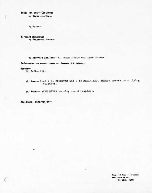
. (f) Water — - Aircraft Dispersal —
. (a) Dispersal Areas —
. (b) Aircraft Shelters — [deadend reference] - Defenses — see current report on ‘Japanese AA Defenses’
- Access —
. (a) Rail — Nil
. (b) Road — Road N to KHUNYUAM and S to MESARIENG,
. thence tracks to outlying villages.
. (c) Water — YUAM RIVER running due S (rapids).
-
Compiled from information available up to 31 Dec 1944.
05 March 1945: According to Mr Porm Sootsukon (a civil servant in Mae Hong Son) around 1235 hours on 05 Mar 1945, a single two-engined Allied Forces plane from the direction of Burma flew over the Mae Sariang governor’s official resident and then went on . . . . It was assumed that the intent . . . was just psychological in support of the Free Thai movement.17
20 March 1945: Three versions of an air crash in Mae Hong Son Province:
- From Shores:18
. . . the fighter squadrons of the 2nd Air Commando Group flew to northern Thailand to strafe fields at Chiengmai and [Phrae],19 which were being used by the Japanese as air staging posts. Near Chiengmai Capt William C Marshall of the 1st Command Squadron encountered a small single-engined aircraft which he identified as a ‘Stinson-type’ and shot it down. It was in fact a civilian Fairchild 24 of the Aerial Transport Company of Thailand,20 which unfortunately arrived at exactly the same time as the US fighters.
- From Boonserm Satrabhaya:21
The pilot who flew the Norseman regularly from Chiang Mai to Mae Hong Son before the war, was a Mr Puai. Local people called the aircraft “Mr Puai’s aircraft”.
During the war, Mr Puai was shot down by an Allied aircraft while flying to Mae Sariang. The company and local people as well as his family were saddened to lose a good and friendly pilot.
- From an interview, distorted by time, by Cherdchay Chomtawat:22
After [?] the war, there was a Thai mail plane (for letter delivery from Mae Hong Son to Amphoes Khun Yuam and Mae Sariang). This plane flew three times a month. One day this mail plane encountered British aircraft flying in the opposite direction. The British pilots saw the Thai pilot and mistook him for a Japanese. Later the mail plane encountered 40 – 50 British planes, two of which turned and attacked. The mail plane caught fire and crashed in the Ban Mae Surin area.
Villagers went to see the plane crash site and found four dead bodies. They included the pilot, Mr. Pui (surname unknown); a pilot assistant (name unknown); a Japanese soldier in uniform; and the superintendent of Mae Hong Son. The next day, the bodies were ceremonially cremated. The remains of the Japanese soldier were taken to Japan. There were some burnt banknotes (about 10,000 baht), two pistols, and other belongings in the crashed plane which district officers took.
While vague as to location, Shores provided a precise date for the event, and, while wildly inaccurate as to date, Cherdchay’ interviewee correctly identified the crash site, ie, Mae Surin, which is just north of Khun Yuam.23
April 1945: Amendments to Airfield Lists: SIAM: Amendment List No. 1 (1945):24
![]()
Transcript:
MESARIENG L/G: Landing Area: Amend to read:
Single strip: NE-SW, 1000 x 55 yards approx.
Apparently this item amends the report dated 31 December 1944 above.
??? 1945: . . . [apparently in late 1945] seven planes, guns firing, dropped 24 bombs, which fell in a rice field behind Mae Sariang City Hall. Four failed to explode. Nobody died.25
Through 15 August 1945 (end of war): For record purposes, as of March 2025, good quality World War II era aerial photographs of the Mae Sariang area have not been found.
February 1971: Air America’s listing26 for the field is generally consistent with earlier details:
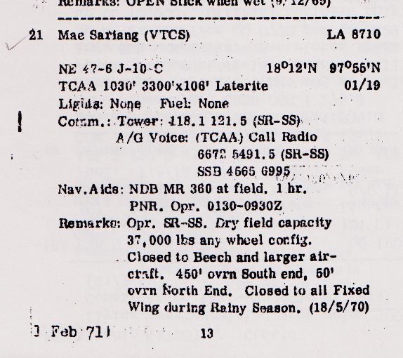
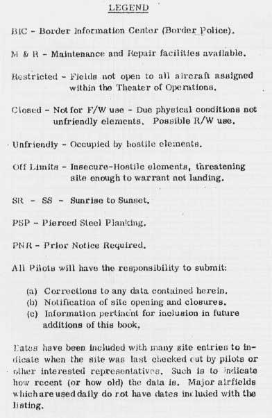
Use the Legend if needed to interpret the data27
1977: View of the condition of the airstrip by a member of the 1977 Japanese team searching for IJA remains:
. . . on the eastern side of the “airfield.” I say “airfield”: it is only a narrow field where the red clay is raked and flattened. All around seems to be a second-growth forest of teak; weeds and bushes are grown out to about one or two meters.28
1990: The movie, Air America (offsite link), released in 1990, used the airstrip at Mae Sariang in some of its scenes.29
1992 / 2007(?): Royal Thai Survey Department Map No. 4545 II, Title: Mae Sariang:
7017 Series (Mar 1992): information is out-of-date.
7018 Series (2007): this is the current series and is controlled by copyright.
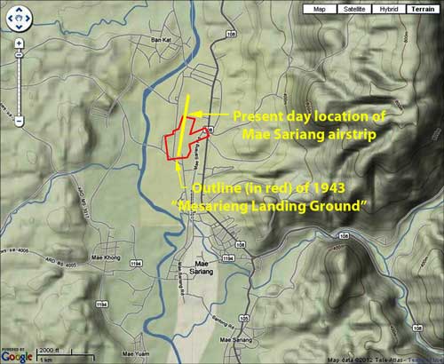
03 April 2003: Google Earth view of Mae Sariang airstrip area30
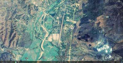
An overlay of a 1943 image of the airstrip on a recent topographic map of the area which includes the current airstrip shows that the present-day runway is a direct extension of the earlier runway:31
AIRPORT CURRENT STATS:32
Name: Mae Sariang Airport – VTCS4
Coordinates: N18°11.3 E97°55.7
Runway Heading: 01/19
Length: 1,000 meters
Slope: none
Elevation: 750′
Obstructions: Clear.
The Thai Flying Club webpage for Mae Sariang Airport (offsite link) features two excellent oblique photos of the site; unfortunately, directions of photo views are less than clear: the smaller oblique photo (bottom left) dated 2003 looks south per Club comment; but the larger oblique dated 2007 looks north (note that the near end of the runway is labeled “01”). The webpage incorrectly identifies the river just to the west as the Salween; in actual fact, it is the Yuam. The Salween is about 27 km west.
The Thai Flying Club’s two oblique photos of the runway also show that it was paved sometime between 2003 and 2007.
| First published on Internet | ||
| Added many page images; tried to standardize style; smoothed. | ||
| Substituted improved aerial photo from Airfield Report. | ||
| Converted to WordPress by Ally Taylor | ||
| Updated, author errors & typos corrected | ||
Last Updated on 20 February 2026
- Young, ibid, p 185.[↩]
- บระวัติกองทัพอากาศไทย พ.ศ.๒๔๕๖ ๒๕๒๖ กองทัพอากาศ พุทธศักราช ๒๕๒๖, [History of the Thai Air Force, 1913-1983 (Bangkok: Royal Thai Air Force, 1983)], p 308.[↩]
- Frances, Neil, Ketchil (Masterson NZ: Wairarapa Archive, 2005), p 68. [My ref: Aerial N186].[↩]
- Shores, Christopher & Brian Cull, with Yasuho Izawa, Bloody Shambles vol I (London: Grub Street, 2007), p 260 [My ref: BSI:07 260, 21-22 Jan 42]. Also Young, ibid, p 186 [My ref: Aerial N 186]. Corroborated by Pearson, Michael, The Burma Air Campaign 1941-1945 (South Yorkshire: Pen & Sword, 2006), pp 33‑34.[↩]
- Information from The Official History of the RIAF per Jagan Pillarisetti email of 29 Jun 2008 00:11.[↩]
- Airfield Report No. 18, Jan 1944, Airfield Miniatures, unnumbered page (USAF Archive microfilm reel A8055 p 422).[↩]
- Airfield Report No. 18, Jan 1944, p 37 (USAF Archive microfilm reel A8055 p 476).[↩]
- Airfield Report No. 21, Apr 1944, unnumbered page: scan provided by Sakpinit Promthep by email of 10:26 15 Oct 2021 (previous version of lesser quality was from USAF Archive microfilm reel A8055 p 646). [Current image added 22 Oct 2021].[↩]
- Aerial photo above overlaid on a “Terrain map” from Nations Online Project: Searchable Map and Satellite View of Thailand using Google Earth Data (accessed 20 May 2012; but no longer on-line). Matching and annotations by author using Microsoft Publisher.[↩]
- Airfield Report No. 19, Feb 1944, p 24 (USAF Archive microfilm reel A8055 p 524).[↩]
- Airfield Report No. 21, Apr 1944, no page number (USAF Archive microfilm reel A8055 p 671).[↩]
- ibid, p 4, “Review of Airfield Development in Thailand”, (USAF Archive microfilm reel A8055 p 618).[↩]
- Provisional Airfield List, Report No. 3, 25 Jul 1944, p 63 (USAF Archive microfilm reel A1284 p 1413).[↩]
- Airfield Report No. 28, Nov 1944, unnumbered page (USAF Archive microfilm reel A8055 p 1080).[↩]
- Siam (Thailand) List of Airfields and Seaplane Stations (Washington: Ass’t Chief of Air Staff, Intelligence, 1945), unnumbered page (USAF Archive microfilm reel A1285 p 1241).[↩]
- ibid, unnumbered pages (USAF Archive microfilm reel A1285 pp 1242, 1243).[↩]
- รายงาน การ สําร จอขุดค้น – ตาม โครงการ คึกษาเชิงอนรักษ์แหล่ง ฝังศพทหารญี่บุน-สมัย สงครามโลกครั้งที่ 2 จังหวัดแม่ฮ่องสอน – หัางหุ้นส่วนจํากัดเฌอ กรีน – เสนอต่อ – จังหวัดแม่ฮ่องสอน – สำนักงานโบราณคดีและพิพิธภณฑสถาน แห่งชาติที่6 ใชียงเหม่ (1999) Report on Archaeological Research for the Japanese Soldiers Burial Project World War II Era – Mae Hong Son Province (Chiang Mai: Green Tree, LLP, Ltd, submitted by / for Mae Hong Son Province Archaeology & National Museum Office 6, Chiang Mai, 1999), p 117. Hereafter: Report on Archaeological Research.[↩]
- Quoted from Shores, Christopher, Air War for Burma [“The Third . . . Volume of the Bloody Shambles Series”] (London: Grub Street, 2005), p 342.[↩]
- Shore identified Phroe: that name does not appear on Thai maps. Similar in name in the area were Phrao, Phayao, and Phrae. Only the last had an air facility (N18°08 E100°10), 60 km ESE of Lampang and shown on US Army Series L509, NE 47-7 “Lampang”.[↩]
- “Stinson-type” aircraft: the Stinson SR-series was popular before the war per Wikipedia’s Stinson Reliant (offsite link) but that reference does not list any models in Thailand.
Mentioned in a following version: The Noorduyn Norseman. “. . . it looked surprisingly like the Stinson SR 10.” per RCGroups.com‘s Noorduyn U-64 Norseman (offsite link).
However, “Until 1940, the Noorduyn company had sold only 17 aircraft in total, primarily to commercial operators in Canada’s north and to the Royal Canadian Mounted Police.” per Wikipedia‘s Noorduyn Norseman (offsite link).
On the other hand, Thai Aviation Net‘s Thai Civil Register and Royal Thai Air Force (offsite links) listings record no Norseman or Stinson models registered before the war; but the civil register does record a Fairchild 24 exported to Thailand 04 Oct 1940 (that particular aircraft survived at least until 1955) and its Air Accidents (offsite link) list records a Thai Air Force Fairchild 24 shot down in Mar 1945 by a USAAF P-51.
It would appear that the aircraft could only have been a Fairchild 24 as Shores asserts.[↩]
- บุญเสิม สาตราภัย เชียงใหม่กับภัยทางอากาศ (กรุงเทพฯ: วิญฌูชน, 2003) [Boonserm Satrabhaya, Chiang Mai and the Air War (Bangkok: Winyuchon, 2003)], p 136. No date for incident was provided.[↩]
- Mr Boon-ton Sriwichai:((Interviewee No. 8 in เชิดชาย ชมธวัช, บ้อมูลเส้นทางเดินทัพทห ารญี่ปุ่น ในอำเภอบุนยวม สงครามมหาเอเชียบูรพา (สงครามโลกครั้งที2) จดทำโดย พันตำรวจโท [Chomtawat, Cherdchay, Information about Japanese soldiers traveling through Amphur Khun Yuam in World War 2 [15 Interviews] (self published, undated, but before 2004)], unnumbered page.[↩]
- Also presented at 20 March 1945 entries on Mae Hong Son page[↩]
- Airfield Report No. 33, Apr 1945, p 11 (USAF Archive microfilm reel A8056 p 174).[↩]
- Report on rchaeological Research, p 109 [My ref: CMMR 109].[↩]
- Air Facilities Data Thailand 432 (?: Air America?, Feb 1971), p 31[↩]
- ibid, p 6
- Journal, p 455.[↩]
- Thai Flying Club – Mae Sariang Airport (offsite links).[↩]
- Google Earth view of Mae Sariang airstrip area, image data dated 03 Apr 2003; accessed 30 Apr 2012.[↩]
- Aerial photo dated 24 Jan 1944, in Airfield Report No. 21 (Chief Intelligence Officer, Headquarters, Air Command, South East Asia, Jan 1944), unnumbered report page (USAF Archive Reel B8055, p 0646); and overlaid on “Terrain map” from Nations Online Project: Searchable Map and Satellite View of Thailand using Google Earth Data, accessed 20 May 2012; but no longer on-line. Matching and annotations by author using Microsoft Publisher.[↩]
- Thai Flying Club: ibid.[↩]