Tha Pai Bridge1
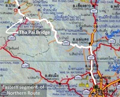
The bridge over the River Pai2 (Google Maps link) is often, but erroneously, presented as built by the Imperial Japanese Army (IJA) during WWII. It is also known as “the Bridge over the River Pai”, “The World War II Memorial Bridge”, “The Old Iron Bridge at Pai”, etc. Preliminary information by the author about the Tha Pai3 Bridge4 is currently available at The Pai Bridge (offsite link).
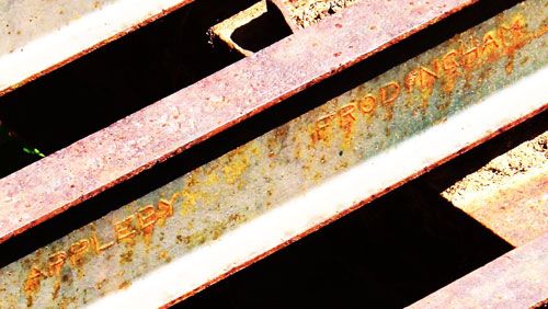
The photo below is taken from a detailed examination of the Pai bridge which will be included here at a future time: in the photo is the name of one of the steel manufacturers for the Bailey Bridge which forms the northerly-most span of the Pai bridge. The San Khayom bridge has steel members from the same manufacturer:5
| First published on Internet | ||
| Appleby-Frodingham photo added | ||
| Converted to WordPress by Ally Taylor | ||
| Updated, author errors & typos corrected | ||
Last Updated on 20 February 2026
- my ref: \02313 1095 088 Pai bridge\Maps\Location map.jpg[↩]
- N19°17.845 E98°27.884[↩]
- ท่าผา, ie, Tha Pai, (both per RTSD map 4647 I) is the name of the village at the southeast end of the bridge[↩]
- Map is extracted from แผนที่ทางหลวงประเทสไทย Scale 1:1,600,000 (กรุงเทพมหานคร:กรมทางหลวง, 2009) [Road Map of Thailand, Scale 1:1,600,000 (Bangkok: Department of Public Highways, 2009)] (foldout map). Annotations are by author. Routes used by retreating IJA forces are here assumed to approximate currently existing roads.[↩]
- Extract from CIMG2482 of 11 Feb 2008; photo has been enhanced to improve legibility of manufacturer’s name. My ref: \02313 1095 088 Pai bridge\Maps\Appleby-Frodingham.jpg[↩]