This page discusses World War II aerial photos taken by the Royal Air Force (RAF) and provided on-line by the Geo-spatial Digital Archive Project (GDAP) (website no longer active)1 in its Williams-Hunt Aerial Photograph Digital Collection (website no longer active).
The Williams-Hunt collection has aerial photo coverage on two different dates for Chiang Mai:2
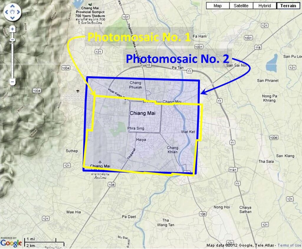
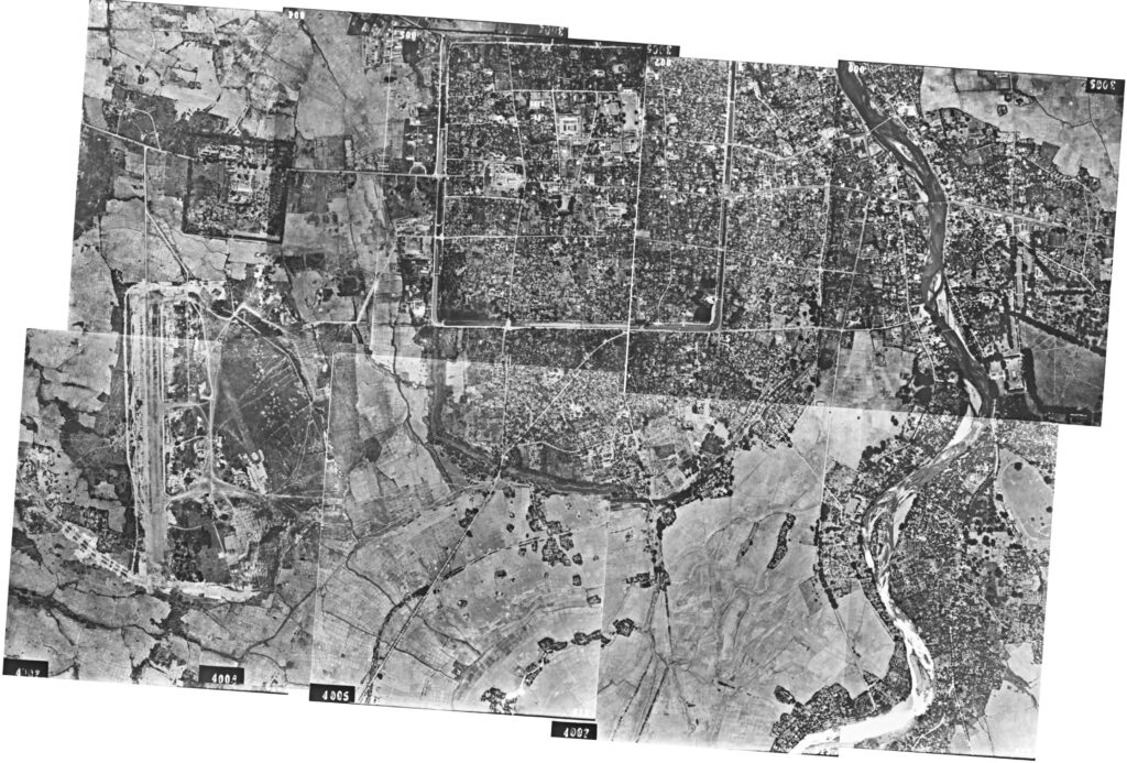
Photomosaic No. 1
The area around Chiang Mai outlined above in yellow was recorded in sixteen RAF aerial photos taken on 03 April 1944. Though all the aerial photos could not be joined in one pass with Microsoft ICE (Image Composition Editor), that program was useful in helping fit up various adjoining images manually.3 In addition, to simplify the stitching process, since there was extensive overlapping, some file images were not used: only eight of the sixteen total photos were finally used. Mosaic has been oriented so that north is page-up:4
Higher resolution images of this mosaic may be downloaded here:
- The mosaic shown directly above, 1,207 KB5
- Mosaic overlaying Google Earth sat view, 16,667 KB,6 not shown.
- Mosaic overlaying Mueang map, 10,152 KB,7 not shown
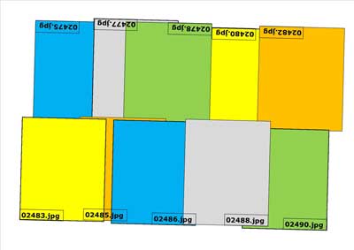
The individual images used in the above photomosaic were ~1024 KB. Since their source, GDAP, apparently no longer maintains a website offering these images, copies of those images in size ~2500 KB are provided below:
02475.zip
02477.zip
02478.zip
02480.zip
02482.zip
02483.zip
02485.zip
02486.zip
02488.zip
02490.zip
They were arranged approximately like this:8
Photomosaic No. 2
A similar mosaic, as outlined in blue on the site map above, had been earlier assembled by Allied intelligence on 15 November 1943:9
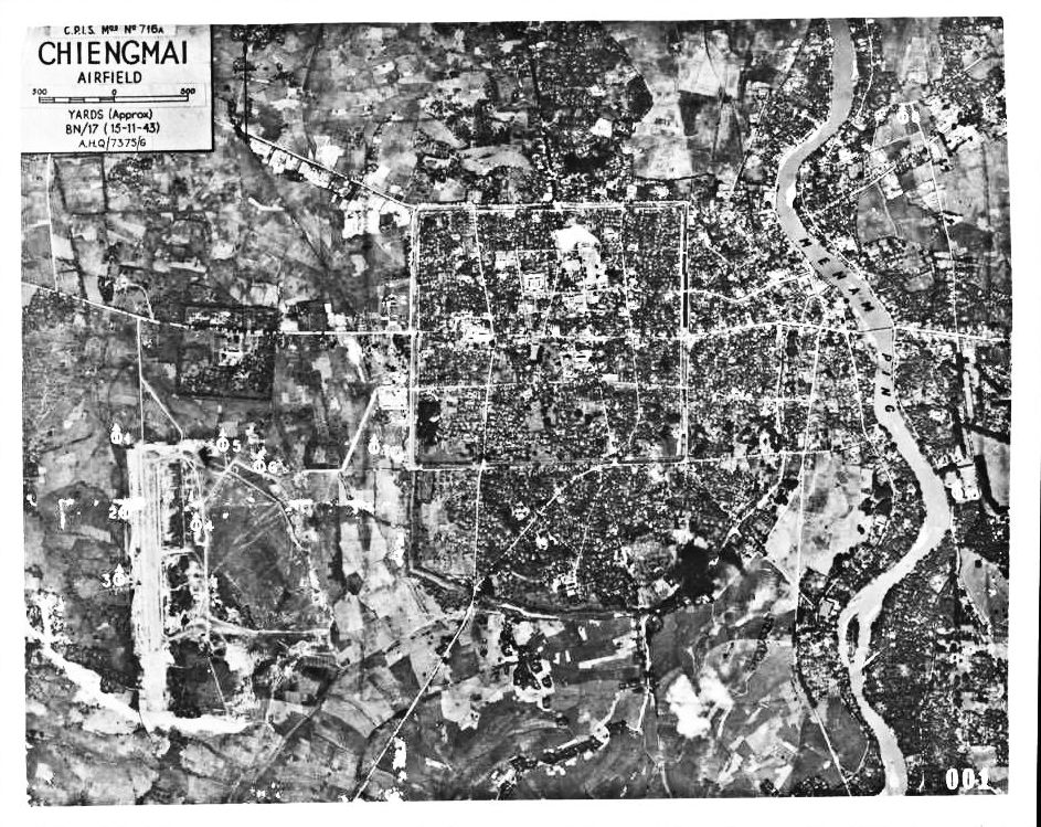
This image, 02474.jpg, the mosaic as completed by Allied intel, was downloaded from the GDAP website. The image at 185 KB is available for download here.
GDAP, the source of these photos, asked that the following information be included regarding the aerial imagery shown above:
- Williams-Hunt Aerial Photos Collection
- Original from the School of Oriental and African Studies (SOAS), University of London
- Digital Data from Center for Southeast Asia Studies (CSEAS), Kyoto University
- Digital Archive from Chulachomklao Royal Military Academy (CRMA), Thailand
| First published on Internet | ||
| Converted to WordPress by Ally Taylor | ||
| Updated, author errors & typos corrected | ||
Last Updated on 7 January 2026
- screen capture, 2012:
 [↩]
[↩] - N18°47.30 E98°59.15 (Google Earth fix on apparent center of town.) “Terrain” map from Nations Online Project: Searchable Map and Satellite View of Thailand using Google Earth Data (website no longer active). Annotation (red & blue colored items) placed with PhotoShop by author; my ref: \02200 Chiang Mai city\MAPS, locale\WH aerials\Locatn overlays small x2.jpg.[↩]
- While Image Composition Editor (ICE) is no longer supported by Microsoft, it is still functional and I found it extremely useful. It is still available for downloading by querying the Wayback Machine (offsite link) with “http://research.microsoft.com/en-us/um/redmond/groups/ivm/ice/” and selecting any capture for 2012[↩]
- My ref: \bPROJECT\_MAPS\THAILAND Maps\Williams-Hunt (WH) Aerials\CNX\CNX realigned OK\CNX composite 1 ok\CNX Composite01 componentsz.pub\CNX Composite01tilt-75colorall.jpg[↩]
- Available as a zip file. My ref: \bPROJECT\_MAPS\THAILAND Maps\Williams-Hunt (WH) Aerials\CNX\CNX realigned OK\CNX composite 1 ok\CNX Composite01 componentsz.pub: CNX Composite01tilt-75colorall.jpg[↩]
- Available as a zip file. My ref: bPROJECT\_MAPS\THAILAND Maps\Williams-Hunt (WH) Aerials\CNX\CNX overlays\CNX-WH over GE markup UPDATE.jpg[↩]
- Available as a zip file. My ref: \bPROJECT\_MAPS\THAILAND Maps\Williams-Hunt (WH) Aerials\CNX\CNX realigned OK\CNX composite 1 ok\Mueang-photo match.jpg[↩]
- Drawn with Microsoft Publisher by author; my ref: bPROJECT\_MAPS\THAILAND Maps\Williams-Hunt (WH) Aerials\CNX\CNX realigned OK\CNX composite 1 ok\CNX Composite01 componentsz.pub:CNX Composite01 componentszzz.jpg.[↩]
- Allied-generated mosaic was oriented so that its north is page-up; my ref: \02200 Chiang Mai city\MAPS, locale\WH aerials\CNX 431115 02474 SUMMARYe.jpg[↩]