This page discusses World War II aerial photos taken by the Royal Air Force (RAF) and provided on-line by the Geo-spatial Digital Archive Project (GDAP)1 in its Williams-Hunt Aerial Photograph Digital Collection.2
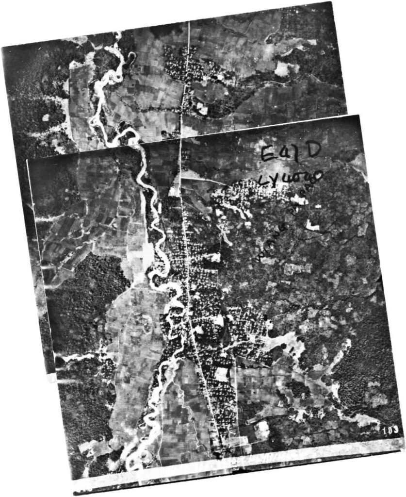
That collection has a single set of aerial photos for Pa Pao,3 dated 25 October 1944:4
The two-photo aerial photomosaic:5
A higher resolution image is available for download here.
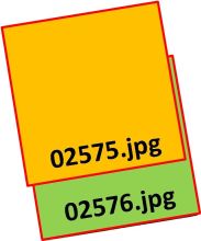
The following GDAP images were used in the above photomosaic:6
and assembled approximately like this, using Microsoft ICE:9
The handwritten note at the upper right in the overlapping photo can be enhanced to become legible:
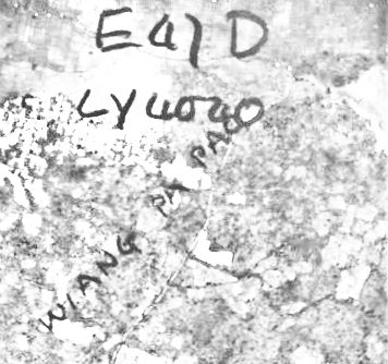
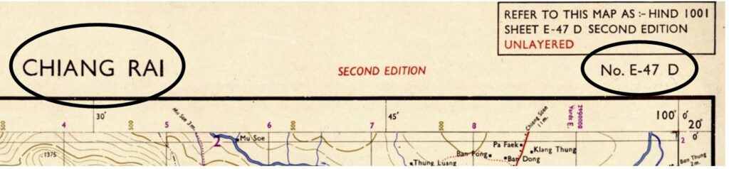
The first line is E47D, which refers to Survey of India map titled, “Chiang Rai”:
The next handwritten line reads “LY4040” referring first to the grid designation, “LY” at the left of the map. Then, on the right, inside the horizontal and vertical coordinate lines, the map coordinates both coincidentally numbered “4” bracket “Wiang Pa Pao”:
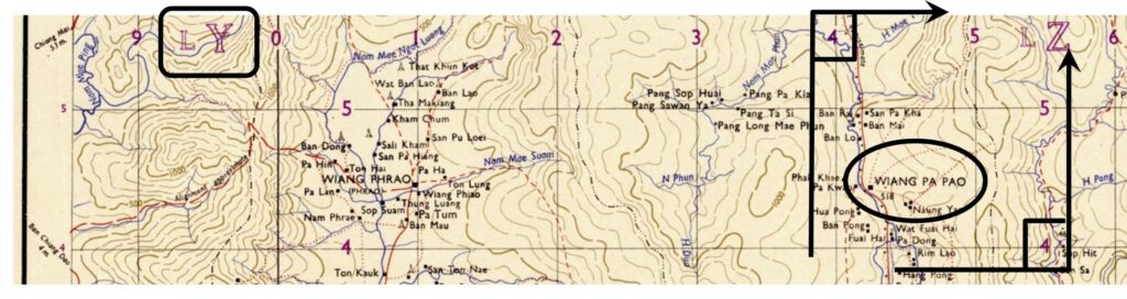
Unfortunately, the aerial photo interpreter did not look down the left side of the page: the vertical grid section changes from LY to LZ at vertical line “0”:
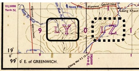
So the handwritten note should have read “LZ4040″. Further, there is the irony that instructions at the bottom right of the map actually uses Wiang Pa Pao as an example for how to locate points on the chart:
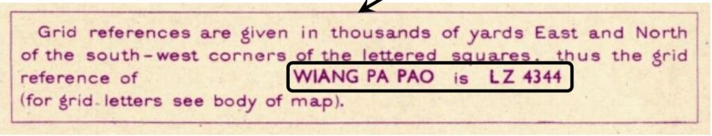
While the handwritten note generalized the coordinates as “4040”, the example went to two decimals, “4344”, for the location. Practically speaking, with the limits to the accuracy of navigation in the 1940s, “4040” might well have sufficed.
GDAP, the source of these photos, has asked that the following information be included regarding the aerial imagery shown above:
- Williams-Hunt Aerial Photos Collection
- Original from the School of Oriental and African Studies (SOAS), University of London
- Digital Data from Center for Southeast Asia Studies (CSEAS), Kyoto University
- Digital Archive from Chulachomklao Royal Military Academy (CRMA), Thailand
| First published on Internet | ||
| Converted to WordPress by Ally Taylor | ||
| Updated, author errors & typos corrected | ||
Last Updated on 20 February 2026
- webpage, at link <http://gdap.crma.ac.th/>, is no longer available[↩]
- webpage, at link <http://gdap.crma.ac.th/index.php?option=com_content&view=article&id=14&Itemid=3>, is no longer available. The collection and its origin are described in detail in:
● Lertlum, PhD, Col Surat, and Dr Elizabeth Moore, Williams-Hunt Aerial Photograph Collection, (undated); available as here linked.
● Moore, Elizabeth, The Williams-Hunt Collection, Sari – International Journal of the Malay World and Civilisation, 27(2)(2009), pp 265-284.
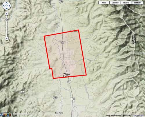
● Periasamy, Makeswary, “A View from the Top”, biblioasia, 5(1) (Apr 2009), pp 38-42.[↩] - N19°21.50 E99°30.30; source: Google Earth fix on apparent center of town.[↩]
- “Terrain” map from Nations Online Project: Searchable Map and Satellite View of Thailand using Google Earth Data (link is no longer available). Annotation (red & blue colored items) placed with Microsoft Publisher by author; my ref: \02370 Other locations\02370 Pa Pao\WH\Pa Pao aerial location map1.jpg[↩]
- Photos were assembled using Microsoft’s ICE, a panorama program, with result re-oriented so that north is top-of-page; my ref: \02370 Other locations\02370 Pa Pao\WH\13 Pa Pao-e-tilt.jpg.[↩]
- The files used here were ~200 KB.[↩]
- my ref: \bPROJECT\_MAPS\THAILAND Maps\Williams-Hunt (WH) Aerials\LPG\LPG 13 Pa Pao ok\a02575a.jpg[↩]
- my ref: \bPROJECT\_MAPS\THAILAND Maps\Williams-Hunt (WH) Aerials\LPG\LPG 13 Pa Pao ok\a02576a.jpg[↩]
- Drawn by author with Microsoft Publisher; my ref: \02370 Pa Pao\WH\Pa Pao assembly-red.jpg[↩]