Aerial Photomosaics based on
the Williams-Hunt Photo Collection
This page discusses the assembly of photomosaics from World War II aerial photos taken by the Royal Air Force (RAF)1 and provided on-line by the Geo‑spatial Digital Archive Project (GDAP) (link2 no longer active 18 Dec 2025) in its Williams-Hunt Aerial Photograph Digital Collection (link3 no longer active 18 Dec 2025). The collection and its origin are described in detail in:
- Lertlum, PhD, Col Surat, and Dr Elizabeth Moore, Williams-Hunt Aerial Photograph Collection.zip.
- Moore, Elizabeth, The Williams-Hunt Collection.zip Sari – International Journal of the Malay World and Civilisation, 27(2)(2009), pp 265-284.
- Periasamy, Makeswary, A View from the Top.zip, biblioasia, 5(1) (Apr 2009), pp 38-42
The source of these photos asked that the following information be included regarding the aerial imagery treated below:
- Williams-Hunt Aerial Photos Collection
- Original from the School of Oriental and African Studies (SOAS), University of London
- Digital Data from Center for Southeast Asia Studies (CSEAS), Kyoto University
- Digital Archive from Chulachomklao Royal Military Academy (CRMA), Thailand4
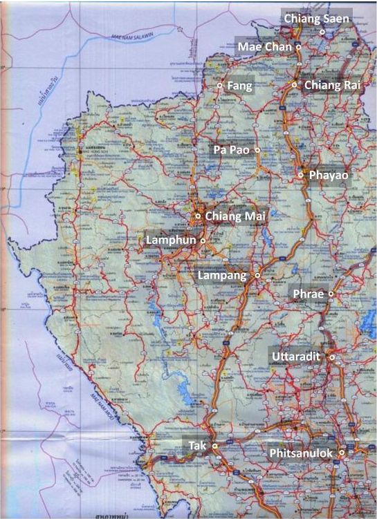
In northwest Thailand, the following areas were covered by the GDAP website (now discontinued):5
Actually, this extends beyond northwest Thailand proper, but since I have already assembled photomosaics for these locations, I have included them. The full geographic range of coverage of the collection was formerly at the GDAP’s Williams-Hunt Aerial Photograph Digital Collection Location webpage (no longer active). Much additional aerial photo coverage from WW2 is available from The U.S. National Archives and Records Administration (NARA)
The photomosaics were initially put together manually in 2009, using in each case, a Google Earth view of the area as a backdrop to ease alignment and lessen “creeping” errors. Col Surat Lertlum, Program Head, Computer Science Program at Chulachomklao Royal Military Academy, cautioned:6
If you do not use RS image processing or GIS software to geo-reference each image first before creating the mosaic, the result will accumulate error and distortion from each photo, and finally it will be more difficult to geo-reference your mosaic to a map.
In 2012, the photomosaics were redone using Microsoft ICE.7 That program is not the answer to Col Lertlum’s comment above; and care must still be used in applying the program. However, the use of the ICE program can make the process of assembling, or “stitching” individual photos together manually, immensely easier, without getting involved in RS image processing or GIS software.
Some suggestions about the use of Image Composition Editor (ICE):
Brightness and contrast in aerial photos should be enhanced before assembling them — it makes it easier to proof ICE solutions; or to assemble them manually.
First, put the images together manually in a program such as Microsoft Publisher or Adobe PhotoShop. Not often, but occasionally, ICE will go wildly astray, and the rough-in will provide a control.
The titles of the images must be in a numerical or alphabetical order: it would appear that ICE uses that order in assembling the images.
ICE recognizes margins of photos and automatically deletes them from its processing; ie, no cropping is necessary.
If an image. for whatever reason, is out-of-place, remove it from the set sent to ICE. Reprocess the smaller set or resulting two sets. Then send the resulting stitched up image plus the errant image together into ICE for processing. If the particular image still is not properly located, insert it manually using Publisher or PhotoShop.
If the mosaic has more than one row or column of images, process one row or column of images at a time. Then join the resulting stitched up products from ICE.
ICE photomosaics seem to be of slightly lower resolution than the individual photos.
No provision is available in ICE for designating ground control points, which is Colonel Lertlum’s concern: hence, the mosaics may not accurately represent what is “on the ground”. Minor errors in one photo will be passed to adjacent photos. Further, WWII aerial photos are the product of a technology 70 years ago — aerial and now satellite photo equipment are orders of magnitude better; in addition, the negatives or photo-positives from which WWII photos have been digitized may have shrunk or expanded irregularly over the years (dimensional stability is an unknown variable).8
The locations in northwest Thailand covered by the Williams-Hunt collection are:
Chiang Mai
Chiang Rai
Chiang Saen
Fang
Lampang
Lamphun
Mae Chan
Pa Pao
Phayao
Phrae
Uttaradit
Not all images listed in the GDAP indexes for these locations are used.
RAF aerial photo records
Unfortunately I have not yet found RAF reports on its aerial photo flights equivalent to those that have come to light in US archives.9 However annotations on its aerial photos at least include dates. Typical example:10
![]()
The vast majority of aerial photos used on this website are from the Williams-Hunt Aerial Photo Collection. Its source, Peter Williams-Hunt, was in the RAF during WWII and, reasonably, the vast majority of the photos in his collection are from the RAF.
In the current economic situation, the process of cataloging, duplicating, and making aerial photos supplementing those available in the Williams-Hunt Collection seems to have been short-funded as non-critical by the UK government.
| First published on Internet | ||
| Info on photo ID annotation added | ||
| Deleted repetitive material. | ||
| Converted to WordPress by Ally Taylor | ||
| Updated, author errors & typos corrected | ||
Last Updated on 20 February 2026
- For USAAF records, see: USAAF Aerial Photographic Intelligence.[↩]
- http://gdap.crma.ac.th/[↩]
- http://gdap.crma.ac.th/index.php?option=com_content&view=article&id=14&Itemid=3[↩]
- The source I used for Williams-Hunt aerial photos.[↩]
- “Terrain” map from Nations Online Project: Searchable Map and Satellite View of Thailand using Google Earth Data (website no longer active). Annotation by author using Microsoft Publisher; my ref: \02200 Chiang Mai city\MAPS, locale\WH aerials\NW TH sumy.jpg[↩]
- Email
From: Col Surat Lertlum
Date: 2150 15 Nov 2008
Subj: Re: Geo-Spatial Digital Archive.
(Col Lertlum is Program Head, Computer Science Program, Chulachomklao Royal Military Academy, Thailand).[↩] - While Image Composition Editor (ICE) is no longer supported by Microsoft, the program is available for downloading by querying the Wayback Machine (offsite link) with “http://research.microsoft.com/en-us/um/redmond/groups/ivm/ice/” and selecting any capture for 2012[↩]
- A possible “to do” item: redo the photomosaics, creating geotiffs with Quantum GIS Lisboa (offsite link) and then joining them using US Army Corps of Engineers’ HyperCube (offsite link) or Racur’s PhotoMod (offsite link).[↩]
- See webpage: Aerial Photographic Intelligence from US Government Records.[↩]
- Extract from 02538.jpg (RAF-LPG-2538-ID.jpg); my ref: lanna-ww2/pages/z01000/y0100a-images/RAF-LPG-2538-ID.jpg[↩]