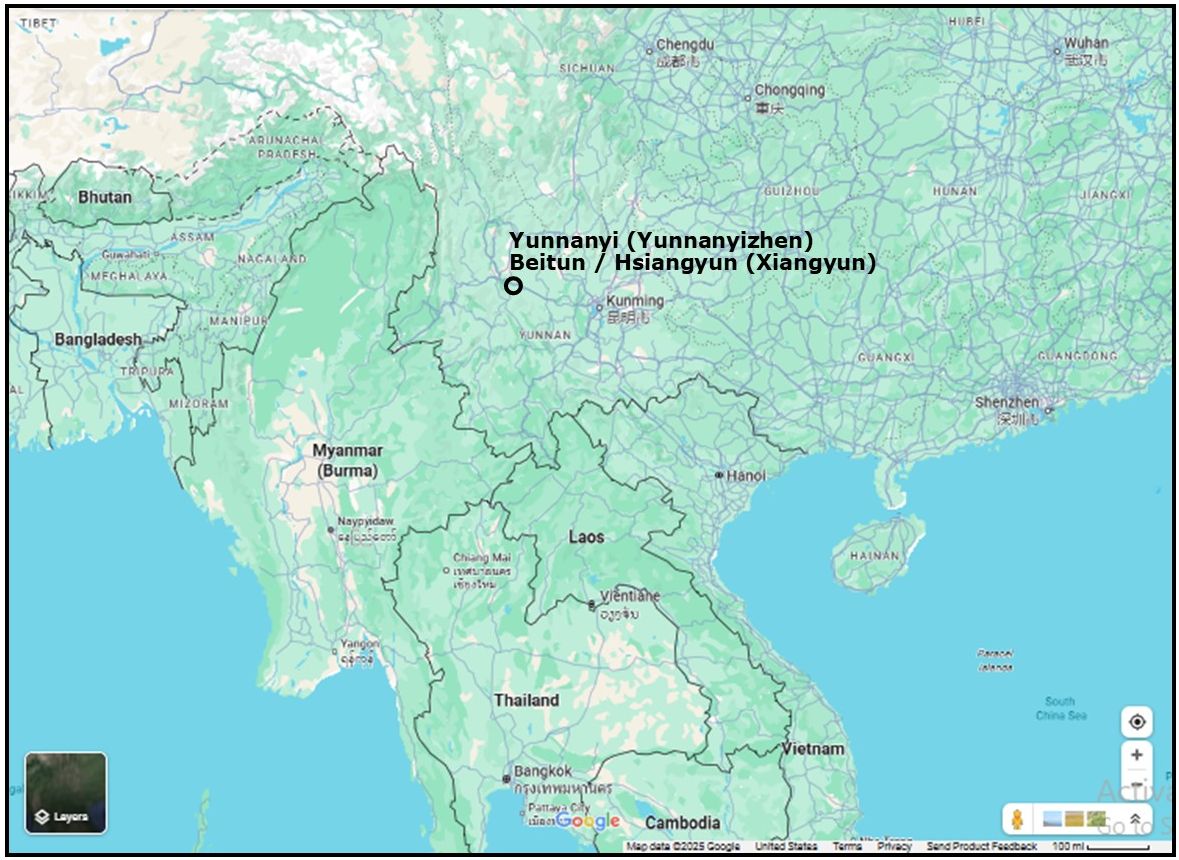
This is an exercise to differentiate two USAAF airfields in the immediate vicinity of Yunnanyi Town,1 Xiangyun County, China from which many surveillence flights and attacks targeting Thailand originated in World War II:
- Yunnanyi Field (Google Maps link). See also 云南驿机场 (1929年), Yunnanyi Airport 1929 (offsite link) (named after the nearby town, 云南驿镇, Yunnanyi (offsite link), and Burma-Road.com’s excellent photography in Yunnanyi, the old airbase along the Burma Road (offsite link).
- Beitun Field (北屯机场, no separate link found), now Xiangyun Airport (Google Maps link; see also 云南驿机场 (Yunnanyi Airport) (offsite link in Chinese).
 GENERAL LOCATION MAP
Comparing their histories can be confusing because of their proximity — runway centers just 4 km apart, the occasional sharing of some functions during the war, and simple errors in records. Compounding the confusion, as Dan Ford noted:2
U.S. airmen and the press continued to use the “Flying Tiger” name to refer to USAAF units in China to the end of the war, and the name continues to be applied to certain air force and army aviation squadrons [and associated with their locations in China]
Hence the following chronology covers historical highlights of air force activities in the Yunnanyi / Xiangyun area, though, in some cases, which field was involved, cannot be determined.
1929: Yunnanyi3 Field was constructed by Yunnan Provincial Government order dated September 1929.4 Dan Jackson describes it as:5
an all-weather gravel runway 4,864 feet long and 6,430 feet above sea level.
1938: Wikipedia records the Republic of China Air Force Academy junior technical class moving 1500 km southwest from Luoyang (Google Maps link) to Yunnanyi Field in early 1938 (to leave in 1941 and reappear at Beitun in 1943).6 Daniel Ford records Claire Chennault setting up a “primary flight school” there, also in 1938.7
1939: Construction at Beitun8 Field (云南驿机场) began in January 1939. A grass9 800 m long runway with a width of 600 m10 was completed in July of that year. While no plan for the original Beitun Field has been found, its location has been preserved by its eventually having been expanded into the current day Xiangyun Airport
1942, 10 January: American Volunteer Group (AVG) recorded this map of Xiangyun Field (“Hsiangyun”), but, the descriptions of “Location” and “Neighboring objects” better fit the original Yunnanyi Field:11
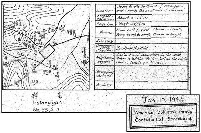
Transcript:
● Location: 20 km to the southeast of Hsiangyun and 1 km to the southeast of Yunnanyi
● Magnetic variation: about 0.43’W
● Elevation: about 2075 m
● Area: from east to west 1200m in length from south to north 800m in length
● Runway: blank
● Constant wind direction: southwest wind
● Neighboring objects: 1.5 km to the west, there is a hill. Also a hill on the north and a temple on its top.
● Surrounding obstacles: blank
● Remarks: blank
1942, April: Neither Yunnanyi Town nor an air facility appears nearby on this excerpt from Aeronautical Chart (555) Lake Erh with aeronautical data specified as April 1942:12
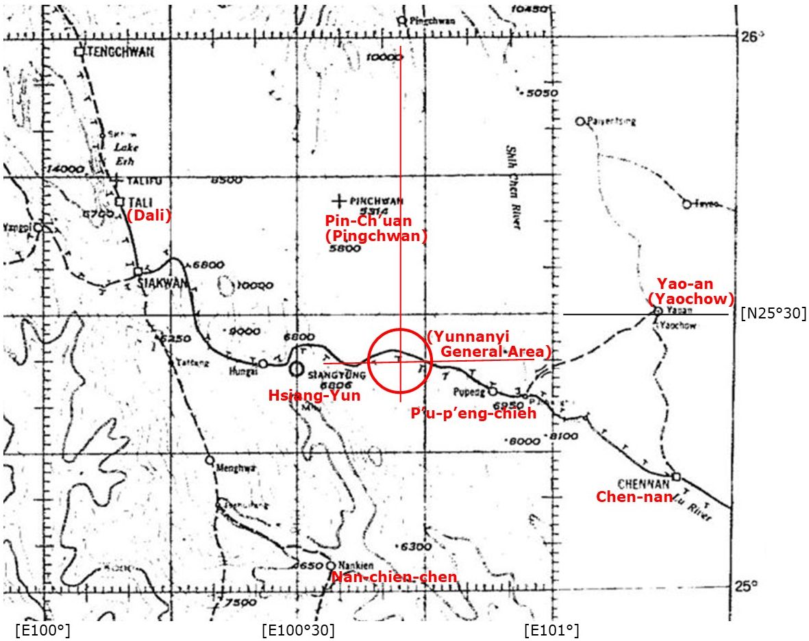
(Current locations on Google Maps that can be matched with those on this map are displayed in red)
1942: Air Force History Index13 (offsite link) lists Army Airways Communications System Squadron 158 at Yunnanyi providing support for the American Volunteer Group from 10 December 1942 to 31 March 1945 — that start date being five months after the “original” AVG had been disbanded. Presumably the communications squadron served subsequent USAAF units at the two bases.
1942: Wikipedia’s India–China Division, Air Transport Command14 (offsite link) lists Yunnanyi Station Air Transport Command (ATC 12) / Army Air Force Base Unit (AAF 1338th) functions:
[Yunnanyi]: Established in December 1942. Had supported American Volunteer Group prior to the AVG being disbanded. ATC [Air Transport Command] staging airfield on Transport Route “Love” (Barrackpore, India Eastbound to Ipin, China). Also connected into Kunming on Routes “Charlie” and “Peter” westbound to Barrackpore. Contained large storage facilities for equipment and supplies. Also supported 14th AF Fighter units. [See composite map below of ATC routes]
1943: The Index lists a history of Army Air Force Base 1338, ie, that at Yunnanyi, but only starting with date 01 January 1943.15
1943: Wikipedia’s Yunnanyi Airport16 (offsite link) further describes the airfield’s functions (but incompletely after 1943):
The Yunnanyi airfield was primarily used by transport (C-46 Commando, C-47 Skytrain) squadrons arriving from India after flying over “the Hump”. The transport aircraft unloaded supplies and equipment, primarily food and ammunition, for the Chinese forces. In addition, USAAF F-4 (P-38 Lightning) aircraft flew combat reconnaissance missions over Japanese-held areas from the airport in late 1944 and early 1945.
1943: After having left Yunnanyi Field in 1941, the Republic of China Air Force Academy junior technical class program reappeared at Beitun Field (as noted above).17
1944: AAF Aeronautical Chart dated 28 February 1944 presents Yunnanyi as a single symbol:18
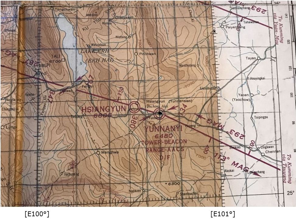
The significance of Hsiangyun (Xiangyun) on this map about 14 km WNW of Yunnanyi is unclear. Google Earth displays no feature in this area suggesting an airfield, or former one. Beitun Field, about 4 km northeast of Yunnanyi Field, would eventually evolve into present-day Xiangyun Airport).
1944, May: Air Force History Index19 (offsite link) records Col JC Kennedy as in command of Composite Wing 69 at “Beitung” Field from 01 May 1944 to 30 September 1944. Kennedy was assigned by Chennault to organize air support for Chinese troops crossing the Salween in their campaign to retake Burma, and he headquartered at Beitun on 02 May 1944. The Wing included:
● 27th Troop Carrier Squadron (TCS, primarily C-47s)20
● 19th Liaison Squadron (Stinson L-5s)21
● 25th Fighter Squadron (P-40s)22
● 22nd Bomb Squadron detachment (B-25s)23
● G Flight, 21st Photo Reconnaissance Squadron (PRS) (F-5Es)24
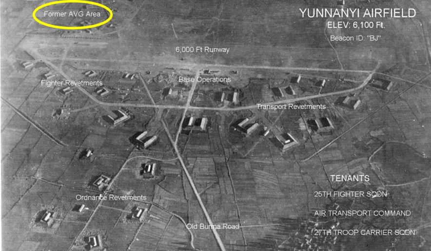
1944 (?): An oblique aerial photo below (click to enlarge) calls out a “Former AVG Area” (circled in yellow at upper left), which is consistent with the field having been functional before WWII:25
1944, June: Because the monsoon season (June-September) softened the grass runway at Beitun, two USAAF units temporarily relocated until the end of the monsoon season:26
● The 25th Fighter Squadron to Yunnanyi with its gravel runway.
● The 22nd Bomber Squadron to Yangkai since there was a hill at Yunnanyi’s SW end which a loaded B-25 couldn’t safely clear27
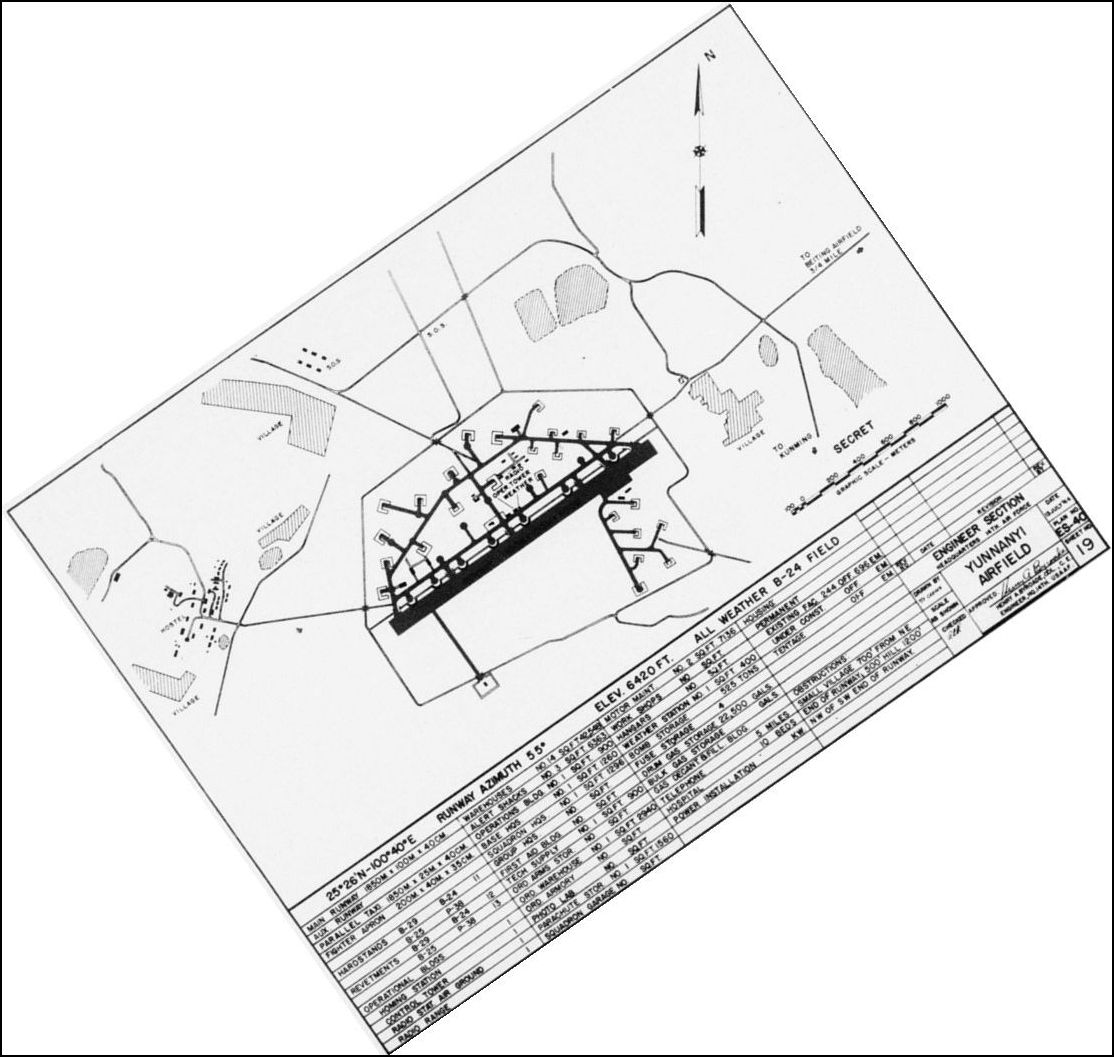
1944, July: A 14th Air Force Engineering Section plan of Yunnanyi Field, dated 13 Jul 1944, presents a well developed facility, with housing for 244 officers and 696 enlisted men. Curiously, the airfield dimensions are metric, though structures are in square feet and distances to obstructions are measured in feet. The original location as stated in the plan, N25°26 E100°40, approximates current details shown in Google Earth (N25°25.24 E100°42.2). The plan is rotated so that north is up-page:28
With the end of the monsoon season, the grass runway at Beiting Field became usable and the two units returned there:29
● 05 October 1944: A detachment of eight 22nd Bomb Squadron B-25s.
● 28 October 1944: G Flight.
1944, November: With regard to pilots based in Yunnanyi and lost over Thailand:
- 1Lt Franklin McKinney in a G Flight F-5 (a P-38 modified for aerial photography) had flown out of Beitun when he was brought down south of Lampang by a lightning strike on 05 Nov 1944.30
- 2Lt Henry Minco in a 25th Fighter Squadron, 51 Fighter Group, P-51 had flown out of the older Yunnanyi airstrip when he was downed in a dogfight east of Lampang by Royal Thai Air Force (RTAF) Pilot Officer Kamrobe Pengkham about a week later, on 11 Nov 1944. The latter loss is particularly well recorded in Thai sources because it represented a RTAF win over a better equipped, more experience enemy.31
1944, December: Another pilot based in Yunnanyi lost over/near Thailand:
- 2LT Thomas Ankrim in a 25th Fighter Squadron, 51 Fighter Group, P-51 was also flying out of the older Yunnanyi airstrip when he hit a tree on a low altitude strafe during an “offensive road sweep” in the area of Tachileik (Google Maps link; in southeast Shan State, then part of Thailand) on 07 December 1944.
1945; The two airfields are shown as a single destination, “Yunnanyi”, on this schematic of “Over the Hump” supply routes connecting Allied air fields from India to Central China (click to enlarge):32

Post-war era:33
After combat ceased in Southeast Asia:
-
- The Americans closed their facilities at Yunnanyi Field in July 1945 and China abandoned it after 1949.
- The USAAF closed its various activities at Beitun Airport in roughly the same period (eg, 22nd Bomb Squadron left on 19 January 194534 ); however, the Chinese continued using it, with the name, Xiangyun Airport. To confuse matters, Xiangyun Airport was later renamed again to become the current Yunnanyi Airport.
I checked the coordinates for the old airport, Yunnanyi, as it appears in ลำปาง ยุทธเวหา, and It clearly shows up in a low resolution Google Earth Historical Image dated 1985 (icon added):
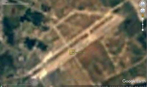
That allowed the accurate placement of the old airfield in relation to the Beitun Field, the latter now carrying the name Yunnanyi Airport:

After the founding of the People’s Republic of China, Beitun Airport became a military airport of the Chinese People’s Liberation Army.35
In 1961, the Beitun Airport Construction Committee started expansion of Beitun Airport with Project 8001. Completed in November 1964, the project extended the airport’s main runway to 2,400 meters in concrete. It then became the base of the Fourth Training Regiment of the Tenth Aviation School of the Chinese People’s Liberation Army Air Force.
In 1985, due to a “million-man military reduction”,36 the troops and aircraft were transferred and the airport was closed. Satellite images from Google Maps in 2018 showed that Beitun Airport had been reopened, with fighter jets parked on the apron.
2014: I was curious about how many revetments were still visible. The 14th Air Force drawing shows perhaps 26 (that number depending on how one interprets the symbols on the plan). Bob Bergin visited Kunmng and Yunnanyi in 2014, and mentions in Protecting the Tiger Heritage – Kunming (offsite link):
Yunnanyi became the main American base in western Yunnan, but near the end of the war, air operations were shifted to a nearby airfield that had been prepared for the B-29s that were intended to bomb Japan. After the war the original airfield was abandoned and has largely returned to rice fields. The only sign of its WWII role are aircraft revetments on which eucalyptus trees grow. The second airfield became a base for the Peoples’ Liberation Army Air Force.
Of course, at ground level, his view of the landscape would have missed details visible from a satellite view. The image most clearly showing revetments in the area is dated 2010. Added to the image are the outline of the old airfield plus circles around visible revetments. Eighteen revetments are still visible in this view:
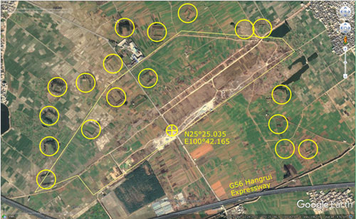
With regard to the former Beitun Field, evidence of revetments are not visible in that same 2010 aerial view, probably because the field was not abandoned and subsequent development obscured old features.
Now: Wikipedia uses the name, “Yunnanyi Airport” (offsite link) for its English language article describing the present-day airport, but with coordinates pointing incorrectly to the older Yunnanyi Field, not the later Beitun Field.
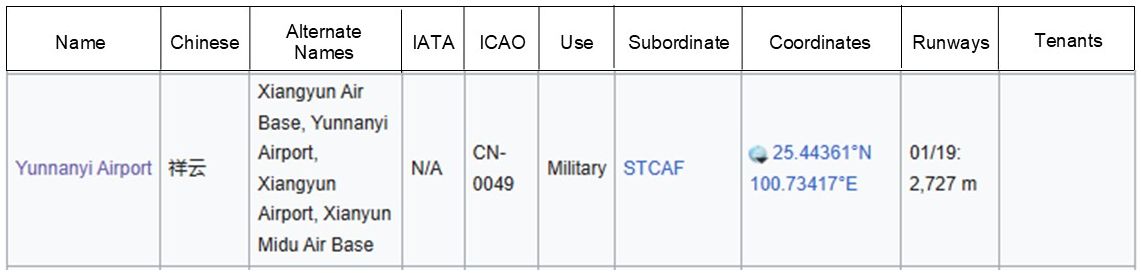
However, by whatever name, Wikipedia, in its separate article, List of People’s Liberation Army Air Force airbases (offsite link), identifies the current air facility as a “military airport” and with correct coordinates:
| Drafted, not linked to index | ||
| Linked to index | ||
| Converted to WordPress by Ally Taylor | ||
| Updated, author errors & typos corrected | ||
Last Updated on 16 October 2025
- Administrative hierarchy:
PRC (Beijing)
Yunnan Province (Kunming)
Dali Bai Autonomous Prefecture (Dali Town)
Xiangyun County (Xiangcheng Town)
Yunnanyi Town[↩] - credited by Wikipedia in Flying Tigers: Transition (offsite link) to Dan Ford, Flying Tigers (Washington: Smithsonian, 2007), Ch 17[↩]
- 云南 can be translated as “cloud south” per Google[↩]
- Wikipedia, 云南驿机场 (1929年) (offsite link); my ref: \03000 Sources\03401 Chinese\Wikipedia-Yunnanyi AP.docx[↩]
- Jackson, Famine, Sword, and Fire (Atglen PA: Schiffer, 2015) p132[↩]
- ibid[↩]
- Daniel Ford, Flying Tigers.(Washington: Smithsonian Press, 2007), p 21.[↩]
- 云南 can be translated as “north village” per Google[↩]
- Jackson, ibid, p 132[↩]
- Wikipedia 云南驿机场 (offsite link); perhaps what is described was an older-fashioned oval field per Wikipedia: Aerodromes (offsite link) [↩]
- Extract from USAF Archive microfilm roll 25866 pp 564-676 showing a group of airfields in China. My ref: \03400 USFE Cmd Documentation\USAF Archives\_TOPICS\_Charts AVG USAF 25866\AF 5.0 pp 648-654\AF50\AF50-pp-648-654.jpg[↩]
- extract from Aero Chart 555 lake Erh 1941 1:1,000,000. Source: USHRA Reel 25882 p993, 994 “Aeronautical Chart (555) Lake Erh”; my ref: \03700 Yunnanyi, China\Aero Chart 555 Lake Erh ext.jpg[↩]
- pdf 197922[↩]
- ATC 12 / AAF Base Unit 1338th[↩]
- Air Force History Index, pdf 269303 (offsite link) [↩]
- an early reference in the article to “Siangyun Airfield” would probably have been intended for Hsiangyun, which appears in the map below, and I believe to have been in error[↩]
- Wikipedia, 云南驿机场 (offsite link) [↩]
- AAF Aeronautical Chart (555) Lake Erh dated 28 Feb 1944; provided by: Sara Normand Cavalieri email 17:27 05 Nov 2024. My ref: \02370 Yunnanyi, China\Two airfields\1944 Feb.pub and bPROJECT\_MAPS\SE ASIA MAPS\Maps not Thailand\China Maps (TXU)\Kunming\Map 5a-red.jpg[↩]
- pdfs 106463, 106464[↩]
- arrived 21 May, Jackson, ibid, pp 101, 117[↩]
- arrived 29 April, Jackson, ibid, pp 101, 120[↩]
- Jackson, p 101; but the squadron relocated to Yangkai during monsoon weather which softened up Beitun’s grass runway, Jackson, ibid, pp 132, 134[↩]
- On 29 April 1944, 22nd Bomber Squadron, based at Yankai, China with B-25s, sent a detachment to operate at Yunnanyi, USAAF Chronology 1941 – 1942); however, a Dan Jackson interviewee said that the detachment actually arrived on 11 September 1944 (Jackson: Hayward, David K. “Bombing Bulldogs in the Salween Campaign” (offsite link) October 2012)
● 449th Fighter Squadron (P-38s)((detached from Chenggong, arrived 25 July, Jackson, The Forgotten Squadron (Atglen PA: Schiffer, 2010), pp 75, 82[↩] - arrived 09 September, Jackson, Famine, Sword, and Fire, ibid, pp182, ff[↩]
- Source: ลำปาง ยุทธเวหา (offsite link) credits Yunnan China Airfields (offsite link) by Robert Anderson, who in turn credits Mr Ge Shuya of Kunming. Shuya was a historian expert on Yunnan County in World War II; amongst other achievements, he rediscovered the Burma Road’s switchback road “24-Zig”(N25°49.3 E105°12.1) (Google Maps link) in 1995 (China Daily (offsite link). That section of road, though a signature for the Burma Road, is not actually a part of it, since it is beyond Kunming, the eastern terminus of the road (See also Burma-Road.com’s discussion and excellent photography in The Burma Road that isn’t Burma Road (offsite link) ) Located near Qinglong in Guizhow Province on the way to Chongging: the “Zig” is about 600 km northeast of Yunnanyi by road. My ref: \02370 Yunnanyi, China\Yunnanyi 1944a.jpg[↩]
- Jackson, ibid, pp 132, 134[↩]
- Dan Jackson’s interviewee makes no mention of the earlier arrival and departure of this unit in June.[↩]
- Found in USAF Archives, Maxwell Air Force Base, and provided by Daniel Jackson email of 10:54 05 Nov 2018[↩]
- Jackson, ibid, p 185[↩]
- Jackson, Fallen Tigers (Lexington: Univ of Kentucky, 2021), pp 176-177[↩]
- Ibid, pp 178-181[↩]
- Assam-Bengal-China Air Routes – USAAF – Air Transport Command – CBI Theater of World War II – 10 July 1945 (offsite link) [↩]
- 云南驿机场 (offsite link), unless otherwise noted, translated by Google and condensed by author[↩]
- Daniel Jackson’s Flying Tiger Page: Hayward, David K. — 22nd Bomb Squadron[↩]
- 云南驿机场 (offsite link), continuing, unless otherwise noted, translated by Google and condensed by author[↩]
- Wikipedia, People’s Liberation Army (offsite link):
. . . under the leadership of the Central Committee of the Chinese Communist Party (offsite link) and the CMC, the PLA changed from being constantly prepared to “hit early, strike hard, and to fight a nuclear war” to developing the military in an era of peace. The PLA reoriented itself to modernization, improving its fighting ability, and becoming a world-class force. Deng Xiaoping stressed that the PLA needed to focus more on quality rather than on quantity.
The decision of the Chinese government in 1985 to reduce the size of the military by one million was completed by 1987. Staffing in military leadership was cut by about 50 percent.[↩]