1930-1941: During this period, Tanaka became more involved with the IJA as preparations were made in the eventuality of a Japanese presence in Thailand and an invasion of British Burma.
1930: In Bangkok, Shu Hatano had worked for 16 years in the photo shop of his brother, Shozo Hatano. In 1930, Shu was approached by an IJA Colonel Kanji Tsuneoka who pressed Shu to accompany him to Chiang Mai where the colonel was to meet Tanaka; the colonel identified himself as a military attaché at the embassy in Bangkok. Shu was acquainted with Tanaka from his trips to Bangkok to purchase photographic supplies. Obviously there would have been some discussion between the colonel and Shu’s brother, and possibly Tanaka, regarding the use of Shu.1 There is some evidence that the colonel had at one time looked upon Shu Hatano as a potential assistant.2
In August, the colonel and Shu journeyed to Chiang Mai. There, Tanaka put his shop in the hands of the just arrived Shu and disappeared with the colonel for “many days”. It is important to note that Tanaka had been based in Chiang Mai since 1911, so he had almost 20 years there, doing what is only recorded in very occasional photographs coming to light (photographing the Bombay Burma railway/logging operations in southern Lampang province (sometime within the period 1926-1929)3 and in Muang Hang, Burma4 ). In the late 1980s, Shu recalled that, on his return, Tanaka had spoken of traveling around Burma, Laos, China, Vietnam, and Cambodia with the colonel, collecting information.2 If one journey had covered all objectives, a very broad brush itinerary for a hypothetical journey might have been:5
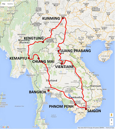
As shown above, from Chiang Mai and moving clockwise to loop and return, they would have traveled about 4,500 km.6 At that time, land travel was often over trails such as this:7
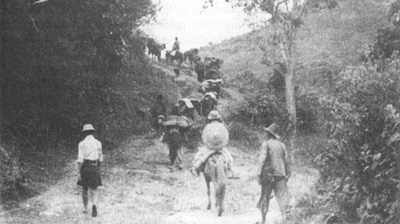
That distance, over roads of this type, if only on foot, could represent about 150 days, which would certainly constitute Shu’s description of “many days”.8 However, bus service of varying quality was probably available over most of their route and using it would have eased their effort. With alterations to the route above, they might well have taken the Old Elephant Trail to Mae Hong Son instead of following close to the border with Burma; they might have floated down the Mekong from Kunming to Saigon; or ridden the Yunnan–Haiphong railway (offsite link), completed in 1910, from Kunming to Hanoi and then headed south to Saigon on Vietnam Railway‘s North South Railway (both offsite links), which was complete except for the 524 km Tourane–Nha Trang section, before turning west for Bangkok: while increasing their journey’s distance, those alternatives would have shortened the absence that Shu recalled.
The motivation for this effort would have included Japan’s uncertainty about a growing conflict in China between the forces of Mao Tse Tung and Chiang Kai-shek, and about the intentions of Britain and France whose possessions bordered Siam. An additional motivation would become clear later: evaluating a potential road route from Chiang Mai through Mae Hong Son and connecting to, probably, existing Burmese roads leading to Toungoo. With the return of the pair, Shu got the impression that thereafter Tanaka always had a reliable supply of photographic materials and equipment9 (however, Shu made this observation with no idea of what might have transpired between Tanaka and the IJA, prior to his (Shu’s) arrival in Chiang Mai in 1930. There is an impression that all Japanese photographers outside Japan were adequately supplied with equipment and materials by the Japanese government in the leadup to war in return for their cooperation in photographing items of interest;10 though perhaps not, for Shu had worked at his brother’s shop in Bangkok since 1914 and should have been aware of any such relationship. Conversely, perhaps Shu chose not to reveal such to Matsumoto.
1931: In April, Colonel Tsuneoka was promoted to the army general staff and left Siam.11 By 1941, the military attaché was Tamura Hiroshi.12
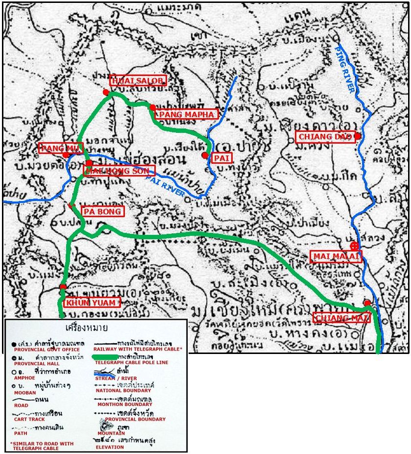
1933: In accord with an agreement with either Colonel Tsuneoka or a successor,13 Tanaka began a “terrain survey” along the Burmese border. The assignment apparently included staking out a route between Chiang Mai and Khun Yuam in Mae Hong Son Province. Khun Yuam was seen as providing the easiest access to already established roads in Burma leading to Toungoo, a transportation hub with river, rail, road, and air connections.
The obvious choice for this route was the 176 km long Old Elephant Trail, shown in tan below: time-tested for decades if not centuries, it connected Chiang Mai with Mae Hong Son and its elephant market.14
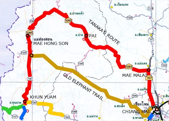
However, for reasons unclear, Tanaka chose a much longer route, shown above in red, arching far north past Pai, on mostly local trails, and totaling around 300 km.15 Tanaka may have been influenced by views of others regarding elephants in general such as this:
. . . Elephants were probably used for official equipment and supplies of rice. They are relatively slow compared with ponies or horses, the other principal means of transport, and were dispensed with altogether by McLeod between Chiang Tung and Chiang Rung, when he travelled much faster.16
The bridge which leads over the Méping seems of considerable age: (the river here is 380 feet wide, as I ascertained by measurement), and although men, horses and cattle pass over it, the elephants have to ford the river. These animals are too heavy for such a frail structure . . .17
Traveling with elephants is more cumbersome and slower. You also have to stick to the major military roads with them, because the usual jungle paths don’t offer enough space. . . . On the other hand it would be possible to reach the carrier speed with packing ponies. . . . On the other hand, it is used with success to carry mail. The caravans coming from Yunnan always use horses. Otherwise the great distance could hardly be covered.18
Further it is not recorded if Tanaka showed the colonel both the Old Elephant Trail and his (Tanaka’s) own devised route; so ultimate responsibility for Tanaka’s eventual proceeding with staking out his route cannot be ascertained. In any case, it consisted of:
- From Chiang Mai to Mae Malai, an existing road leading to Chiang Dao and points north, the future Thai Route 107.
- Between Mae Ma Lai and Pai, an existing, dry weather only, trail.19
- Between Pai and Mae Hong Son, the maintenance trail for a telegraph line coming from Mae Hong Son to service Pai; here Tanaka was relying on the logic of European engineers who had scouted the area in the 1880s before installing the telegraph line. The route was clearly the basis for present-day Thai Highway 1095.
A 1915 vintage map showed the telegraph system in northwest Thailand. (‘Map 13, Ministry of Education, Phumisat Prathet Sayam, pp 156-157′):20
From just south of Mae Hong Son town, both choices followed the telegraph line south to Mae Sariang as far as Khun Yuam, about 50 km, and a further 70+ km to the border.
It should be noted that IJA planning in 1943 for access from Chiang Mai to Burma describes only the “Chiang Mai-Toungoo” Road. Never mentioned is Mae Hong Son. Nonetheless, it seems that the IJA 15th Division responsibilities were limited to constructing only the Thai portion of the road. And presumably Tanaka’s were similarly limited. Following Tanaka’s route, the distance between Chiang Mai and Khun Yuam is about 350 km. At a walking speed of 3 km per hour,21 10 hours per day, ie, 30 km per day, Tanaka would have taken about 12 days just to travel to the far end of his project, plus an equal interval to get back, plus time expended in survey work. As a one-man assignment, it was necessarily long term.
1935: Tanaka was in Chiang Mai to record the dedication of the road to Wat Doi Suthep, built by the monk, Kruba Sriwichai:22
1939: Shu Hatano married Tanaka’s daughter, Kumpoon.23
Between 1930 and 1939, Tanaka performed “many surveys” in Laos.24 Matsumoto recalled a photo that Hatano had shown him, and which the author duplicated in his book, of Tanaka dressed in Laotian clothing with a Japanese medal on his chest. The photo was dated “immediately following WWII”, in Chiang Mai.25
1940-1941: From October 1940 to May 1941, Siam fought French forces in French Indochina in an attempt to regain control of territory lost during King Chulalongkorn’s reign. The war was characterized as a defeat for Siam on the sea, but a victory in the air. Japan chaired peace negotiations, and ensured that France returned all the disputed territory to Siam.26
For an indeterminate number of years prior to the Franco-Thai War (1940-1941), Hatano recalled that Tanaka had traveled at least once a year to Saigon at the request of an embassy military attaché. Tanaka’s photo subjects had seemed to center on French warships.27 And it is reasonable to assume that Tanaka was journeying to Saigon per request of that military attaché before Shu arrived to witness it. This is curious for it suggests that Japan did not have agents in Saigon to perform this task. Further, and perplexing, Tanaka was known for using only plate cameras — no German Minox Riga (spy) miniature cameras for him; so he must have been very visible to French authorities when he was photographing French warships, with camera on tripod, and him and camera under black hood while focusing.28 And he wouldn’t have carried the exposed plates all the way back to Chiang Mai for processing, so there was the problem of securing an absolutely dark room for the initially processing of the plates and also the subsequent reloading of the plate holders with fresh plates for the next “shoot”. In all his travels, he must have been accompanied by a large quantity of baggage to transport the necessary paraphernalia. Or perhaps in this instance he was able to make arrangements for processing with an anti-French Vietnamese photo shopkeeper.
1941: “In mid-March, Tokyo ordered the opening of another [consulate, this] in . . . Chiang Mai . . . . the new offices were designed primarily as intelligence-gathering posts.”29
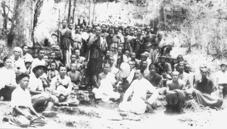
In February, representatives of the Minami Kikan [Minami Organ (organ as in organization)], an independent arm of the IJA, had been charged with supporting and liaising with the Burma Independent Army (BIA). Among their objectives was setting up liaison points on the Thai-Burma border.30 Four such points were subsequently set up, with the most northerly of them being Chiang Mai.31 There it functioned as a commercial and development organization which allowed it the freedom to investigate remote areas.32 Charles Keyes was told by old Mae Sariang inhabitants in 1967 that, before the war, some Japanese had come there nominally as gardeners and traders to map the area in preparation for military action. Those Japanese did not apparently remain there during the war.33 Tanaka would not have been designated the Minami Kikan representative in Chiang Mai for its members had been carefully selected and specially trained in working with the BIA in Burma in combat conditions. However, tasks set out for the Minami Kikan effort included “reconnaissance . . . to be made of the topography and roads from the Thai border into Burma, and a military geography compiled.”34 For this last, it would appear that Tanaka must have been a major resource for the Minami Kikan: thus he would have been quite busy during most of 1941.
July 1941:
In various despatches to the British Foreign Office, British Minister to Siam, Josiah Crosby, reported Japanese infiltration. An obvious one was in July when a Japanese Camera Department came and sent out teams of photographers to record the “cultural entente” between Thailand and Japan. A secret source imparted that a complete list of films already produced included highways, anti-aircraft facilities in Thailand, aeroplanes, the salt industry, British firms in Thailand and various government workshops. Crosby commented that Thai Government probably knew but dared not oppose it. Then came an increase in Japanese tourists to Thailand, especially in the south, in October 1941.35
01 December 1941(?): A Mitsui employee in Bangkok recalled that Japanese residents were called together “several days” before the “invasion” to be told that the IJA would invade on 08 Dec 1941. Whether this information found its way to Chiang Mai is unknown.36
08 December: IJA troops entered Thailand.
15 December: IJA personnel first appeared in Chiang Mai.37 Boonserm recalls that Tanaka was at the railway station to greet the first IJA troops to arrive. It is apocryphal that Tanaka was wearing a uniform when he met the first troops. However, Boonserm smiled at the story and said such was not the case. But Boonserm, aged 13 at the time, did not claim to have been present at the rail station when the IJA troops arrived. Conversely, his cousin, Wichit Jayavann, 17, claimed to have been present and strongly asserted that Tanaka did welcome the incoming IJA troops in his own uniform, with rank of major.38 In what capacity Tanaka welcomed the incoming troops, whether in uniform or civilian garb, is unclear.39 While Tanaka would have been the best-recognized of Japanese welcoming the IJA troops at the Chiang Mai railway station, presumably the most important would have been the recently arrived consul, Chichiro Harada, with his assistant, Nishino Junjiro. There was also an unknown number of Minami Kikan,40 though they might not have been in Chiang Mai at the time; and there was another photographer, Yagi.41 But not recorded is the presence of any but Tanaka to greet the IJA troops newly arriving at Chiang Mai Railway Station. If Tanaka was authorized to wear a military uniform, at his age of 66, Tanaka might well have been the most senior active member of the Japanese military.42
[Continued: Tanaka from 1942 to 1961]
Last Updated on 23 November 2025
- Matsumoto, p 195.[↩]
- Matsumoto, pp 74, 197.[↩][↩]
- BR Whyte, The Railway Atlas of Thailand, Laos and Cambodia (Bangkok: White Lotus, 2010), pp 105-106[↩]
- date missing[↩]
- Map image: Nations Online: Map of Southeast Asia (offsite link, but map has changed); annotation by author using Microsoft Publisher. Distance calculated from Google Earth Ruler utility and Whyte, BR, The Railway Atlas of Thailand, Laos and Cambodia (Bangkok: White Lotus Press, 2010), pp 29, 39.[↩]
- rome2rio.com used for estimating distances, assuming transport by road.[↩]
- Payap Collection: extract from Image no. 23, undated, by unknown. Photo also appears in Sarassawadee Ongsakul, History of Lanna (translated by C Tanratanakul) (Bangkok: Silkworm Books, 2001), p 233 as No. 104 with caption “The road used by caravans in transporting goods”, dated 1942, and attributed to the National Archives of Thailand.[↩]
- That assumes a walking speed of 3 kph and a ten hours of walking per day (TrailTrove.com/Hiking Speed (offsite link no longer available) ).[↩]
- Matsumoto pp 196, 197.[↩]
- Boggett email 16:57 24 Sep 2011[↩]
- Matsumoto p 198.[↩]
- The Pacific War Online Encyclopedia (offsite link) [↩]
- Matsumoto, p 198.[↩]
- Map annotated by author using Microsoft Publisher; my ref: \02300 Route choice\02310 Northern route\02310 00 Maps\CNX markup map GEN1 NORTHERN RTE.pub, sht 1[↩]
- The location of a telegraph station in Pai evidenced King Rama V’s interest in tying the kingdom closer together and it has been suggested that Tanaka’s choice of route might have reflected that interest; however, the IJA tasked Tanaka with planning an expeditious connection to Burma through Mae Hong Son, not improving security along Thailand’s northern border.[↩]
- Volker Grabowsky and Andrew Turton, The Gold and Silver Road of Trade and Friendship (Chiang Mai: Silkworm, 2003), p 113; my ref: \02200 Chiang Mai city\Tanaka\_Add\horses vs elephants.txt[↩]
- Schomburgk, Sir Robert, ‘A Visit to Xiengmai, the principal City of the Laos or Shan States’, Journal of the Asiatic Society of Bengal (Calcutta), 32, 4 (1863). As presented in CPAMedia’s ‘Schomburgk’s Account of ‘Xiengmai’ in 1859-60 with text by Andrew Forbes, at http://www.cpamedia.com/research/schomburgk_city/; my ref: Schomburgk, Sir Robert, ‘A Visit to Xiengmai, the principal City of the Laos or Shan States’, Journal of the Asiatic Society of Bengal (Calcutta), 32, 4 (1863). As presented in CPAMedia’s ‘Schomburgk’s Account of ‘Xiengmai’ in 1859-60 with text by Andrew Forbes, at http://www.cpamedia.com/research/schomburgk_city/Schomburgk, Sir Robert, ‘A Visit to Xiengmai, the principal City of the Laos or Shan States’, Journal of the Asiatic Society of Bengal (Calcutta), 32, 4 (1863). As presented in CPAMedia’s ‘Schomburgk’s Account of ‘Xiengmai’ in 1859-60 with text by Andrew Forbes, at http://www.cpamedia.com/research/schomburgk_city/; my ref: \02200 Chiang Mai city\Bridges, Dams, Tribs for Ping\Ping Bridges.docx[↩]
- Chronicle of Thailand 1913-04 – 1914-03 (offsite link); my ref: \02200 Chiang Mai city\Tanaka\_Route choices\Old transport.docx[↩]
- Interview with Bpagaun Chaisane, retired school principal in Tambon Sop Poeng, Amphur Mae Taeng, 19 Sep 2021; my ref: \02310 Northern route\02313 1095 012 Sop Poeng\02313 1095 012 Sop Poeng School.docx[↩]
- ‘Map 13, Ministry of Education, Phumisat Prathet Sayam, pp 156-157′, from Chiang Mai University Library. Annotations by author using Microsoft Publisher, with telegraph lines in green:
(My refs: \02200 Chiang Mai city\Tanaka\_Route choices\1915 Monthon Phayap\Monthon NW-1.jpg (CMU Library); \02300 Route choice\02310 Northern route\_Actual route followed\Ongsakul maps-Thai ed\Phayap.pub, sht 1,2,3 (Ongsakul, History of Lan Na (Bangkok: Silkworm, 2005), p 184)
Note that the 1915 date is not displayed on the map, but is an attribution of the source, Phumisat Prathet Sayam; and is not disputed by Ongsakul; however, it is contradicted by showing the railway which did not reach Chiang Mai from Lampang until 1922; however, whether 1915 or 1922 or sometime later, the map shows no connection south/southeast from Pai to Chiang Mai.[↩]
- Or perhaps slower: this is the low end of an average range, to allow for steep slopes, poor trail conditions, porters, the occasional photo, etc. (TrailTrove: Hiking Speed: link no longer active).[↩]
- Payap University Collection, no. 107. Dated as 30 April 1935 per Wat Doi Suthep Official Website (accessed 2013, but no longer exists in Nov 2015).[↩]
- Matsumoto, p 229.[↩]
- Matsumoto, p 85. Note that Matsumoto (and / or Hatano) is ambiguous in describing the nationality of the costume as Vietnamese or Laotian (pp 30, 33, 85, 197).[↩]
- Matsumoto, p 30.[↩]
- Wikipedia: Franco-Thai War (offsite link).[↩]
- Matsumoto, p 83.[↩]
- see Fit to Print: Glass plate photography (offsite link) [↩]
- Reynolds, EB, Thailand and Japan’s Southern Advance (New York: St Martin’s Press, 1994), p 66. The other consulate opened was in Songkhla.[↩]
- Tatsuro, Izumiya, The Minami Organ (Tokyo: Tokyo Shoten, 1967), translated by U Tun Aung Chain, 1981, pp 25-27.[↩]
- Ibid, p 37. The other three were Rahaeng (Tak) leading to Mae Sot, Kanchanaburi which eventually led to the Death Railway, and Ranong on the Andaman Sea, the end point for the Kra Railway.[↩]
- Lebra, JC, Japanese-Trained Armies in Southeast Asia (Singapore: Institute of Southeast Asian Studies, 2010), pp 59-60.[↩]
- Charles F. Keyes Field Notebooks, Thailand 14 July – 25 Aug 1967 (formerly on-line at ResearchWorks at the University of Washington); my ref: \02300 Route choice\02330 Southern Route\02330 108b 104 Mae Sariang\Keyes\1967_07_July_August_Keyes_Fieldnotes_Mahasarakham_Mae_Sariang.pdf[↩]
- Ibid, p 27.[↩]
- Charivat Santaputra [จริย์วัฒน์ สันตะบุตร]: Thai foreign policy 1932-1946 (Bangkok: Thai Khadi Research Institute, Thammasat University, 1985), p 262; per Chroniks Thailand (offsite link, in German, search for Japanische “Touristen”).[↩]
- Roberts, JG, Mitsui: Three Centuries of Japanese Business (Tokyo: Weatherhill, 1973), Ch 24 (no longer available on-line). Also, Military Attaché Tamura Hiroshi in Bangkok learned of the 08 Dec Japanese “strike” on 02 December (Reynolds, p 78). “All the main Japanese . . . commanders received a message on December 2 which simply said “Climb Mount Niitaka 1208.” (Stowe, p 208). Masao Seto commented (translated from Thai), “. . . on 04 December 1941, a Thai newspaper reported that Japanese troops would enter Thailand between 08 and 15 December, most likely 10 December which was Thailand’s Constitution Day” (ชีวิตของมาซาโอะ เชโตะ ผู้ถูกพ่อและญี่ปุ่นทอตทิ้ง เล่ม 1 แปลจาก (ชีวิตของมาซาโอะ เชโตะ) แปลโดย : บ้ณทิต ประติษฐานวงษ์ [Autobiography: A man Neglected by Father and Japan (Bangkok: Marugoto (Thailand), 2003), pp 60-66.[↩]
- Chainilphan, MR, “Chiang Mai Skies during WWII”, Thai News (Thai language newspaper), 18 Dec 2009.[↩]
- Discussion with Wichit Jaravann 18 Aug 2017.[↩]
- On the other hand, David Boggett (in numerous discussions) noted that, in the months prior to the war, IJA uniforms had been handed out to many Japanese civilians, including photographers, hair dressers, doctors, and others, with no clarification as to purpose (eg, Boggett email 16:57 24 Sep 2011).[↩]
- Tatsuro, ibid, pp 25-27[↩]
- Boonserm, p 49[↩]
- For example, Admiral Isoroku Yamamoto, one of oldest and most notable of Japan’s officers, still active, was aged 57.[↩]