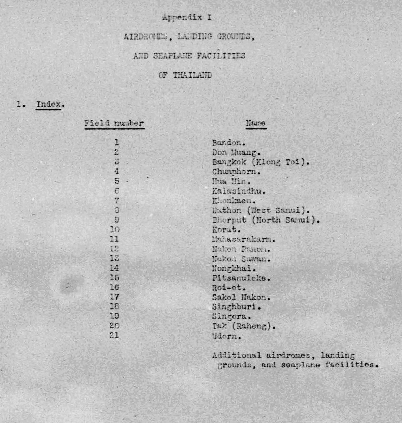
Existing records of the development of air facilities in the Uttaradit area provide a somewhat confusing history. The following reviews the subject chronologically. Significant other events are included in brackets.
.[11 Nov 1908: the Phitsanulok–Ban Dara Junction (Google Maps links) section of the Northern Railway opened, connecting Bangkok with Ban Dara Junction.1]
.[15 Aug 1909: the Ban Dara Junction–Pang Ton Phueng2 (Google Maps links) section opened which included Uttaradit Railway Station.3]
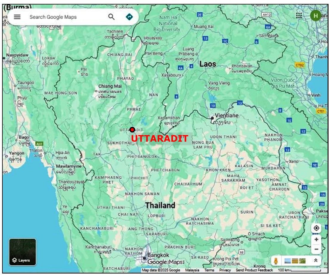
12-15 Feb 1924: Uttaradit first appears in RTAF records with flight demonstrations scheduled there during a grand tour of airfields in northern Thailand by three RTAF Breguet 14 bombers in early 1924. It is unclear as to which of the four facilities in Uttaradit later identified during World War II they might have used.4
15 Mar 1941: A Survey of Thailand (Siam) was published by the US War Department,5 and included a listing of air facilities.6 Note that the report did not include Uttaradit as one of twenty-one significant air facilities:7
And note that the list also did not include Lampang or Chiang Mai. Uttaradit, as well as the other two northern Thai airfields, was included in a listing of “Additional airdromes, landing grounds, and seaplane facilities (correct up to April, 1940)” as a “civil landing ground” — as was Chiang Mai. Lampang, though not included in the index above, was nonetheless classified as a “military landing ground”:8
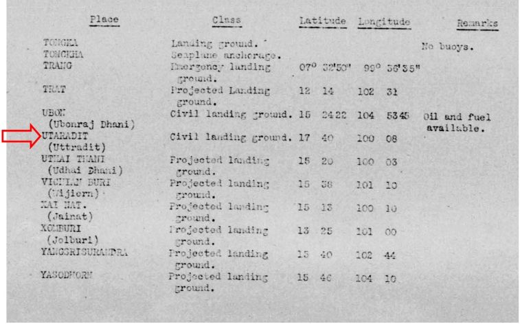
Transcript, key items:
Place: UTARADIT (Uttradit)
Class: Civil landing ground
Latitude: 17 40
Longitude 100 08
And both Lampang and Chiang Mai were also included in this listing. It is also notable that, amongst the 21 air facilities judged significant (in the index), only one was classified as “military”, ie, Don Muang; while ten more classified as “military” were included in the second, “Additional”, list.
07 March 1942: Foggy weather hindered an RTAF Squadron flying out of Don Muang in search of enemy aircraft which had been reported over Fang District. During their return flight, the aircraft became separated and Lt Sawai Kotchawat took his Ki-27 to Uttaradit while most of the others landed at Nakhon Sawan.9
23 January 1943
Field Marshal Phibun was in Uttaradit inspecting government works when he learned of heavy casualties being suffered by the Royal Thai Army (RTA) in trying to advance to Mong Se and Mong Hai passes on the border between Yunnan in China and Kengtung in Saharat Thai Doem (Shan States). He ordered Air Vice Marshal (AVM) Ritthakanee to meet him at Uttaradit Tha It Airfield 2. There the field marshal reviewed how the enemy held the high ground at the passes and ordered Ritthakanee to provide immediate air support to the RTA.10
03 March 1943: Five Vought Corsair fighters ferrying from Koke Kathiem Airfield to Chiang Rai Airfield, stopped on the way at Uttaradit Airfield.11
19 October 1943: The Royal Thai Air Force and Japanese Army agreed to immediately start building / improving certain existing Thai air bases including Uttaradit.12
1944: Allied aircraft took numerous aerial photos of the Uttaradit area during the year.13
January 1944: Airfield Schedule for Uttaradit Landing Ground shows two airstrips listed for the first time:14
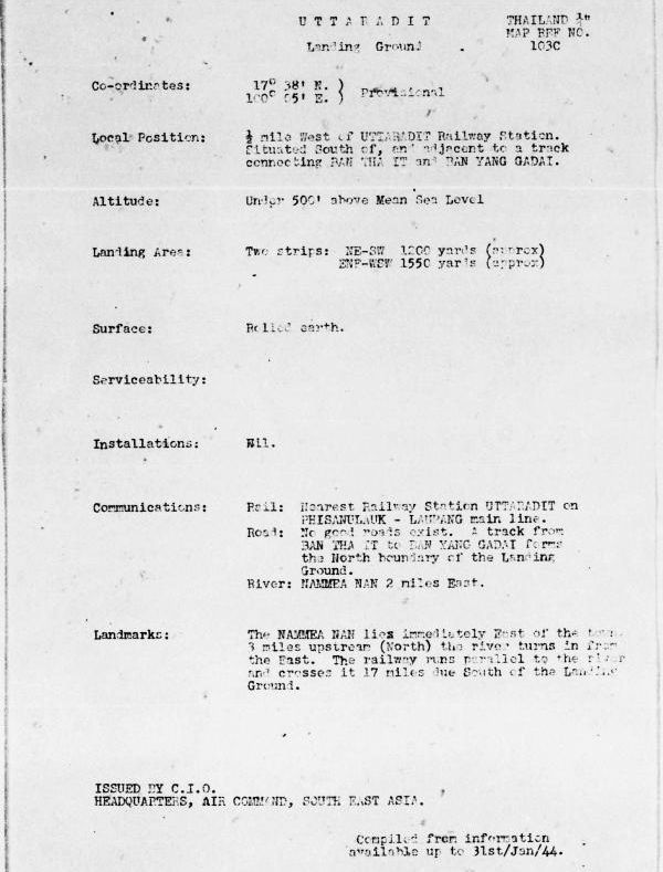
Transcript:
Thailand 1/4″ Map Ref No. 103C |
|
| 17°38′ N 100°05′ E |
|
| 1/2 mile west of UTTARADIT Railway Station Situated south of, and adjacent to a track connecting BAN THA IT and BAN YANG GADAI |
|
| Altitude: | Under 500′ above Mean Sea Level |
| Landing Area: | Two strips: NE-SW 1200 yards (approx) ENE-WSW 1550 yards (approx) |
| Surface: | Rolled earth |
| Serviceability: | |
| Installations: | Nil |
| Communications | Rail: Nearest Railway Station UTTARADIT on PHISANULAUK-LAMPANG main line. Road: No good roads exist. A track from BAN THA IT to BAN YANG GADAI forms the north boundary of the Landing Ground. River: NAMMEA NAN 2 miles east. |
| Landmarks: | The NAMMEA NAN lies immediately east of the town. 3 miles upstream (north) the river turns in from the east. The railway runs parallel to the river and crosses it 17 miles due south of the Landing Ground |
| Issued by CIO,15 Headquarters, Air Command, South East Asia Compiled from information available up to 31st/Jan/44 |
|
A separate graphic, or “airfield miniature”, shows the positioning of the two airstrips:16
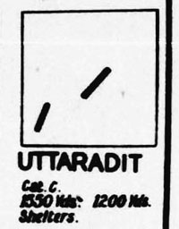
Transcript:
UTTARADIT
Cat C (liable to become unserviceable after rains)
Runway lengths: 1550 Yds. 1200 Yds.
Shelters: [type, quantities not stated]
A 24 Jan 1944 aerial photo of the Uttaradit area shows the two runways. Photo has been rotated so that north is page-up according to north arrow next to the title block on the image:17
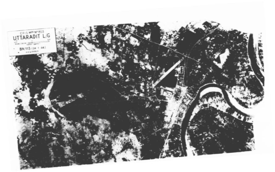
Better copy provided by Sakpinit Promthep, email 12:14 04 May 2022:
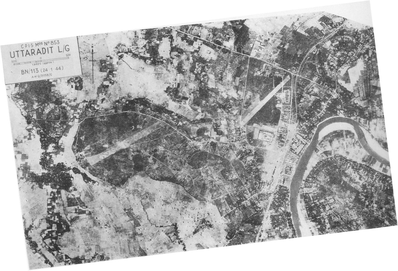
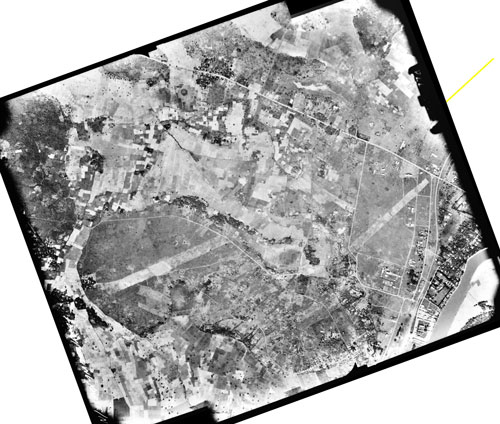
The aerial view, printed in a contemporary Airfield Report, is probably based on a series of aerial photos, just two of which are stitched together below to show the proximity of the two airstrips in greater detail:18
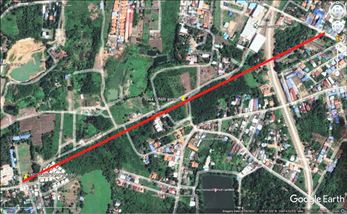
A present day Google Earth view shows the approximate locations of the two WWII airstrips in Uttaradit, outlined in red:19
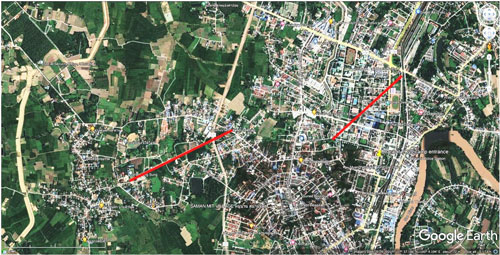
The following data were derived by applying Google Earth Path and Ruler tools to the map above:
NE runway
Nominal 3,500 feet
Heading: 05-23 (47.5°-227.5°)
NE end: N17°37.96 E100°05.95
SW end: N17°37.56 E100°05.50
SW runway
Nominal 4,300 feet
Heading: 06-24 (64°-244°)
NE end: N17°37.605 E100°04.820
SW end: N17°37.300 E100°04.160
To better locate the two old runways on current day features, a Google Maps view of the Uttaradit area was overlaid on the Google Earth view, again with runways marked in red:20
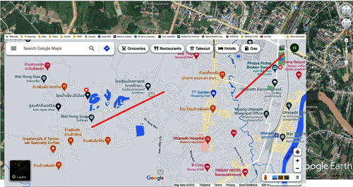
The Google Map view was then divided between the two runways which allowed an enlargement of surrounding features. The two maps directly below are matched in scale, and, as shown, the southwesterly runway was wider than the northeasterly one. Unfortunately Google Maps does not name most of the streets intersected by the runways.
Northeast runway shown in red on Google Map:21
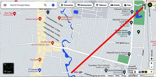
Nominal 3,500 feet
Heading: 05-23 (47.5°-227.5°)
NE end: N17°37.96 E100°05.95
SW end: N17°37.56 E100°05.50
No present-day evidence of this runway is believed to have survived on the ground.
Southwest runway shown in red on Google Map:22
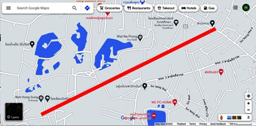
Nominal 4,300 feet
Heading: 06-24 (64°-244°)
NE end: N17°37.605 E100°04.820
SW end: N17°37.300 E100°04.160
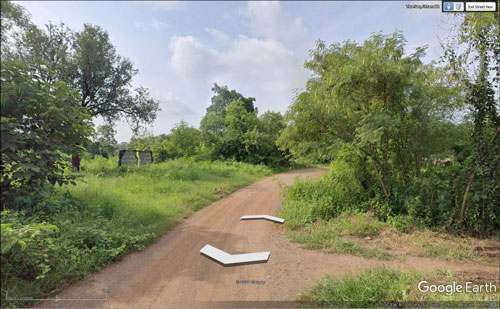
Note that the runway symbol above hides a road which, for the most part, may have followed the original runway:23
It is of dirt and of insufficient importance for Google Earth / Maps to offer a Street View for most of its length: what does show is a poorly maintained gravel roadbed:24
April 1944: Airfield Report No. 21 of April 1944 included a brief status on Uttaradit:25
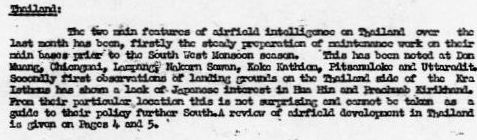
Transcript:
The two main features of airfield intelligence on Thailand over the last month has been, firstly the steady preparation of maintenance work on their main bases prior to the South West Monsoon season. This has been noted at Don Muang, Chiengmai, Lampang, Nakorn Sawan, Koke Kathiem, Pitsonuloke and Uttaradit.
25 July 1944: From Provisional Airfield List, Southeast Asia, Enemy Airfield Information Report No. 3, 25 Jul 1944, Thailand, p 70:26
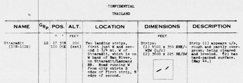
Transcript:
Thailand |
|
| Uttaradit (18N-101E) | |
| LG [Landing Ground with incomplete facilities or without all-weather runway] | |
| Position: | 17°38N 100°05E |
| Altitude: | 200 feet (est) |
| Location | Two landing strips, first just west and second 1 3/4 mi west of Uttaradit, which is on west bank of Nan River, on Uttaradit / Lampang RR. Road running west from city skirts south edge of first strip, north edge of second. |
| Dimensions: | Strips: 1) 4500 x 350 ENE/WSW (under construction) 2) 3600 x 225 NE/SW |
| Description: | Strip (1) appears unserviceable, rough and partly overgrown; being cleared and leveled. Strip (2) has hard-packed surface. (May 44) |
A key item to note here, as of Jul 1944, the ENE/WSW runway is described as “under construction”; hence, the NE/SW runway would have been the original runway. The second runway would not likely have been for cross-winds operations since its heading was so close to that of the existing runway. Perhaps its purpose was to provide an alternate runway in case the main runway was badly cratered in an attack. This would have been consistent with the IJA tactic of building “back-up” bridges, for both rail and road ways.27
In this schedule only, runway numbering was reversed; ie, “Dimensions” should have read:
Strips:
1) 3600 x 225 NE/SW
2) 4500 x 350 ENE/WSW (under construction)
In other words, Runway 1, the older runway, is the more easterly of the two.
28 Sep 1944: P-38s strafed the Uttaradit railway yard, and the markets at Bang Pho and Tha Sao.28
06 Oct 1944: A series of RAF attacks resulted in much damage to the Uttaradit Railway Station area and the loss of one RAF Liberator.29 The loss was attributed to two Thai Army flak wagons, ie, railway cars with anti-aircraft guns, located in a string of rail cars (carriages) in the railway yard.30
10 Oct 1944: An RTAF staff member arrived at Uttaradit to interrogate the two survivors of the RAF Liberator which had been shot down on 06 Oct 194431
21 Oct 1944: Description of Uttaradit air facilities (and typical hereafter to the end of the war)32
![]()
Transcript:
Uttaradit Landing Ground: Activity: Occasional cover during the month failed to disclose the presence of any aircraft. (21/Oct/44)
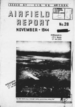 November 1944: Uttaradit had been judged significant in the April 1944 status report (above), and regardless of the null aircraft traffic there in October, a photo of the southwest runway appeared on the cover of the November 1944 issue of Airfield Report No 28. [14]
Of more interest is an enlargement of the cover photo, with this caption:33
The ENE WSW strip at Uttaradit landing ground, Siam, looking east.
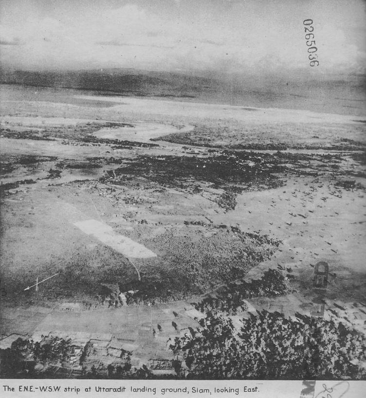
The other runway, Runway 1, is out of view to the left of this photo.
The November 1944 Airfield Schedule for Uttaradit Landing Ground34 repeated the information in the January 1944 Schedule, with the following changes / additions:
Serviceability: Dry-weather only. Heavy rains during SW Monsoon period May-October.
Installations: Temporary living accommodation in surrounding villages and in barracks on landing ground. Various airfield buildings.
[16 Nov 1944: Allies bombed Pak Nam Pho Railway Station.35]
16 Nov 1944: Six USAAF B-24s attacked Uttaradit Station area with 28 tons of 500-lb bombs causing serious damage and two aircraft were seriously damaged by ground fire.36
22 Mar 1945: USAAF B-24s bombed along the Northern Railway, doing considerable damage, including at two railway stations in Uttaradit.37
19 Apr 1945: This is the last status entry for Uttaradit Landing Ground:38
![]()
Transcript:
Uttaradit Landing Ground:
Activity: Frequent cover failed to reveal the presence of any
aircraft (19th April, 1945)
Serviceability: Both strips are reported disused.
| Issued for information only | ||
| p1: corrected; p2 added; for review | ||
| Converted to WordPress by Ally Taylor | ||
| Updated, author errors & typos corrected | ||
Last Updated on 3 January 2026
- BR Whyte, The Railway Atlas of Thailand, Laos and Cambodia (Bangkok: White Lotus Press, 2010), Date from p 24; RR Stationing from p 27.[↩]
- Railway stationing 509+36[↩]
- ibid, p 24.[↩]
- Sakpinit Promthep email of 02:57 14 Jun 23. The itinerary was:
Uttaradit, 12-15 Feb 1924
Chiang Mai, 16-19 Feb 1924
Lamphun, 20-23 Feb 1924
Chiang Rai, 24-27 Feb 1924
Lampang, 28 Feb-2 Mar 1924
Phrae, 3-6 Mar 1924 [↩] - Air Force Historical Research Agency (AFHRA) Reel B1750, p1716, Survey of Thailand (Washington: US War Department, 15 Mar 1941) Appendix I, page (unnumbered).[↩]
- ibid, p 1767.[↩]
- Air Force Historical Research Agency (AFHRA) Reel B1750, p1716, Survey of Thailand (Washington: US War Department, 15 Mar 1941), Appendix I, page (unnumbered).[↩]
- ibid, p 1813[↩]
- ประว้ติกองท้พอากาส ในสงครามมหาเอเชียบูรพา ระหว่าง พ.ศ.-๒๔๘๔-๒๔๘๘ (นครราชสีมา: สมบูรณ์การพิมพ์, พ.ศ.๒๕๖๔) [History of the Royal Thai Air Force during the Great East Asia War, 1941-1945 (Nakhon Ratchasima: Somboon Printing, 2021)] (hereafter, RTAF History), p 84[↩]
- RTAF History, p 136[↩]
- RTAF History, p 143[↩]
- RTAF History, p 151[↩]
- RTAF History, pp 168-282[↩]
- AFHRA Reel, A8055 p0399, Airfield Report No 18, (Jan 1944), p (unnumbered)
The title for this format eventually evolved to “Airfield Schedule”.
Ban Tha It and Ban Yang Gadai, used in the road description, could not be found; however, that road was said to form the north boundary of the landing ground, and could be present day Thai Intra-Province Route 1041 (see Wikipedia: Thai Highway Network, Highway Numbering (offsite link).[↩]
- AFHRA Reel, A8055 p0428, Airfield Report No 18, (Jan 1944), p (unnumbered): CIO (C.I.O.): Chief Intelligence Officer[↩]
- AFHRA Reel A8055 p0423. Airfield Report No 18, (Jan 1944), p (unnumbered).[↩]
- AFHRA Reel A8055 p0565. Airfield Report No 18, (Jan 1944), p (unnumbered) [↩]
- US National Archives, Film Can B7348 (30 Nov 1944) Mission 35PR/4MG49, Frames RV44 & RV46, obtained and processed by Matt Poole. Stitched with Microsoft Image Composite Editor (ICE), ver 2, and reoriented so that north is up-page by author using Microsoft Publisher.[↩]
- Google Earth view of Uttaradit, annotated by author using Microsoft Publisher.[↩]
- Google Map view of Uttaradit, superimposed on Google Earth view, using Microsoft Publisher, by author.[↩]
- Enlargement covering only the northeast runway in the marked up Microsoft Map image above.[↩]
- Enlargement covering only the southwest runway in the marked up Microsoft Map image above.[↩]
- Close-up of southwest runway on Google Earth. Markup by author using Microsoft Publisher.[↩]
- Street view in Google Earth of section of roadway on or adjacent to the probable location of the southwest runway.[↩]
- AFHRA Reel A8055, p0679, Airfield Report No 21 (Apr 1944), p 3[↩]
- AFHRA Reel A1284, p1349, Provisional Airfield List: Southeast Asia (25 Jul 44), p 70[↩]
- A similar cleared area is faintly visible to the east of the Chiang Mai airstrip in Photomosaic No. 1 (03 April 1944). While the established runway there is on heading 18-36, the cleared area is at 16-34.[↩]
- Wisarut Bolsithi in 2bangkok blog on Thai history, 0302 30 Oct 2008. Copied 18 Mar 2010 (no longer on-line).[↩]
- ibid; RTAF History, pp 230-233[↩]
- Sakpinit Promthep email of 01:49 15 Nov 2021.[↩]
- RTAF History, p 234[↩]
- AFHRA Reel A8055, p1020, Airfield Report No 27 (Oct 1944), p 10.[↩]
- Enhanced copy of photo in cover provided by Sakpinit Promthep email of 05:14 04 May 2022, attachment: Uttaradit LG-2.jpg[↩]
- AFHRA Reel A8055, p1069, Airfield Report No 28 (Nov 1944), p (unnumbered) [↩]
- Wisarut Bolsithi, ibid.[↩]
- RTAF History, pp 254-255.[↩]
- RTAF History, p 239[↩]
- AFHRA Reel A8056, p0166, Airfield Report No 33 (Apr 1945), p (3) [↩]