This page continues the chronological review of the development of air facilities in the Uttaradit area.
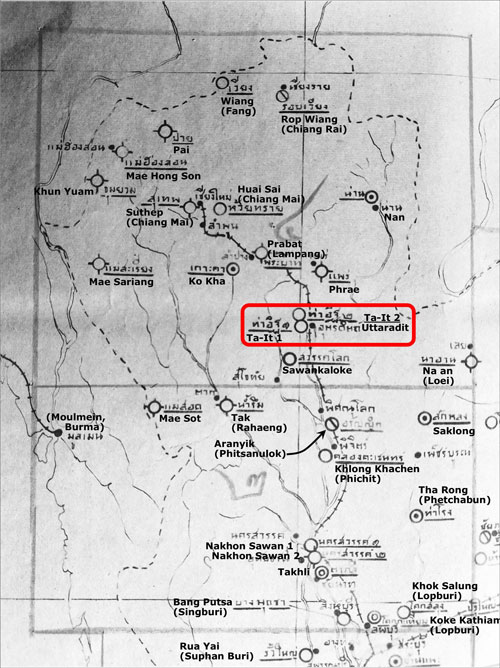
1953: Map of airfields in northern Thailand. Two items are shown for Uttaradit: Tha-It 1 and Tha-It 2. The town named Uttaradit covers the whole subdistrict or tambon of Tha It. Somewhat confusingly, the whole of the town of Uttaradit is located in the subdistrict of Tha-It which is in turn located in the district named Uttaradit which is part of the province of Uttaradit:1
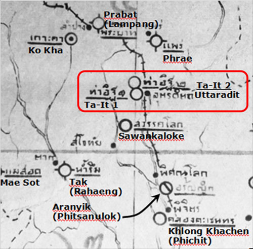
Uttaradit entries enlarged:2
While the airstrips photographed by the USAAF during 1944 were roughly on an east-west axis, the two airstrips in 1953 are depicted in a roughly north-south orientation. In addition, the numbering is from south to north
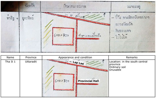
1954: A Royal Thai Air Force unpublished document3 listed these two air facilities in the Uttaradit area.
Airfield No. 1, with translation:4
This might have been a schematic rendering of what was the northeast runway in 1944; but very few facilities in the document were depicted in what might be a schematic fashion. This might also have been an attempt to retreat to an earlier approach to airfield design. Some of the earliest airfields were just large flat areas, often circular, with a wind sock present to help pilots land into the wind, from whichever direction it came. However, it was soon found that local winds usually came from a very limited number of directions, as “prevailing winds”. Limiting the grooming of land to those directions proved more efficient than maintaining larger expanses, most of which were not used. Increases in requirements for takeoff and landing lengths pressed airfield managers to trim back airfields to strips of land, airstrips, if you will. Increases in land costs and the expense of paving airstrips further motivated using the airstrip / runway approach.5
Airfield No. 2, with translation:6
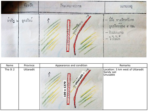
At this time, the location of this airstrip is unknown. The map shows a runway adjacent to a road curving northeast towards Uttaradit, while the “Remarks” locate it as 5 km west of Uttaradit. The second runway in 1944 was roughly aligned ENE-WSW while this runway is shown as north-south and it was about two kilometers west of Uttaradit, not the five specified here.
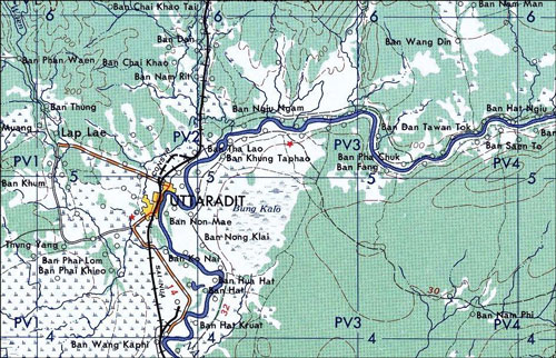
1956: US Army map, NE47-11, “Uttaradit”, shows no air facilities in the Uttaradit town area:7
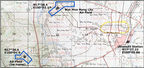
1969: Royal Thai Survey Department (RTSD) map 5044 III, “Changwat Uttaradit”,8 shows three air facilities in the Uttaradit area. All three are documented for the first time in 1969. Note that the scales differ on the two extracts presented below, but the grids in both cases represent one-kilometer squares.
To the west of Uttaradit proper were two air facilities:9
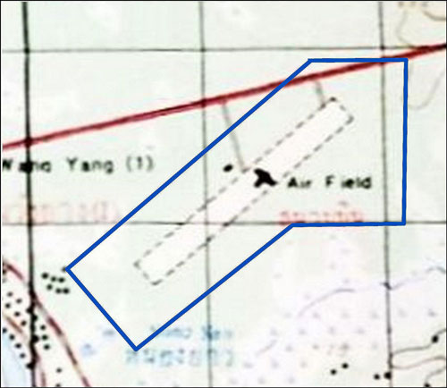
1. Northwest (NW) airfield10 (Google Maps link) entry enlarged:11
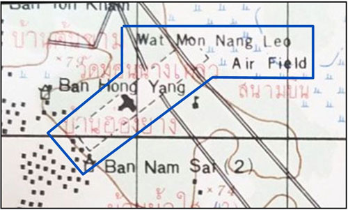
The airstrip scales to 3,300 feet long x 600 feet wide on a heading of 05-23. The Wat Mon Nang Leo is probably a very rustic Wat Mon Na Liao,12 (Google Maps link) north off the SW corner of the airfield.
2. Southwest (SW) airfield13 (Google Maps link) entry enlarged:14
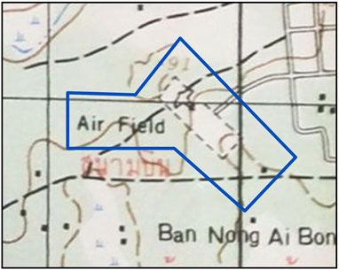
The airstrip scales to 1,500 feet x 450 feet wide on a heading of 13-31. The two airstrips showing west of Uttaradit in 1969 were almost perpendicular in headings. Approximate location per Google Earth: N17°36.58 E100°01.91
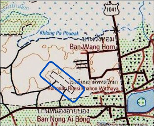
3. To the ENE of Uttaradit proper, about 15 km, is a single air facility, NE airfield15 (Google Maps link):16
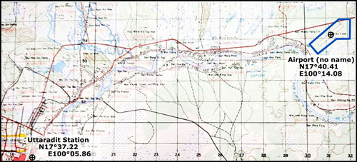
Northeast (NE) airfield entry, titled Airport (no name), enlarged:17
The airstrip scales to 4,900 feet long x 450 feet wide on a heading of 05-23, the same heading as the NW Airstrip. Approximate location per Google Earth.
1971: Air America (AA) periodically published a listing of airfields available in Thailand. This is the first listing of air facilities in the Uttaradit area using ICAO four-character identifiers.18
515 Uttaradit (VTCF):19
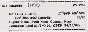
The 515 is a number assigned by Air America; the VTCF a designator by ICAO. The airstrip bearings / headings are the same as that of the 1969 Wat Mon Na Liao Air Field. For coordinates, AA would have been using the Indian datum coordinate system which differed from the WGS84 standard used by Google Earth.20 That, along with pre-GPS methods less accurate than required today, could explain the differences in coordinates cited: N17°38.35 vs N17°40 and E100°02.83 vs E100°06.
The designator is still listed by the ICAO, though there is no location noted.
67 Uttaradit East (VTCU):21
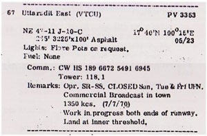
Again, the prefix number is an Air America artifact. As above, approximations of heading plus runway length can imply that it is the same as the unnamed 1969 Air Field at about N17°40.41 E100°14.08. The ICAO does not list a VTCU, but rather a VTPU for Uttaradit; so VTCU is apparently an error.
Neither air field has any active NOTAMs as listed by the FAA22 which implies that the fields are not active.
1973: From US Army Map Service map NE 47-11:23
Two airfields are shown, with minimal information:
-
- Uttaradit Northwest, runway 2900 feet long, with unknown surface, elev 269.
- Uttaradit East, runway 5000 feet long, runway surface material not specified, elev 265
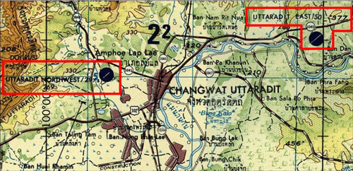
1983: From Tactical Pilot Chart TPC J-10C:24
Key
-
-
- Open circles indicate minor airfield; ie, less than 3,000 feet long.
- Solid circle indicates airfield with runway over 3,000 feet long;
- A line in the circle shows the approximate alignment of the runway.
- /s following airfield name indicates sod runway
- Bold number below name is elevation
- In the case of UTTARADIT, the number 285 to the right of the airfield symbol indicates elevation
- NDB above airfield name: non-directional beacon
-
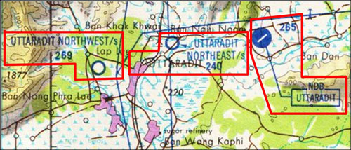
Using this map, Hebel updated Uttaradit area air facilities to 2007, listing:
UTTANW Uttaradit North West (Google Maps link) Closed
ELEV 270″
N17 38 18 E100 03 02
RWY 05 – 500 m: 23 – 500 m
Might be VTCF?
UTTANE Uttaradit North East (Google Maps link) Closed
ELEV 240′
N17 39 45 E100 08 30
RWY Unknown
VTPU Uttaradit (Google Maps link) Closed
ELEV 262′
N17 40 25 E100 14 09
RWY 05 – 1,500 m: 23 – 1,500 m
While Uttaradit Northwest and VTPU Uttaradit go as far back as (at least) 1969, Uttaradit Northeast appears only on this 1983 TPC. This TPC has only been updated by NOTAMs25 since 1983 and now there are no NOTAMs outstanding for any facilities in Uttaradit.
To locate Uttaradit NE, a railway bridge26 (Google Maps link) just to the west of Uttaradit NE was used as reference. In the area where the air facility was shown is today the 9-hole course of the Pi Chai Dap Huk Golf Club. With the wildly meandering watercourse of the Pheung Cannal / Nam Rit passing through the area, it doesn’t seem to have ever been a practical location for an air facility.
2007: Views of previously located facilities.
Google Earth view of Northwest (NW) airfield27
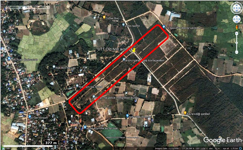
which will be followed by future development (see below).
Google Earth view of Southwest (SW) airfield13 (Google Maps link) :28
(that view remains essentially the same in May 2022)
RTSD view of same SW Airfield:29
Somewhat oddly, the RTSD map continued to call out the airstrip, though it had long been out of service (if indeed it ever had been used).
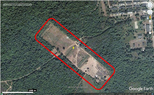
Google Earth view of (Northeast NE) airfield15 (Google Maps link):30
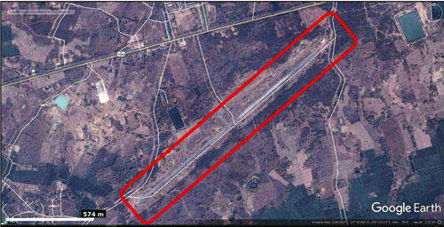
(that view remains essentially the same in May 2022)
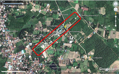
2021: The only significant change to a former airfield site that can be seen via Google Earth currently is continued development at the location of the former NW Airfield:31
Significant features on the west and north sides of Uttaradit town, with the four WWII former airstrips highlighted in red:32
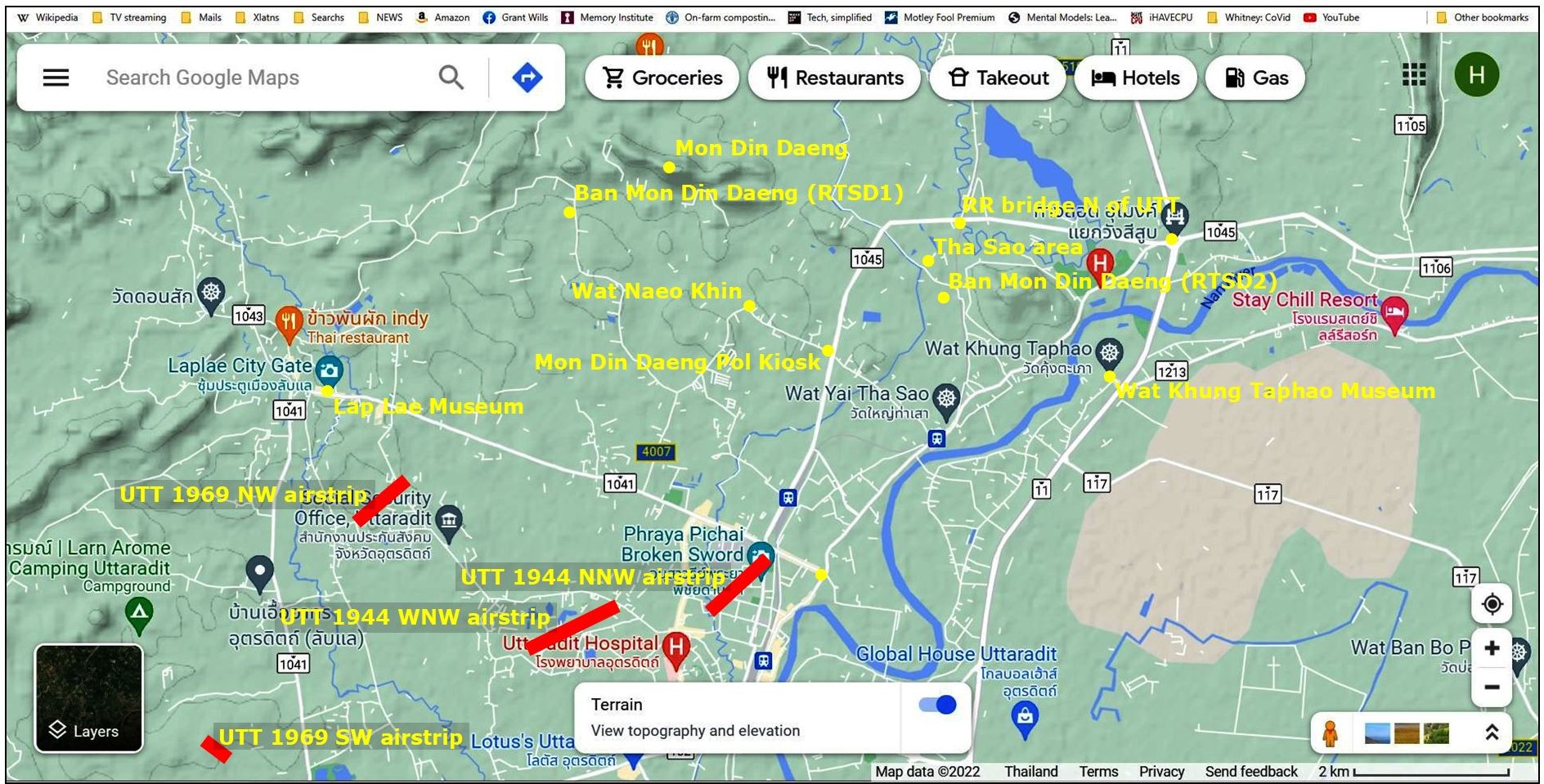
The more permanent appearing, though long inactive, Uttaradit Northeast air strip, post-World War II, is off the map to the east (right).
Last Updated on 3 January 2026
- see Uttaradit administration (offsite link). Map source: Map of Northern Thai airfields dated 1953; provided by Sakpinit Promthep email 08:51 06 Feb 2021 as att, “Northern Afld-p09.jpg”; my ref: \02370 Other locations\02370 Uttaradit, Dara\_Northern Afld-p09 MAP markup.jpg[↩]
- My ref: part of Map of Northern Thai airfields dated 1953; provided by Sakpinit Promthep email 08:51 06 Feb 2021 as att, “Northern Afld-p09.jpg”; \02370 Other locations\02370 Uttaradit, Dara\_Northern Afld-p09 MAP markup.jpg: IMG_1028,airfield_or_airfields extr.jpg[↩]
- แผนผังสัง เขปสนามปินทั่วราชอาณาจักรไทย (Maps of airports in Thailand (?: unpublished, 1954), p 6. Provided per Sakpinit Promthep email of 08:51, 06 Feb 2021[↩]
- My ref:\02510 Air facilities, TH\Breakouts\Uttaradit\1954 RTAF\Uttaradit 1954.pub, sht 1; Uttaradit-1 1954.jpg[↩]
- “The world’s first runways . . . were circular. . . . sometimes . . . early airports were square rather than round. Near my home is a large square park which was at one time just such a facility. It measured one mile on each side, and is today called “Mile Square Park”.” (Ron Rapp, “The Circular Runway” (offsite link), apparently speaking of Orange County, California) [↩]
- My ref: \02510 Air facilities, TH\Breakouts\Uttaradit\1954 RTAF\Uttaradit 1954.pub, sht 2; Uttaradit-2 1954.jpg[↩]
- Extract from Series L509, Sheet NE47-11, Edition 1-AMS “Uttaradit”, (offsite link; First Printing 8-58). US Army Service, Compiled from 1955, 1956 data. Scale 1:250,000. Gridlines are spaced at 10 km. Downloaded from University of Texas, Perry-Castañeda Library Map Collection Thailand Maps.[↩]
- Royal Thai Survey Department (RTSD) Series 7017 Map 5044 III, Changwat Uttaradit, Map information defined as obtained in 1969. Photographed at Chiang Mai University Library, 31 Apr 2022.
Markups by author using Microsoft Publisher.
Coordinates and dimensions per scaling Google Earth images. Note that airstrip widths shown may be sized to incorporate the airstrip symbol.[↩]
- My ref: \02510 Air facilities, TH\Breakouts\Uttaradit\1969 RTSD UTT\RTSD 1969 Uttaradit area.pub, sht 3; Uttaradit RTSD 1969-1 & 2 markup[↩]
- N17°38.4 E100°03.16 per Google Earth[↩]
- My ref: \02510 Air facilities, TH\Breakouts\Uttaradit\1969 RTSD UTT\RTSD 1969 Uttaradit area.pub, sht 5; Uttaradit RTSD 1969-1.jpg[↩]
- N17°38.35 E100°02.83[↩]
- N17°36.6 E100°01.9[↩][↩]
- My ref: \02510 Air facilities, TH\Breakouts\Uttaradit\1969 RTSD UTT\RTSD 1969 Uttaradit area.pub, sht 4; Uttaradit RTSD 1969-2.jpg[↩]
- N17°40.41 E100°14.08[↩][↩]
- My ref: \02510 Air facilities, TH\Breakouts\Uttaradit\1969 RTSD UTT\RTSD 1969 Uttaradit area.pub, sht 6; Uttaradit RTSD 1969-3 markup.jpg[↩]
- My ref: \02510 Air facilities, TH\Breakouts\Uttaradit\1969 RTSD UTT\RTSD 1969 Uttaradit area.pub, sht 7; Uttaradit RTSD 1969-3a.jpg[↩]
- Air Facilities Data Thailand 432 (booklet) dated 01 Feb 1971.
515 Uttaradit (VTCF), p 43.
67 Uttaradit East (VTCU), pp 21, 22.This is the only version of this document that I have; ie, there are probably earlier versions.[↩]
- My ref: \02510 Air facilities, TH\Breakouts\Uttaradit\1971 AA\Uttaradit AA 515 breakout.jpg[↩]
- The RTSD map for the Uttaradit area carries the note:
Coordinate conversion
WGS 84 to Indian 1975:
Geographic:
Add 11.9″Long [370 m] Subtract 4.9″Lat [147 m][↩] - My ref: \02510 Air facilities, TH\Breakouts\Uttaradit\1971 AA\Uttaradit AA 067 breakout.jpg[↩]
- website, < https://www.notams.faa.gov/dinsQueryWeb/queryRetrievalMapAction.do > no longer available[↩]
- Extract from Series 1501 AIR, Sheet NE 47-11, Edition 2, “Changwat Uttaradit”, Scale 1:250,000 (as NE47_11c & d stitched by author). US Army Service, Compiled July 1973. Scale 1:250,000. Gridlines are spaced at 10 km. Downloaded May 2014 from University of Texas, Perry-Castañeda Library Map Collection Thailand Maps: links apparently now no longer available; my ref: \02510 Air facilities, TH\Breakouts\Uttaradit\1973\UTT 1973 markup.pub, sht 1.[↩]
- Extract scanned from TPC J-10C, Burma, Laos, Thailand, Edition 4, Scale 1:500,000. Compiled Aug 1969, revised Jul 1983 by Defense Mapping Agency, Aerospace Center. Hardcopy purchased from Stanfords London, c1998; my ref: \02510 Air facilities, TH\Breakouts\Uttaradit\1983 TPC\1983 three facs.pub, sht 1.[↩]
- Per note on TPCs, “Consult NOTAMS and Flight Information Publications for the latest air information . . . .” NOTAM: “. . . Notice to Air Men, officially, “a notice filed with aviation authorities to alert pilots of potential hazards along a flight route or at a location that could affect the flight. Wikipedia NOTAM. (offsite link) [↩]
- N17°40.356 E100°07.344[↩]
- N17°38.4 E100°03.16; extract from Google Earth dated 2007, marked up by author using Microsoft Publisher; my ref: \02510 Air facilities, TH\Breakouts\Uttaradit\2007 GE\2007.pub, sht 7.[↩]
- Extract from Google Earth dated 2007, marked up by author using Microsoft Publisher; my ref: \02510 Air facilities, TH\Breakouts\Uttaradit\2007 GE\2007.pub, sht 4.[↩]
- Extract from RTSD 7018 Map 5044 III, Changwat Uttaradit, displaying information from 2007, marked up by author using Microsoft Publisher; my ref: \02510 Air facilities, TH\Breakouts\Uttaradit\2007 GE\2007.pub, sht 6.[↩]
- Extract from Google Earth dated 2007, marked up by author using Microsoft Publisher; my ref: \02510 Air facilities, TH\Breakouts\Uttaradit\2007 GE\2007.pub, sht 1.[↩]
- Extract from Google Earth dated 29 Sep 2021, marked up by author using Microsoft Publisher; my ref: \02510 Air facilities, TH\Breakouts\Uttaradit\2021 GE\2021 views.pub, sht 1.[↩]
- Extract from Google Maps marked up by author using Microsoft Publisher; my ref: \02510 Air facilities, TH\Breakouts\Uttaradit\_Uttaradit study\Uttaradit.pub, sht 20[↩]