This page discusses aerial photographic intelligence found in US Government archival systems.1
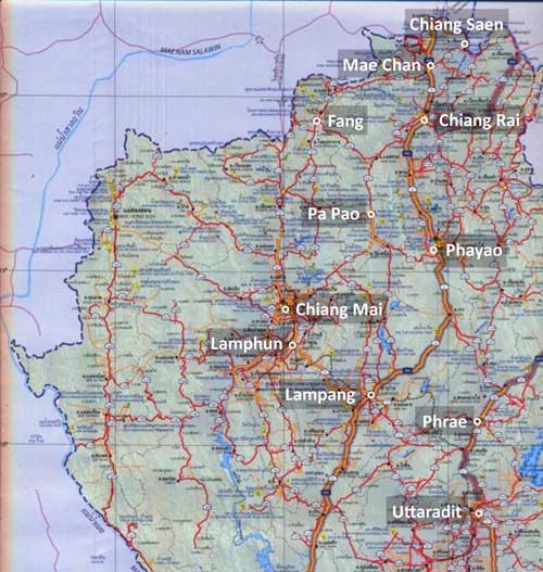
In northwest Thailand, the following general areas are reported to have been covered by aerial photo surveillance per flight records of Photographic Reconnaissance Squadrons (PRS) in the US Army Air Force (USAAF):2
This section presents aerial photo flight records from those PRSs. Currently only flight reports are displayed, not matching aerial photos. If corresponding photos are discovered, they will be added to this page. This discontinuity exists because the two items are separately maintained:
Flight records are maintained by the US Air Force Historical Research Agency (AFHRA) at Maxwell Air Force Base in Montgomery, Alabama; this agency is the primary source via CD copies. In addition, some commercial websites offer limited selections, apparently obtained from AFHRA.
Aerial photos are maintained by the US National Archives and Records Administration through the Department of Defense; a guide for using NARA WWII aerial imagery, generated by Matt Poole is available in the Appendix.3 Secondary sources seem to be currently one, with excellent quality, though very limited selection: Fold3 (offsite link, requires subscription).
Locations in northwest Thailand covered by USAAF photo reconnaissance include:
Ban Dara Bridge
Chiang Mai
Chiang Rai
Kaeng Luang Bridge*
Hang Chat**
Koh Ka**
Lampang**
Lamphun*
Mae Hong Son*
Mae Mo**
Nan
Phayao
Phrae
Sop Pat
Uttaradit
For asterisked topics (* and **), aerial photo flight records were integrated with all other information available about the subjects.
* These locations are also listed on the home page.
** These locations are a subcategory of Lampang Airfield Group
which is listed on the home page.
Corrolation of USAAF aerial photos with flight reports
The following may appear confusing because I don’t yet have a specific example of an aerial photo flight report that matches an actual photo in hand. But I include it nonetheless to record how to interpret some of the identifying information provided on some aerial photos.
The abbreviation, “PR” or “PRS”, in the handwritten annotation on an aerial photo is an abbreviation for Photographic Reconnaissance / Squadron, an organizational unit in the US Army Air Force (USAAF). It will typically be preceded by a number identifying the particular squadron; eg, 9, 35, 40, etc.
The photos for one of the aerial mosaics presented for Lampang (here) have these “identifiers” in the upper left corners. Note that these all attribute 40PRS:4
![]()
![]()
![]()
A typical USAAF aerial photo flight report from a different flight looks like this (I can find no photo requests which match the ID numbers above nor even a PRS aerial photo request from 40PRS):5
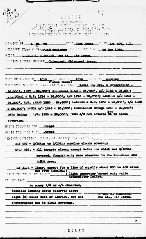
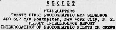
As noted above, the three “identifiers” from actual aerial photos show “40 PR” in the heading of the report; but no aerial photo requests from 40PRS have been found. As a result, a heading from a different PRS, in this case “TWENTY FIRST PHOTOGRAPHIC RCN SQUADRON”, or “21PR”, or 21PRS is shown as an example:6
The key item in the flight report above is “MISSION 4 MA 72”:7
![]()
This corresponds to “5 M 135” seen in the annotations illustrated above; ie, that was the mission number on which the photos were snapped.
As a result, unfortunately, without matching mission reports, USAAF aerials are otherwise unidentifiable.
To this point, the following PRS designations are known to have functioned over Thailand:
The source for USAAF flight reports are US Air Force Archives, and it has released a quantity of such reports which are included in the various sections which follow. Complicating matters, the actual aerial photos reported on are apparently maintained by the US National Archives and Records Administration (NARA), a separate governmental organization; while it has released many WWII aerial photos, the photos do not necessarily relate to the USAAF flight reports.
Appendix
The term, TRI-MET, appears frequently in aerial photo reports and is an abridgement of Trimetrogon. This is a “system of aerial mapping involving the use of a single assembly containing three cameras with which one vertical and two oblique right and left aerial photographs are taken simultaneously at regular intervals over the area being mapped”.11
Microsoft Image Composition Editor (ICE) is a useful computer tool for joining / stitching overlapping aerial photos together. Its use is discussed at ICE.
For accessing NARA-held documents, see: Matt Poole’s informal How to access the US National Archives and Records Administration (NARA) WWII aerial imagery.doc. He cautions that he wrote this guide in 2022 and, though there have been changes since then, his instructions may still be of help in accessing the current NARA system [Poole did not mention what impact Federal News Network‘s12 reported “budget proposal [to cut] 136 full-time employees across NARA” would have on his instructions.]
| First published on Internet | ||
| Definition of Trimet added. Respaced | ||
| Links, asterisked items modified | ||
| Note 9-series added | ||
| Converted to WordPress by Ally Taylor | ||
| Updated, author errors & typos corrected | ||
Last Updated on 20 February 2026
- Note that the current main source of actual aerial photographs of Thailand during WWII is the Williams-Hunt Aerial Photograph Digital Collection (no longer “on-line” 18 Dec 2025), most of which appears to be RAF in origin and is treated in some detail on this website at: Aerial Photomosaics based on Geo-spatial Digital Archive Project: The Williams-Hunt Aerial Photograph Digital Collection (no longer “on-line” 18 Dec 2025).[↩]
- Per the US Air Force Historical Research Agency. Aerial photo unit records covering northern Thailand are currently limited to 21PRS starting in January 1944 (part of the unit was assigned on 12 Jul 1943 to Kunming from where it would have provided coverage of Thailand (see “21st Photographic Reconnaissance Squadron” at US Air Force History Index). One set of photos in the Williams-Hunt Collection are credited to 40PRS (see below). “Terrain” map from Nations Online Project: Searchable Map and Satellite View of Thailand using Google Earth Data (link no longer available). Annotation by author using Microsoft Publisher.[↩]
- Matt Poole generated this “How to access the US NARA” in 2022 and cautions that there have been changes in the NARA system, but that his instructions may still help in accessing the current NARA system[↩]
- Williams-Hunt Collection aerial photos of Lampang are shown here, and note that they are one of the very few USAAF aerials included in the Williams-Hunt Collection. For 1945, 40PRS flew F-5 aircraft based at the following locations in India starting at the dates shown:
• (09 Aug 44): Alipore
• 18 Jan 45: Cox’s Bazar
• 15 May 45: AliporeSource: US Army Air Force 1st-49th Squadrons 1941-1945.
See also Combat Squadrons of the Air Force World War II, 40th Photographic Reconnaissance Squadron (p 188).((Headings extracted from the images numbered 02556.jpg, 02557.jpg, 02558.jpg in Lampang; my ref: \02370 Other locations\02370 Lampang\WH\. . . top.jpg[↩]
- 21st Photo Squadron aerial photo flight report of 29 May 1944 (USAF archive microfilm reel A0878, p 10).
21st Photographic Reconnaissance Squadron (History and Lineage).
Combat Squadrons of the Air Force World War II, 21st Photographic Reconnaissance (p 169).[↩]
- ibid, heading extracted. [↩]
- ibid, “Mission No.” and “Unit” extracted.[↩]
- PRS 9 (offsite link): Wikipedia notes that unit operations included Thailand. No flight records are available from USAF archives.[↩]
- PRS 21: Numerous flight records are available on USAF archive microfilm reel A0878.[↩]
- PRS 40: Aerial photo margin annotations show that unit operations included Thailand. Wikipedia 8th Reconnaissance Group (offsite link) lists unit.[↩]
- Merriam-Webster (offsite link) [↩]
- The Federal News Network, “Former archivist raises red flags over NARA cuts“, 20 Jun 2025[↩]