1945: There were no reports in the US Army Air Forces in World War II Combat Chronology 1941-1945 of any action involving Lampang during 1945.1
Young explained:
Although Allied air raids continued into December, with fighters and heavy bombers flying twelve missions, there were no further encounters with the Thai Air Force. The lack of air activity was partly intentional; ostensibly a firm ally of Japan, the Thai Air Force now actively supported the Thai underground against the Japanese. For the next nine months, until Japan’s surrender in August 1945, the air force led a double life.2
Nonetheless, Young records further, in 1945, Allied air attacks:
. . . continued on the Bangkok-Chiang Mai rail line . . . . Allied bombing raids into Thailand took place every few days as the RAF and the USAAF continued to knock out key rail bridges and damage marshaling yards.3
Japanese Monograph No 177 in “Outline of 39th Army’s Operational Plan – early 1945”:
The 4th Division . . . will be stationed in the Lampang sector and an element in the Chiangmai sector to secure strategic areas in northern Thailand, and to prevent the invasion of northern Thailand by the Chungking Army and the British Indian Army.3
Conforming to this order was not possible until the 4th Division had completed its move from Sumatra on 10 June 1945. Supplementary orders issued below clarified.
A map of the Lampang Airfield Group was drafted during the month. The group consisted of Lampang and Ko Kha (Kohga) Airfields, plus Hang Chat (Hangsat) and Mae Mo (Memoh) Landing Grounds:4
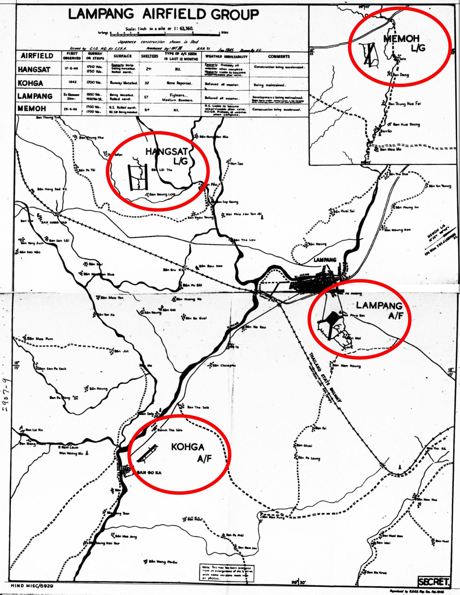
The table provided summary statistics for the four installations in the airfield group:5
The entry above for “Lampang” reads:
| Ex-Siamese site | |
| 1950 Yds; 1400 Yds u/c [under construction] | |
| Being metalled; Rolled earth | |
| 57 | |
in last 12 months |
Fighters Medium Bombers |
serviceability |
Believed all weather |
| Development being maintained. Note. Strip under construction is old ENE-WSW strip which has been revived and extended |
- The on, then-off, now-on-again, ENE-WSW runway: reported length increased from 1200 yards in October 1944 to 1400 yards in this January report.
- Shelters increased from 54 in April 1944 to 57.
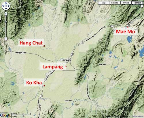
A different rendering of the Lampang Airfield Group, showed it all to be within the Wang River watershed:6
The first Airfield Report of January 1945 presented this detailed map sketch of Lampang Airfield (but dated 11 November 1944):7

Note that the sketch above is NOT oriented with north up-page, because considerable detail would be lost when necessarily reduced to fit on this page, nor is the extract of the sketch below. However, in most presentations, maps and photos have north up-page to provide conformity and to simplify comparisons.
Here the immediate airstrip area in the sketch above is enlarged to clarify original annotations:8

TRANSCRIPT of Legend:
Sketch Plan of LAMPANG A/F [Air Field] (SIAM)
18°16′ N 99°31’E
Map: Thailand Sheet 94N
[Scale]
BN/511 (11-11-44)
C-P-I-C/PLANS/319/1244 AC-S-E-A/3219/G
LANDING AREA:- Open grass land.
DISPERSAL:- Rolled tracks. The E[ast] area is still under construction.
AIRCRAFT SHELTERS:- About 57. – Construction continues. Some in the W[est] area appear derelict.
DEMOLITIONS:- All buildings of the living quarters NW [northwest] of the runway intersection reported under construction in Oct/43. (DIR No K 137) have now been demolished together with a number of smaller A/F [airfield] buildings in this area.
The huts in a line E[ast] of the runway intersection are probably workshops or possibly sheds for aircraft.
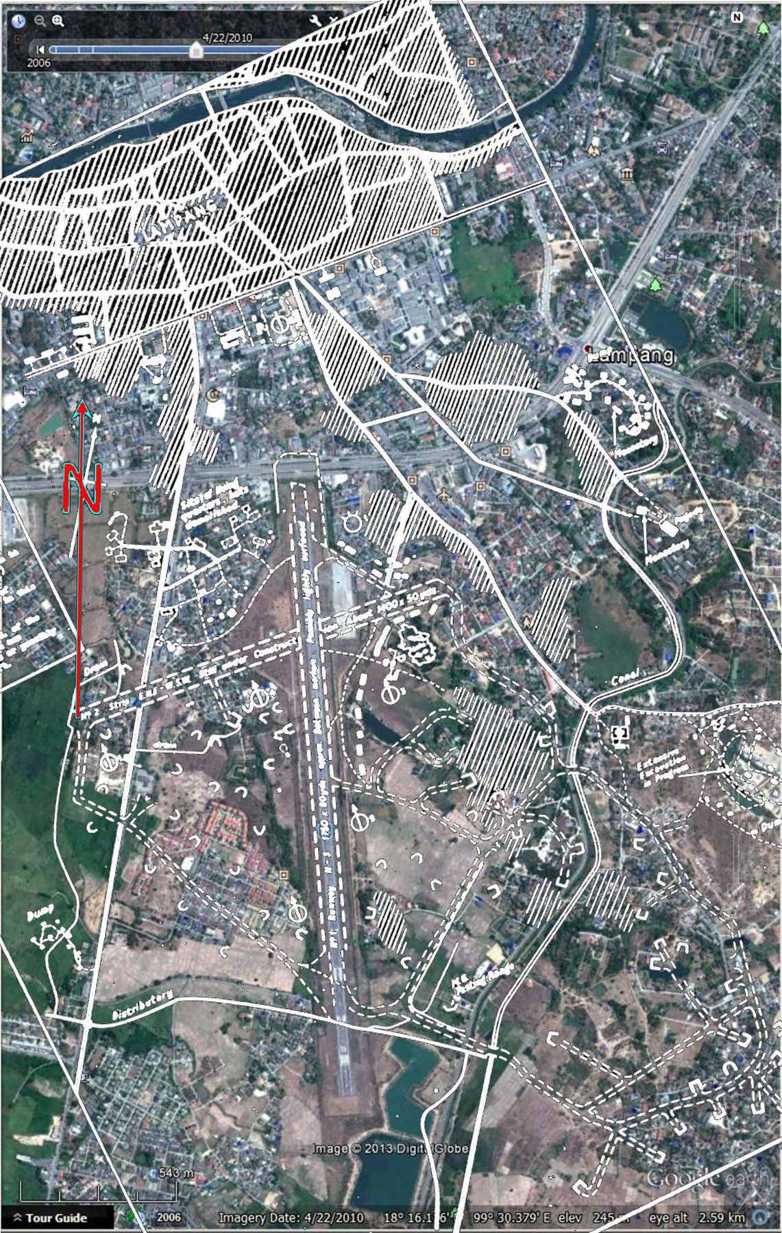
Overlaying the sketch above on a Google Earth view of the airport area does not produce a perfect match, but does give an idea of locations of the various details in 11 November 1944. It would appear that most, if not all, the aircraft shelters shown in the 19 May 1943 sketch had been relocated:9
Here is a comparison of the overlay above with the area of the first of a three photo sequence bomb photo series from June 1944. The area involved is outlined as a red rectangle in the aerial photo markup below:
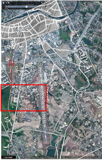
For the most part, general features on the ground can be related to symbols on the map sketch overlay. Red lines connect features to symbols in the two images:10
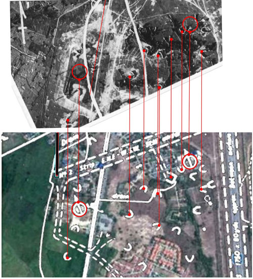
The symbols in the two areas circled in red above represent unoccupied gun emplacements. The various symbols above, looking similar to “U” or “V”, in different orientations represent single aircraft shelters. The one squared off symbol, “⊔”, shown just SW of the gun emplacement on the right, represents a shelter for two aircraft; while shown as a symbol on the sketch, that shelter does not appear in the aerial photo (which had been taken at least five months before the sketch was dated). The count for such shelters on the sketch was “about 57”. Needless to say, there is no evidence on the ground today of those structures.
For reference purposes, the following are enlargements of the two red‑circled areas in the aerial photo above; the circles surround symbols on the map sketch which signify unoccupied gun emplacements. No evidence of gun emplacements is apparent in the photo (again, the photo was taken some five months prior to the date of the map sketch):
 |
 |
| Emplacement 1 | Emplacement 2 |
The IJA invasion of India which had resulted in defeats at Imphal and Kohima six months before in July 1944 probably contributed to this Allied intel conclusion:11
TRANSCRIPT of relevant portion:
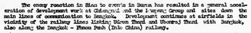
The enemy reaction in Siam to events in Burma has resulted in a general acceleration of development work at . . . the Lampang Group . . .12
TRANSCRIPT:
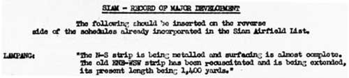
| LAMPANG: | “The N-S strip is being metalled and surfacing is almost complete. The old [original] ENE-WSW strip has been resuscitated and is being extended, its present length being 1,400 yards.” |
13 January 1945: No aircraft were observed at Lampang.13
![]()
TRANSCRIPT:
LAMPANG AIRFIELD:
Activity: Infrequent cover failed to reveal the presence of any aircraft.
Serviceability: The runways appear serviceable. (13/JAN/45)
24 March 1945: Again, no aircraft were observed at Lampang:14
![]()
TRANSCRIPT:
Lampang Airfield:
Activity: Frequent cover failed to reveal the presence of any aircraft. (24/MAR/45)
19 April 1945: And yet again, no aircraft were observed at Lampang; but curiously, construction work was reported:15
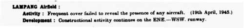
TRANSCRIPT:
LAMPANG Airfield:
Activity: Frequent cover failed to reveal the presence of any aircraft. (19 April 1945)
Development: Constructional activity continues on the ENE-WSW runway.
10 June 1945: Per Japanese Monograph No 177, within the IJA’s [Siam] Garrison [Command]:
The movement of the 4th Division from Sumatra to Bangkok, via Malay by rail, began in February 1945 but was not completed until June. The main body of the division proceeded to northern Thailand by motor transport to prepare for subsequent operations.16
(At that time the Thailand railroad was operative only in sections as most of the important bridges had been destroyed by Allied air attacks from bases in India. Most of the locomotives in northern Thailand had been destroyed and this part of the railroad had virtually ceased to operate.17 )
In the northern Thailand area, the main body of the 4th Division was ordered to stoutly defend the area around Lampang and elements were to construct defense positions so as to defend in depth the Lampang-Chiang Mai Road and the Lampang-Luang Nuea Road.18
Per the British record:
On the 10th June 1945 [IJA] 39th Army began to tighten its hold on Siam. Unwanted airfields were put out of action, defences were prepared at Bangkok and Lampang, and measures were taken to protect key roads.19
Functionality of the airfield at Lampang would probably have been maintained in keeping with its key position in the defense of Thailand.
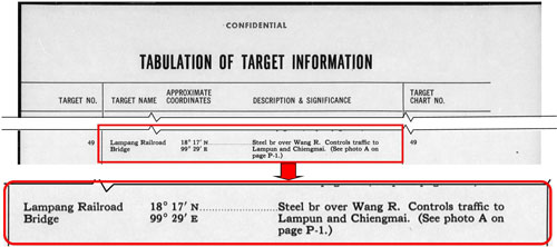
20 June 1945: Two bridges in Lampang City were listed in an Air Target Index for 20 June 1945:20
The main railway bridge, “the Black Bridge” (Google Maps link), over the Wang River:
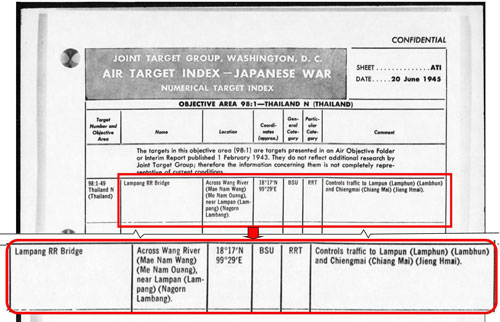
The railway bridge across the Wang at Lampang looks like an industrial grade, standard through-truss structure:21
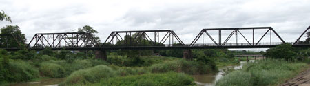
The “Black Bridge” (a common nickname for railway bridges in Thailand) was regularly targeted during the war, and damaged; but not sufficiently to require replacement. Repairs sufficed until the trusses were replaced in 1964 to increase load capacity.22
and a narrow road bridge also spanning the Wang River:
The photogenic bridge pictured below, the second of the two bridges identified, is captioned:
Lampang TARGET 49 Railroad Bridge> looking NE
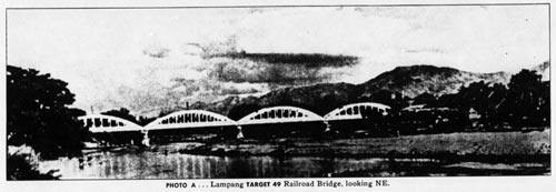
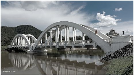
It is actually the Ratchadaphisak (สะผวนรัษฎาภิเสก) (Google Maps link), a narrow vehicle bridge crossing the Wang River about 5 km upstream of the rail crossing. Constructed of reinforced concrete which gave it a signature white color, it looks basically the same today.23
Curiously there is a railway bridge (Northern Railway Line Stn ~690+360) constructed of reinforced concrete24 and similar in appearance to the Ratchadaphisak, though of only two spans. However it located on the far side of Khun Tan Ridge towards Lamphun, about 60 km northwest of Lampang — the Chomphu White Bridge (Google Maps link):
This bridge crosses the Mae Nam Thai near Ban Tha Champhu Rail Station (Northern Railway Line Stn 691+89).
As conspicuous as both were with their white color, neither bridge was recorded as having been attacked.
30 June 1945: In Lampang, per Japanese Monograph No 177:
The main body of the [IJA] 4th Division was disposed in northern Thailand by the end of June and generally had completed construction of the positions in strategic sectors.25
02 July 1945: A USAAF P-38 inspecting Lampang was hit by ground fire and crashed. The pilot, Theodore Demezas, successfully parachuted out, to be taken prisoner and sent to a camp in Bangkok.
07 July 1945: The IJA unit in overall charge of Thailand, the 39th Army (known before 08 December 1944 as the Siam Garrison Command, was again renamed, this time as the 18th Area Army (offsite link).
In early July, the [IJA] 15th Army (offsite link) headquarters moved from Bangkok to Lampang in northern Thailand . . .26
As such, the unit was absorbed as a subsidiary unit into the 18th Area Army.
Mid-July 1945: From Japanese Monograph No 177:27
“Outline of [the IJA] 18th Army’s Operation Plan” included:
. . . Powerful groups capable of securing the strategic areas of northern Thailand without outside support will be stationed in northern Thailand to hold the enemy at bay.
” Disposition of forces” included:
15th Army Headquarters, 4th Division (less 61st Infantry Regiment and two artillery battalions, and 56th Division.
The 15th Army will defend strategic sectors in northern Thailand without outside support. . . . The 56th Division will . . . secure the vicinity of Lampang . . . .
“Traffic” included:
The main roads . . . to be secured. . . . As much as possible of the actual road construction as possible will be assigned to Thailanders. . . .
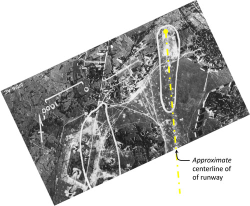
?? August (?) 1945: Sometime near the end of the war (date uncertain), the 40th Photographic Reconnaissance Squadron (40PRS) took three high altitude photos of general Lampang area. See Photomosaic No. 2 at:
Lampang Williams‑Hunt Aerial Photomosaic
15 August 1945: The 15th Army was demobilized at Lampang,28 and its parent organization, the 18th Area Army, was demobilized at Bangkok.
03 September 1945: Because a major IJA headquarters had been located in Lampang, the town was designated a center for concentrating IJA troops following the surrender by Japan. The 18th Area Army estimated the IJA 4th Division had two regiments, shared between Chiang Mai and Lampang.29
19 September 1945: British Army 7th Divisional Artillery took over responsibility for administering the surrender of IJA troops in the Lampang area.30
Mid-November 1945: “Preliminary” concentrations of IJA troops were complete throughout Thailand and movement by rail to holding camps around Bangkok began in preparation for return to Japan by ship.28
RTA, and presumably RTAF, personnel who had ended the war in Kengtung did not fare so well: RTAF aircraft which could not be flown out of Kengtung were intentionally destroyed on the ground to prevent them falling into Chinese hands.31 Thai troops proceeded on foot down the roads connecting Kengtung to Phitsanulok. Long neglected and poorly equipped, the units returned barefoot to Lampang; between there and Phitsanulok, the Thais continued to march barefoot as they watched railcars transporting IJA troops heading south. At Phitsanulok, Thai troops were finally given access to rail transportation.32 But some RTA troops were luckier and, after walking from Kengtung to Mong Hpayak, were trucked to Lampang where the more resourceful went to the railway yard and broke into boxcars for the trip south33.
Next: Lampang Airport: Casualties
Last Updated on 20 February 2026
- Carter, KC and R Mueller, compilers, Combat Chronology 1941-1945: US Army Air Forces in World War II (Washington: Center for Air Force History, 1991).[↩]
- Young, Aerial Nationalism (Washington: Smithsonian, 1995, pp 205-206. (emphasis added).[↩]
- Young, ibid, p 211.[↩][↩]
- Airfield Report No 31, Feb 1945, unnumbered pages, dated Jan 1945 (USAF Archive microfilm reel A8056 pp0003-0006). Note that map carries the date “Jan 1945” Runways at Lampang and Ko Kha were labeled “airfield” indicating Allied intel believed that all support facilities were available there, whereas Hang Chat and Mae Mo were classified as “landing ground”, providing more an emergency / backup function.[↩]
- ibid (extract) [↩]
- “Terrain” map from Nations Online Project: Searchable Map and Satellite View of Thailand using Google Earth Data (site no longer active). Annotations by author using Microsoft Publisher.[↩]
- Airfield Report No. 30, Jan 1945, unnumbered page (USAF Archive microfilm reel A8055 p 1202). See Appendix B. Notes on symbols used in USAAF airfield sketches.[↩]
- ibid. Annotations by author using Microsoft Publisher.[↩]
- Image consists of: Google Earth Imagery data centered on N18°13.136′ E99°30.379. Overlay as recorded above, processed with Adobe Fireworks and added with PhotoShop.[↩]
- Image consists of: Extract from Google Earth centered on N18°13.136′ E99°30.379 from overlay as recorded in note 47 above, processed with Adobe Fireworks and added with PhotoShop. Extract of aerial photo. Annotation added by author using Microsoft Publisher.
 [↩]
[↩] - Airfield Report No. 30, Jan 1945, “A Survey of Present and Future Trends in Japanese Airfield Development”, p i (USAF Archive microfilm reel A8055 p 1242).[↩]
- ibid, p 12 (USAF Archive microfilm reel A8055 p 1276).[↩]
- Airfield Report No. 30, Jan 1945, “Record of Airfield Activity and Development”, p 7 (USAF Archive microfilm reel A8055 p 1270).[↩]
- Airfield Report No. 32, Mar 1945, “Record of Airfield Activity and Development”, p 7 (USAF Archive microfilm reel A8056 p 0126).[↩]
- Airfield Report No. 33, Apr 1945, “Record of Airfield Activity and Development”, p 3 (USAF Archive microfilm reel A8056 p 0165).[↩]
- Japanese Monograph No 177: Thailand Operations Record, p 22.[↩]
- ibid, footnote 20[↩]
- Japanese Monograph No 177, ibid, p 27.[↩]
- Kirby, S Woodburn, The War Against Japan, vol 5 (Uckfield: The Naval & Military Press Ltd, 2004) p 292.[↩]
- Excerpted from three pages in NARA Publication Number M1653: WWII Japanese air target analyses, objectives, and aerial photographs, 1942-45, from the records of the U.S. Strategic Bombing Survey.
1. Roll 01, Sect 1-a, Item 2 (Fold 3: requires subscription)
2. Roll 05, Sect 1-d, Item 42 (Fold 3: requires subscription)
3. Roll 05, Sect 1-d, Item 42 (Fold 3: requires subscription)The Ratchadaphisak road bridge:

(Photo extract from “Lampang Province”, Wikipedia. This bridge location N18°17.58 E99°30.05 per Google Earth.
The bridge was erected in 1918, replacing a two-span wooden structure which had been destroyed by teak logs floated down the river by logging companies (Oliver Backhouse email of 0358 11 Mar 2016).)
While printed matter here is dated 20 June 1945, NARA ref cards date all three documents as 01 Feb 1943.[↩]
- DSCF1588 of 25 Jul 2013 by author. Bridge: railway station 643+470 (per Whyte, p 28).[↩]
- Wisarut Bholsithi email of 12 Sep 2018[↩]
- Photo extract from “Lampang Province” (offsite link), Wikipedia This bridge location: N18°17.58 E99°30.05 per Google Earth.
The Ratchadaphisak was erected in 1918, replacing a two-span wooden structure which had been destroyed by teak logs floated down the river by logging companies.((Oliver Backhouse email of 0358 11 Mar 2016[↩]
- Because of the typically heavy loading and vibration of locomotives and their cargo cars, concrete is very rarely used for railway bridges; this exception was the result of a severe shortage of steel caused by World War I.[↩]
- Japanese Monograph No. 177: Thailand Operations Record, p 34.[↩]
- Japanese Monograph No 177, ibid.[↩]
- Japanese Monograph No 177, pp 31-33[↩]
- ibid.[↩][↩]
- Kirby, ibid, p 295.[↩]
- ibid, p 296.[↩]
- Need reference.[↩]
- Wisarut Bholsithi in Axis History Forum’s “Thailand in WWII photos” on Forum message 03:02 22 Jun 2009 (offsite link) [↩]
- See World War 2 Veteran Feuay Dtang-rid comment about At war’s end[↩]