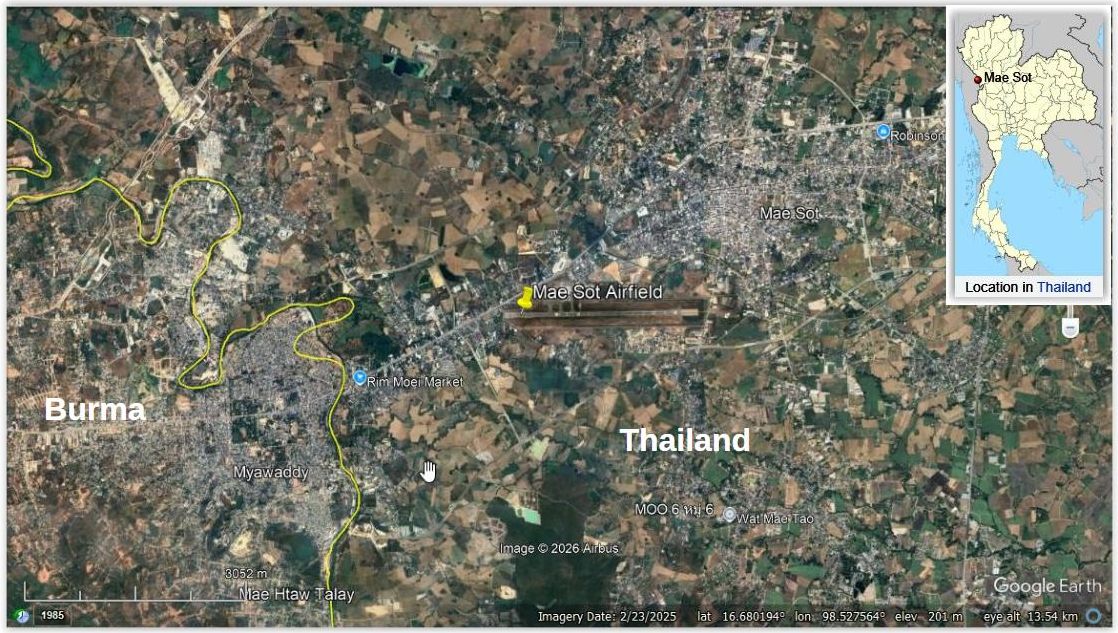
MAE SOT AIRFIELD:1 (Google Maps link) Mae Sot (aka, Mesod, Maesod, Mesoht, Mesawt) was long isolated from Tak and the rest of Thailand by an extension of the Thanon Thong Chai Mountain Range from Doi Inthanon, the highest point in Thailand. The ruggedness of that intervening mountain range proved too challenging for building a viable road to Mae Sot until the 1950s. Its nationality was secured by location on the east bank of the Moei River which had been designated a national border with British Burma. The town seemed to gain prominence only when an airstrip was built there in the early 1930s to support an anticipated air route connecting Rangoon and Hanoi. Though that particular international air route never materialized, the government deemed it strategically wise to include the town in the domestic flight network in 1938 as a substitute for the missing road connection to the border town.2
1907 area map
Map makers apparently felt that Mae Sot was not important enough to label. However, later maps show it to be located opposite Miyawadi (circled):3
1931-1941
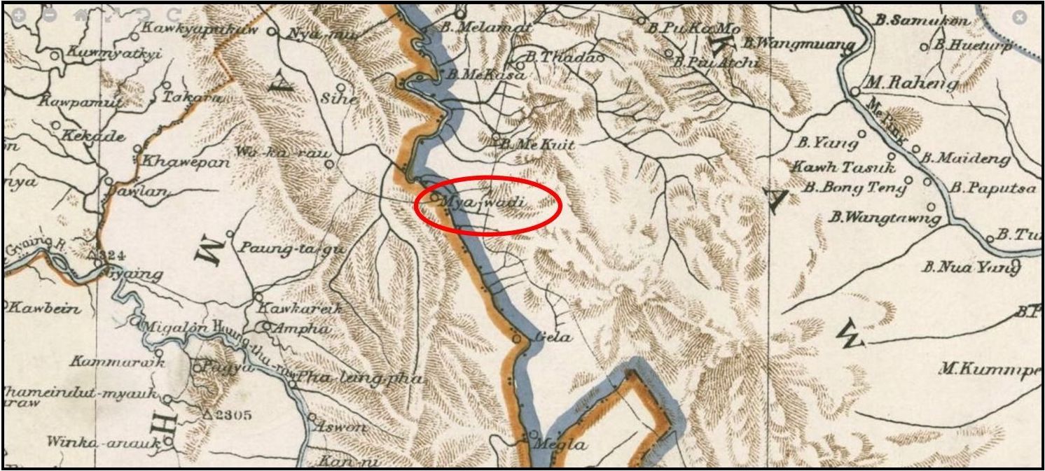
An airstrip at the border town, Mae Sot, had been built 1931~1932 by the Aerial Transport Company, as a entry point to Thailand from Burma, as a part of a planned Rangoon4-Hanoi5 (both Google Maps links) route:6
During 1938 the Aerial Transport Company, which since its inception had confined its air routes to the northeastern sector of the country, started plans for new services beyond . . . in their plans they added a third route to the west toward Burma. . . . The western route began in Phitsanulok7 and flew to Mae Sot on the Burmese border via Rahaeng8 (present day Tak) (both Google Maps links). [In mid May 1939] the company began the Phitsanulok-Mae Sot service . . . . Operations . . . for the fiscal year ending March 31, 1940, the company completed . . . 196 flights over the Phitsanulok-Mae Sot route (pp 99-100):9
15 March 1941
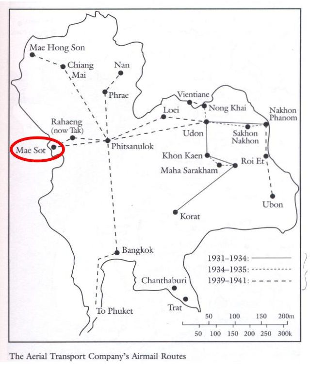
War Department, A Survey of Thailand (Siam), Civil Aviation provided a somewhat different version of the air transport network:10
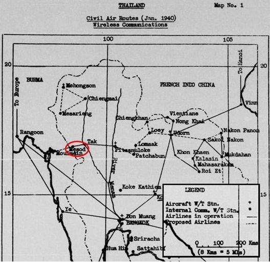
That government survey also noted that “The Phitsanulok-Tak-Mae Sot route of 200 km (124 mi) was flown twice weekly, using a Fairchild 24J and a DH [de Havilland] 80A Puss Moth”:11
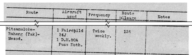
A USAAF report offered the additional information that the Phitsanulok-Tak-Mae Sot route of 200 km (124 mi) was flown twice weekly.12
Justification for putting Mae Sot in the air network included reducing its geographic isolation. A Survey of Thailand (Siam)13 report’s strategic view addressed Mae Sot’s isolation, key observation being “Only bridle paths are cut through the mountain passes”:14

Apparently the primitive living conditions at Mae Sot and the hardships of land travel to the border town did not discourage some (see Sivaram’s observations below), though travel by air was by far more desirable.
09 December 1941
A group of Brits from Bangkok escaping the Japanese invasion flew a chartered aircraft from Phitsanulok to Mae Sot from where they went on by land into Burma.15
December 1941
M Sivaram, an Indian journalist, fled to Mae Sot hoping to escape into British-held Burma to avoid the Japanese in their invasion of Thailand of late 1941. He recorded:16
[Mae Sot] may not be on the map. It is a mean little village on the banks of a shallow creek that forms the boundary between Thailand and Burma in the mountainous hinterland east of the Dawna Ranges. . . . [Mae Sot] is the frontier post on the Thai side, a desolate little spot on the fringes of the jungle, with two rows thatched huts along the main street and a few dilapidated buildings which house the government offices.
And it was isolated:
Going to Mae Sot, he recorded:17
A few hours journey by train to Sawangaloke, followed by a hectic bus ride, took us to the tiny town of Raheng on the edge of the jungles and mountains. . . . Raheng, on the east bank of the Maeping River, was considered those days as the last outpost of civilization in central Thailand. . . . The ferry was not available, so we waded across the [Mae Ping], and then the jungle enveloped us. . . . narrow, winding tracks through the dense forests and the perilous ascents and descents . . . waded through muddy streams and swamps without noticing the leeches . . . after a trek lasting three and a half days . . . Mae Sot . . . .
With all this, he found the border closed, forcing a return to Bangkok, but on leisurely terms, after he, an honored journalist, had displayed a Thai Home Defense Medal awarded him for his favorable coverage of the Franco-Thai War a year before.
For his return to Bangkok:18
. . . we hired a elephant to carry our luggage. It was an unexciting retreat and we did the trek by easy stages — five days to Raheng and four days by road and rail to Bangkok.
(Sivaram ended up staying within the eastern Axis military theatre to serve as Propaganda and Publicity Secretary in the Azad Hind government formed by Indian nationalist leader Subhas Chandra Bose).19
December 1941
IJA troops were similarly appalled at the primitive trail they traversed from Tak to Mae Sot:20
Many soldiers’ diaries complain of the toughness of this approach march through the jungle: “our hardships baffle description” is a typical statement, and it took four long days to reach Mae Sot.
19 December 1941
RAF Flt Off Peter Michael Bingham-Wallis flying 67 Squadron W8241 Buffalo flew out of Mergui Airfield21 (offsite link) (now Myeik) on three separate patrols to take aerial photos of (all Google Maps links):
- Chomphon: Na Noi22 or Na Nian Airfield (now long abandoned)
Ranong Airfield23
Victoria Point Airfield,24 Burma (now Kawthoung) - Prachuap Khiri Khan25
- Tavoy Airfield,26 Burma (now Dawei)
Mae Sot Airfield27
Mingaladon Airfield28 (at Rangoon, now Yangon)
Two Buffalos were flown by Sgt Charles Victor Bargh and Flt Lt David John Colin Pynkney as escorts. During their missions, they spotted three different trains carrying Japanese troops; however, they had been specifically ordered not to shoot anything.29
23 December 1941
Flt Sgt Martin H Huggard in RAF 60 Squadron Blenheim L4915, patrolled along the corridor:
- Chumphon
- Kamphaeng Phet30 (Google Maps link)
- Tak
- Mae Sot31
Jan-Apr 1942
The Thai Payap Army prepared to support the Imperial Japanese Army with numerous actions, including moving its 2nd Division to the Nakhon Sawan32 (Google Maps link) and Phitsanulok to protect the Mae Sot checkpoint border area.33
Early 1942
Grant and Tamayama noted:34
Until the IJA advanced across the Moei River separating Thailand and Burma, the Indian postmaster at Miyawadi35 (Google Maps link) in Burma, directly opposite Mae Sot, telephoned reports of aircraft using the Mae Sot airfield to the British command.
Both Stowe36 and Reynolds37 write of Thais assisting the IJA in cutting a road through from Rahaeng to Mae Sot. The latter provides more detail:38
Although experts had estimated that it would take five months to turn the 120-kilometer39 trail from Tak to the Burmese border into a usable motor road, the Thai and Japanese armies undertook a crash program to accomplish this in 50 days. The governor of Phitsanulok province and the mayor of Sukhothai received medals from the Japanese for their cooperation. Thai army liaison personnel assisted in various ways, and Thai students from the Bangkok Japanese Language School came to provide interpretng services.
02 January 1942
Time: 1230 hrs. Allied aircraft attacked Mae Sot District, killing two people.40
08 Jan 1942
AVG P-40s, led by Charlie Mott, assigned to attack the IJAAF at Mae Sot airfield, mistakenly passed over their target to instead attack the airfield at Tak, also occupied by the IJAAF, and where Mott was shot down.41
Lethbridge Herald, 09 Jan 1942, p 2, printed the AP article on the attack which quoted Allied sources mistakenly locating it in Mae Sot:
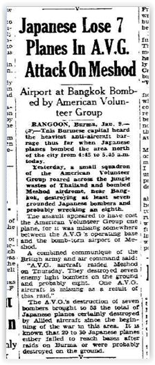 Japanese Lose 7 Planes In AVG Attack on Meshod
_____
Airport at Bangkok Bombed by American Volunteer Group
RANGOON, Burma, Jan 9-(AP) — This Burmese capital capital heard the heaviest anti-aircraft barrage thus far when Japanese planes bombed the area north of the city from 4:45 to 5:45 am today.
Yesterday, a small squadron of the American Volunteer Group roared across the jungle wastes of Thailand and bombed Meshod airdrome, near Bangkok, destroying at least seven grounded Japanese bombers and probably wrecking an eigthth.
The assault appeared to have cost the American Volunteer Group one plane, for it was missing somewhere between the AVG’s operating base and the bomb-torn airport of Meshod.
A combined communique of the British army and air command said:
“AVG aircraft raided Meshod on Thursday. They destroyed seven enemy light bombers on the ground and probably eight. One AVG aircraft is missing as a result of this raid.” . . .
. . . The AVG’s destruction of seven bombers brought to 53 the total of Japanese planes certainly destroyed by Allied aircraft since the beginning of the war in this area. It is known that 20 to 30 Japanese planes failed to reach bases after raids on Burma or were probably destroyed on the ground.
10 Jan 1942
RAF 67 Squadron Buffaloes strafed Japanese troops and destroyed two 31st Sentai Ki-30 light bombers at Mae Sot.42
13 January 1942
An RAF 67 Squadron Buffalo fighter flew low in patrolling Tak and Mae Sot Airfields.43
14 January 1942
Three RAF 67 Squadron Buffalo fighters attacked Mae Sot Airfield: one IJAAF plane was hit and exploded during takeoff.44
17 January 1942
RAF 67 Squadron “shot up targets” in Tak and Mae Sot, wounding two and killing two.45
19 January 1942
Time 1130 hrs. Four Flying Tiger P-40s attacked Mae Sot Airfield and shot down one IJAAF Ki-30 light bomber that was landing.46
20 January 1942
An overview of the period 20-22 January from The London Gazette:47
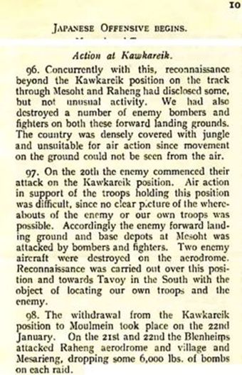
0500: The IJA ground attack out of Mae Sot into Burma began.48
Time 1115 hra: 113 Squadron Blenheims bombed Mae Sot, causing fires in three places, wounding four people, with two parked aircraft claimed destroyed. In dogfights, four IJAAF fighters and one Flying Tiger P-40 were downed.49
22 January 1942
Mae Sot is printed in green, indicating that the Japanese recognized it as the location of an existing airfield. Note the JUNGLE AREA called out separating Mae Sot from Tak — it was more a rugged mountainous area:50
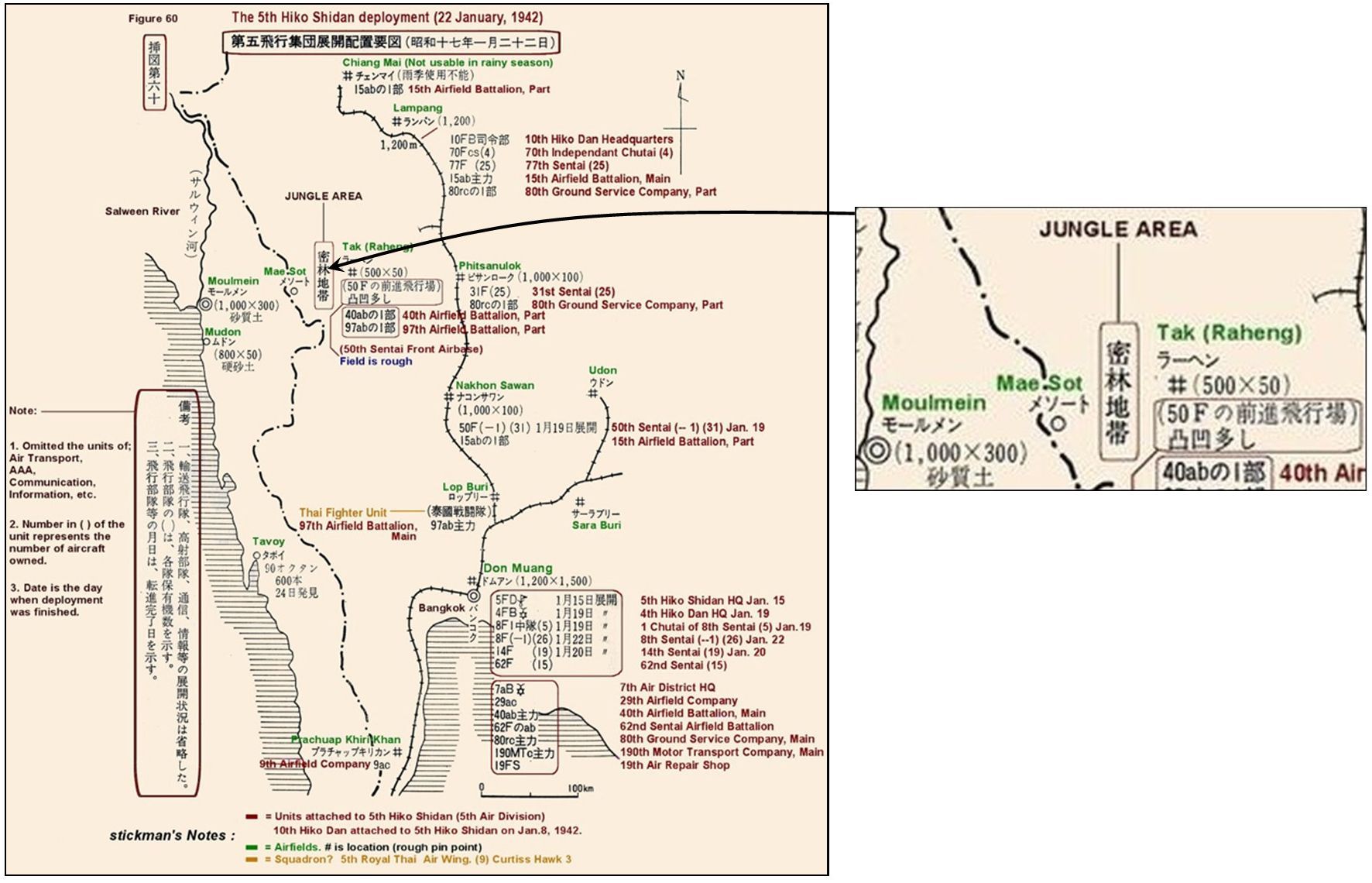
22 Jan 1942
Ammunition and fuel supplies in stock at Mae Sot:51
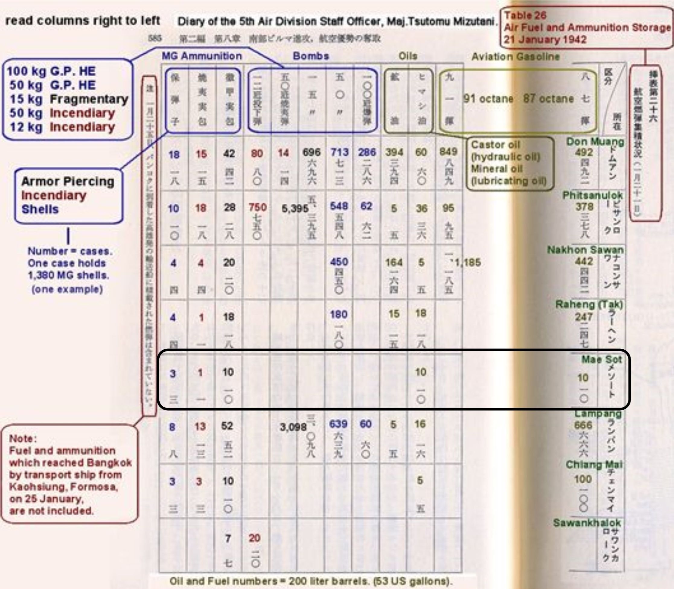
Transcript:
Ammunition:
-
-
- 3 cases of armor piercing
- 1 case of incendiary
- 10 cases of shells
-
Oils: 10 cases of lubricating
23 January 1942
Six RAF Blenheims dropped three tons of bombs on the Japanese military camp at Mat Sot.52
01 February 1942
An RAF 135 Squadron Hawker Hurricane patrolled Mae Sot and Tak.53
08 February 1942
An RAF 135 Squadron Hurricane photographed Tak and Mae Sot Airfields.54
15 February 1942
IJAAF Sentai had apparently moved on from Mae Sot (and Tak) after the IJA 33rd and 55th Divisions started their advance into Burma from Mae Sot on 20 January:55
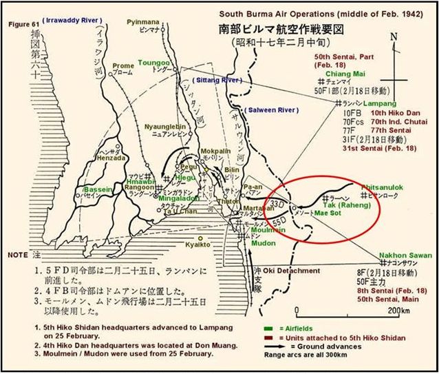
26 February 1942
An RAF Hurricane photography included Mae Sot.56
03 March 1942
The Mae Sot air facility appeared to have evolved into insignificance for IJAAF operations and is not even called out on this date:57
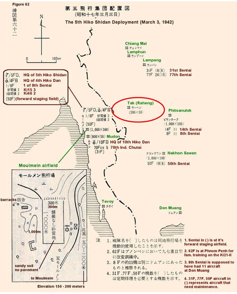 28 June 1942
Airport Directory South East Asia:58
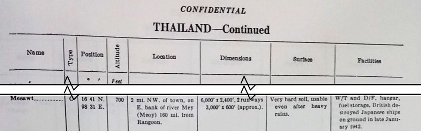
Transcript:
-
- Name: Mesawt
- Type: C [Civil airports (Private and Commercial) of reasonable size and having at least the more important facilities]
- Coordinates: 16 41 N, 98 31 E
- Altitude: 700
- Location: 2 mi NW of town, on E bank of river Mey (Meoy) [Moei] 160 mi from Rangoon.
- Dimensions: 6,000′ x 2,400′, 2 runways 3,000′ x 600′ (approx.).
- Surface: Very hard soil, usable even after heavy rains.
- Facilities: W/T [wireless transmitter] and D/F [direction finder], hangar, fuel storage, British destroyed Japanese ships on ground in late January 1942.
January 1943
The Rahaeng – Mae Sot — Moulmein Road, along which the 55th and 33rd Divisions had passed to Burma in early 1942, was inspected for use as a possible land supply route supplementing the Thai-Burma Railway; it was rejected because of conditions along the Rahaeng-Mae Sot section: washouts and landslides resulting from subsequent monsoon rains had not been repaired, plus tropical vegetation had quickly regrown to reclaim the road.59 It seems clear that the Mae Sot airfield itself had been abandoned after its use during the land invasion of Burma. One has to wonder how the Aerial Transport Company had built the airfield in 1931~1932 and then maintained it for the next nine or ten years until the IJAAF appropriated the facility.
01 February 1943
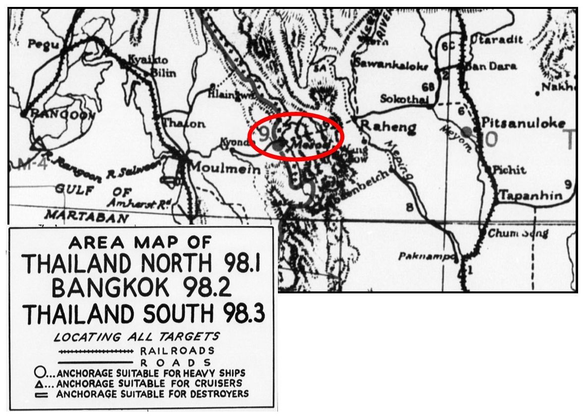
Nonetheless, the Allies continued to include Mae Sot on its list of air targets:60

and locate it on the Allies’ target map as No. 9:61
September 1943
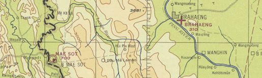
From World Aeronautical Chart (677) Gulf of Martaban dated Sep 1943 (with aeronautical information updated to Jan 1945). Note the dashed line connecting Tak (Brahaeng) with Mae Sot, indicating only a trail existed connecting the two [see Jan 1945 for information about aeronautical symbols]:62
19 November 1943
An RAF 684 Squadron Mosquito took aerial photos of Tak and Mae Sot Airfields.63
17 December 1943
An RAF 684 Squadron Mosquito photographed airfields, including Mae Sot and Tak.64
December 1943
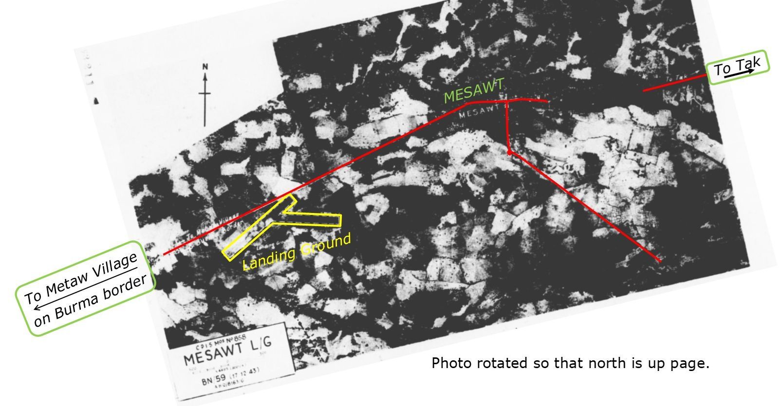
Markup of poor quality aerial photo reproduction dated 17 Dec 1943 and only distributed in April 1944’s Airfield Report No 21, unpaginated, with features annotated:65
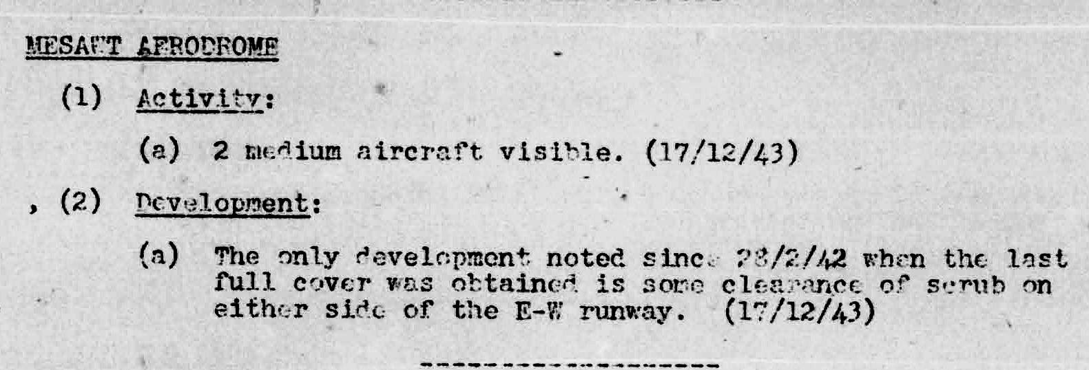
Mentioned under Thailand “Activity and Development” (the 28 Feb 1942 report was not available):66
January 1944
Airfield Report No 18 published this correction of Mae Sot’s capabilities:
Amendment No 2 Amendments to Thailand Aerodrome List. (The document being amended is not identified):67
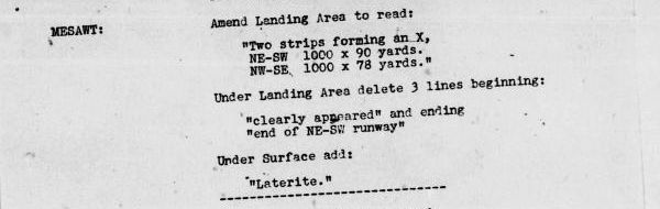
Transcript
MESAWT:
Amend Landing Area to read:
“Two strips forming an X,
NE-SW 1000 x 90 yards
NW-SE 1000 x 78 yards.”
Under Landing Area delete 3 lines beginning:
“clearly appeared” and ending
“end of NE-SW runway”
Under surface add:
“Laterite”
Report No. 18 added this summary sketch, called a “miniature”, for Mae Sot, which was one of seven new Thai miniatures on this date increasing the Thai count from four to eleven (in comparison, Burma airfield miniatures were well over 100):68
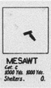
Transcript:
MESAWT
Cat [Category] C: (Liable to become unserviceable after rains)
1000 Yds 1000 Yds: each runway was 1000 yards
Shelters: 0 [none]
Note that the alignment of the runways is not consistent with other records.69
03 January 1944
A USAAF 21st Squadron F-5A patrolled northern Thailand, including Mae Sot.70
29 January 1944
An Allied aircraft photographed Tak and Mae Sot Airfields.71
28 March 1944
One of three RAF 684 Squadron Mosquitos photographed Thai airfields, including Mae Sot.72
April 1944
Airfield Report No 21 offers this airfield schedule for Mae Sot (Mesawt/Mesoht/Mesod):73
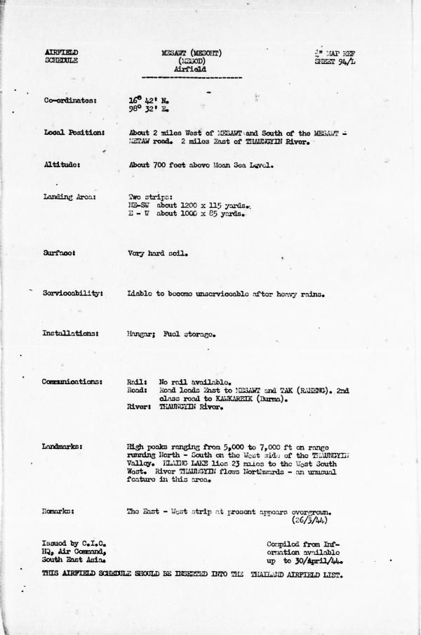
Transcript of relevant items:
Coordinates: N16°42 E98°32
Local Position: About 2 miles west of Mesawt and south of the Mesawt-Metaw road. 2 miles east of Thaungyin [Moei] River.
Altitude: About 700 feet above Mean Sea Level.
Landing Area: Two strips
. NE-SW about 1200 x 115 yards, E – W about 1000 x 85 yards
. Surface: Very hard soil.
Serviceability: Liable to become unserviceable after heavy rains.
Installations: Hangar; Fuel storage
Communications: Rail: No rail available.
. Road: Road leads east to Mesawt and Tak (Raheng).
. 2nd class road to Kawkareik (Burma).
. River: Thaungyin [Moei] River.
Landmarks: High peaks ranging from 5,000 to 7,000 ft on range running North-South on the west side of the Thaungyin Valley. Hlaing Lake lies 23 miles to the west-southwest. River Thaungyin flows northwards — an unusual feature in this area.
Remarks: The east-west strip at present appears overgrown (26/3/44)
Note that while the report above remarks that the east-west strip was overgrown, no mention was made of the longer NE-SW strip. But a potential explanation is offered:74

Transcript:
It is interesting to note that the meagre line of landing grounds in close proximity to the Burmese border from Mehongson to Mesawt, including Kun Yom [Khun Yuam] and Mesariang, have not to date been developed. In view of their difficult line of communications it is unlikely however, that they would be employed for any purposed other than emergency use so that some form of maintenance work is likely to be the limit of their attention.
Record of Airfield Activity and Development: Thailand.75

Transcript of relevant text:
Activity: Two aircraft were observed on this site on 28/3/44. They are believed to be unserviceable and are in the same positions as observed on 17/12/43. (28/3/44)
July 1944
Provisional Airfield List, Southeast Asia, Enemy Airfield Information, Report No 3 (Washington: Office of Assistant Chief of Air Staff, 25 Jul 1944):76
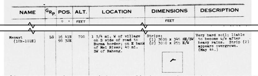
Special Report No LA1
List of Airfields with Unserviceable Aircraft, Dummies, and/or Decoys State at 1/July/44:77

Transcript:
[Airfield:] Mesawt
[Sortie:] RN/242
[Print:] 3114
[Details:] 2 u/s [unserviceable] a/c [aircraft] (Nos 1 & 2) without engines. Unmoved since Dec/1943
Special Report No LA2
List of Airfields with Unserviceable Aircraft, Dummies, and/or Decoys State at 1/Aug/44:78

Transcript:
Airfield: Mesawt
Details: – do – (ie, “No cover received since July 1st”)
Special Report No LA3
List of Airfields with Unserviceable Aircraft, Dummies, and/or Decoys State at 1/Sep/44:79

Transcript:
[Airfield:] Mesawt L/O [landing ground]
[Sortie:] Rn/242
[Print:] 3114
[Details:] – do – (ie, “No cover received since Aug.1”)
Special Report No LA4
List of Airfields with Unserviceable Aircraft, Dummies, and/or Decoys State at 1/Oct/44:80

Transcript: [unchanged from previous month]:
[Airfield:] Mesawt L/O [landing ground]
[Sortie:] Rn/242
[Print:] 3114
[Details:] – do – (ie, “No cover received since Aug.1”)
November 1944
Airfield Report No 28 presented an updated airfield schedule for Mae Sot, but with no substantive changes.81
15 November 1944
Road and Railroad Communications (Joint Intelligence Collection Agency, China-Burma-India, South East Asia (JICA: CBI: SEA) )
SIAM-ROADS AND RAILROADS (dated “15-31 Oct 1944”; but data page dated 15 Nov 44):82

Transcript:
SIAM – BURMA. A report has been received from Chinese sources indicating that:
The road TAK-MESORT-MOULMEIN is being used by the Japs for the transport of troops and supplies into BURMA.
23 November 1944
A USAAF 35th Squadron F-5E photographed airfields in northern Thailand, including Mae Sot.83
Road Railroad Communications Report (Joint Intelligence Collection Agency, China-Burma-India, South East Asia (JICA: CBI: SEA) )
SIAM – ROADS AND RAILROADS (30 Nov 1944):84
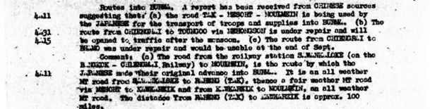
Transcript of relevant text:
Routes into Burma. A report has been received from CHINESE sources suggesting that:
(a) the road TAK-MESOHT-MOULMEIN is being used by the JAPANESE for the transport of troops and supplies into BURMA. . . .
Comment: (a) The road from the railway station SAWANKALOKE (on the BANGKOK-CHIANGMAI Railway) to MOULMEIN, is the route by which the JAPANESE made their original advance into BURMA. It is an all weather MT (motor transport) road from SAWANKALOKE to RAHENG (TAK), thence a fair weather MT road via MESOHT to KAWKAREIK . . . .
Special Report No. LA5, p 3 (18/Nov/44):85

Transcript of relevant text:
MESAWT L/G [landing ground]. There has been no cover since Mar/44 when there were two small S/E [single engine] aircraft probably unserviceable which have been in the same positions since Dec/42.
12 December 1944
One RAF 27 Squadron Bristol Beaufighter patrolled the Tak-Mae Sot Road [part future Thai Route 12].86
14 December 1944
A USAAF 40th Squadron F-5 photographed airfields in northern Thailand, including Mae Sot and Tak.87
January 1945
Siam (Thailand): List of Airfields and Seaplane Stations:88
Mae Sot: Introductory paragraph:

Schedule for Mae Sot was reissued, with minor changes:
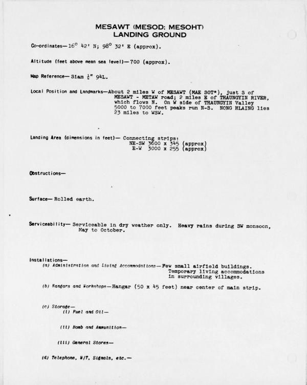
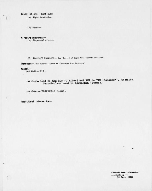
Transcript of relevant items:
Coordinates: N16°42 E98°32 (approx).
Altitude (feet above Mean Sea Level): 700 (approx).
Map Reference: Siam ¼” 94L
Local Position and Landmarks: About 2 miles W of Mesawt (MAE SOT*), just south of MESAWT-METAW road; 2 miles E of Thaungyin [Moei] River, which flows N. On W side of THAUNGYIN Valley, 5000 to 7000 feet peaks run N-S. NONG HLAING lies 23 miles to WSW.
Landing Area (dimensions in feet):
. Connecting strips
. NE-SW about 3600 x 345 (approx)
. E – W about 3000 x 255 (approx)
Obstructions: — [blank]
Surface: Rolled earth.
Serviceability: Serviceable in dry weather only. Heavy rains during SW monsoon, May to October.
Installations:
-
-
- Administration and Living Accommodations-Few small airfield buildings. Temporary living accommodations in surrounding villages.
- Hangars and Workshops-Hangar (50 x 45 feet) near center of main strip.
- Storage–
- Fuel and Oil-
- Bomb and Ammunition
- General Stores
- Telephone, W/T, Signals, etc-
- Night Landing–
- Water–
-
Aircraft Dispersals
-
-
- Dispersal Areas–
- Aircraft Shelters . . .
-
Access-
-
-
- Rail-Nil
- Road-Road to MAE SOT (2 miles and ENE tot TAK (RAHAENG*), 42 miles. Second-class road to KAWKAREIK
- Water-THAUNGYIN RIVER
-
Additional Information-[blank]
Airfield Report No 30:
(Introductory section) A survey of present and future trends in Japanese airfield development. . . .
In Siam:89
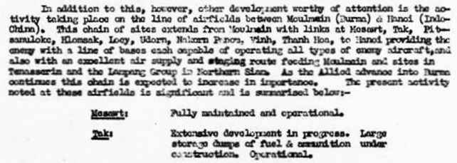
Transcript:
. . . other development worthy of attention is the activity taking place on the line of airfields between Moulmein (Burma) & Hanoi (Indo China) [following links are to Google Maps] . . . .
Moulmein90
Mae Sot91
Tak92
Phitsanuloke93
Lomsak94
Loei95
Udorn96
Nakhon Phanom97
Vinh98
Thanh Hoa99
Hanoi (Gia Lam)100
And tracked on this map:101
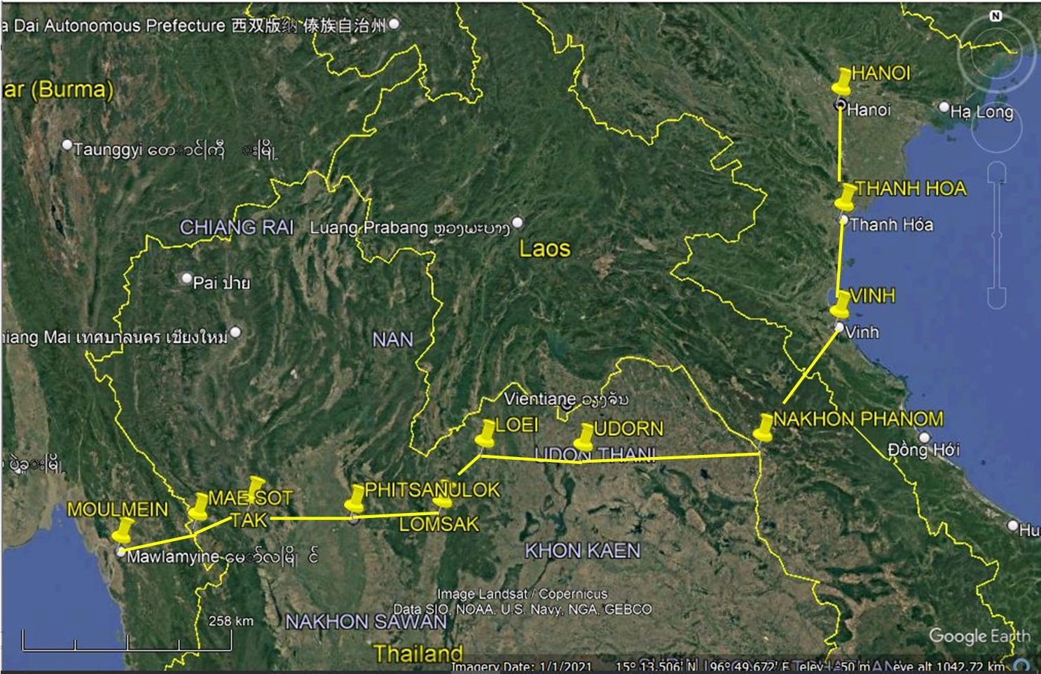
. . . providing the enemy with a line of bases each capable of operating all types of enemy aircraft, and also with an excellent air supply and staging route feeding Moulmein and sites in Tenasserim and the Lampang Group in Northern Siam. As the Allied advance into Burma continues this chain is expected to increase in importance. The present activity noted at these airfields is significant and is summarized below:
Mesawt: Fully maintained and operational.
Tak: Extensive development in progress. Large storage dumps of fuel & ammunition under construction. Operational.
Jan 1945
From World Aeronautical Chart (677) Gulf of Martaban Sep 1943 (with aeronautical information updated to Jan 1945). Tak / Rahaeng appears as “Brahaeng”. The small square at Mae Sot indicates a small city of size 5,000 to 25,000 is the symbol for a city of size 25,000 to 100,000. The circle indicates a military field; the significance of the coloring of the second quadrant of the circle is not clear:62
01-15 Jan 1945
Transportation Report – Road, Railroad, and Inland Waterways (Joint Intelligence Collection Agency, China-Burma-India, South East Asia (JICA: CBI: SEA) )
SIAM Appendix “A: Siam – Roads & Railroads, p 24:102
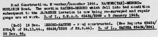
Transcript:
Road Construction, November/December 1944. RAHENG (TAK)-MAE SOT-MOULMEIN Road. The section RAHENG-MAE SOT which fall into bad condition subsequent to the JAPANESE invasion is now being re-surveyed and repair gangs are at work. D of I, SEAC 65434/2999-5 January 1945.
(B-O) 19 Dec. MAE SOT-RAHENG-road constructed. (see Reports 65434/2754/5 of 24.11.44, 66434/2225 of 26.8.44). D of I, SACSEA 65434/2941 29 Dec 44.
11 January 1945
A USAAF 40th Squadron F-5 photographed the road connecting Uttaradit and Mudon, Burma, which probably included covering Mae Sot.103
15-31 January 1945
Transportation Report: Road, Railroad, and Inland Waterways: (Joint Intelligence Collection Agency, China-Burma-India, South East Asia (JICA: CBI: SEA)104
SIAM

Transcript:
4A11 – RAHENG (TAK) 16°52/99°07 to MESORD (MESOHT) 16°39/98°32 to MOULMEIN 97°57/16°28 16°23/95°15
REFERENCE. (A-1). A monthly ISTD summary report describing the rds of SIAM. RAHENG to MESOHD. Appendix (Interrogation of two SWISS nationsals on SIAM). . . .
26 February 1945
A USAAF 40th Squadron F-5 phtographed airfields in northern Thailand, including Mae Sot.105
24 March 1945
An Allied aircraft attack on Mae Sot Airfield destroyed one single-engine aircraft.106
May 1945
Airfield Report No 34
Record of Airfield Activity and Development
SIAM107

Transcript:
MESAWT Landing Ground:
Development: In an attack on the landing ground on 11th May by Mosquitoes, when two crashed enemy aircraft were attacked, a fire was started in a hangarette. This is the first report of hangarette construction at this landing ground. (11th May 1945)
Serviceability: The landing ground is serviceable.
Special Interpretation Report No LA 11
Monthly report on Unserviceable, Dummy, and Decoy Aircraft seen on photographs of Airfields, Landing Grounds, and Seaplane Bases:108

11 May 1945
Allied aircraft photographed part of the Northern Railway Line and various airfields in northern Thailand including Mae Sot.109
24 June 1945
Crew on an RAF 357 Squadron Dakota, returning from a flight to parachute supplies to a Free Thai outpost, passed over Mae Sot Airfield and saw a Japanese twin-engine aircraft parked there.110
15 Jul-01 Aug 1945
Transportation Report, Road, Railroads, and Inland Waterways (Joint Intelligence Collection Agency, China-Burma-India, South East Asia (JICA: CBI: SEA)
Section II Roads – Siam:111

Transcript:
RAHENG (TAK) 16°52/99°07 to MAE SOT 16°39/98°32 to KYONDO 16°36/98°03
6July45. B-3. The JAPANESE are using conscripted labor on a large scale to repair the rd from RAHENG -MAE SOT via MERALES 00 3456 . . . .
_______
December 1948
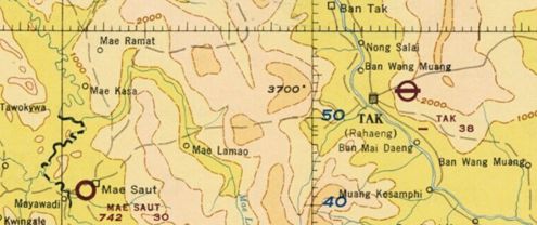
World Aeronautical Chart (677) Gulf of Martaban dated Dec 1948 shows the runway at Mae Sot:112
1953-4
Mae Sot airfield:113
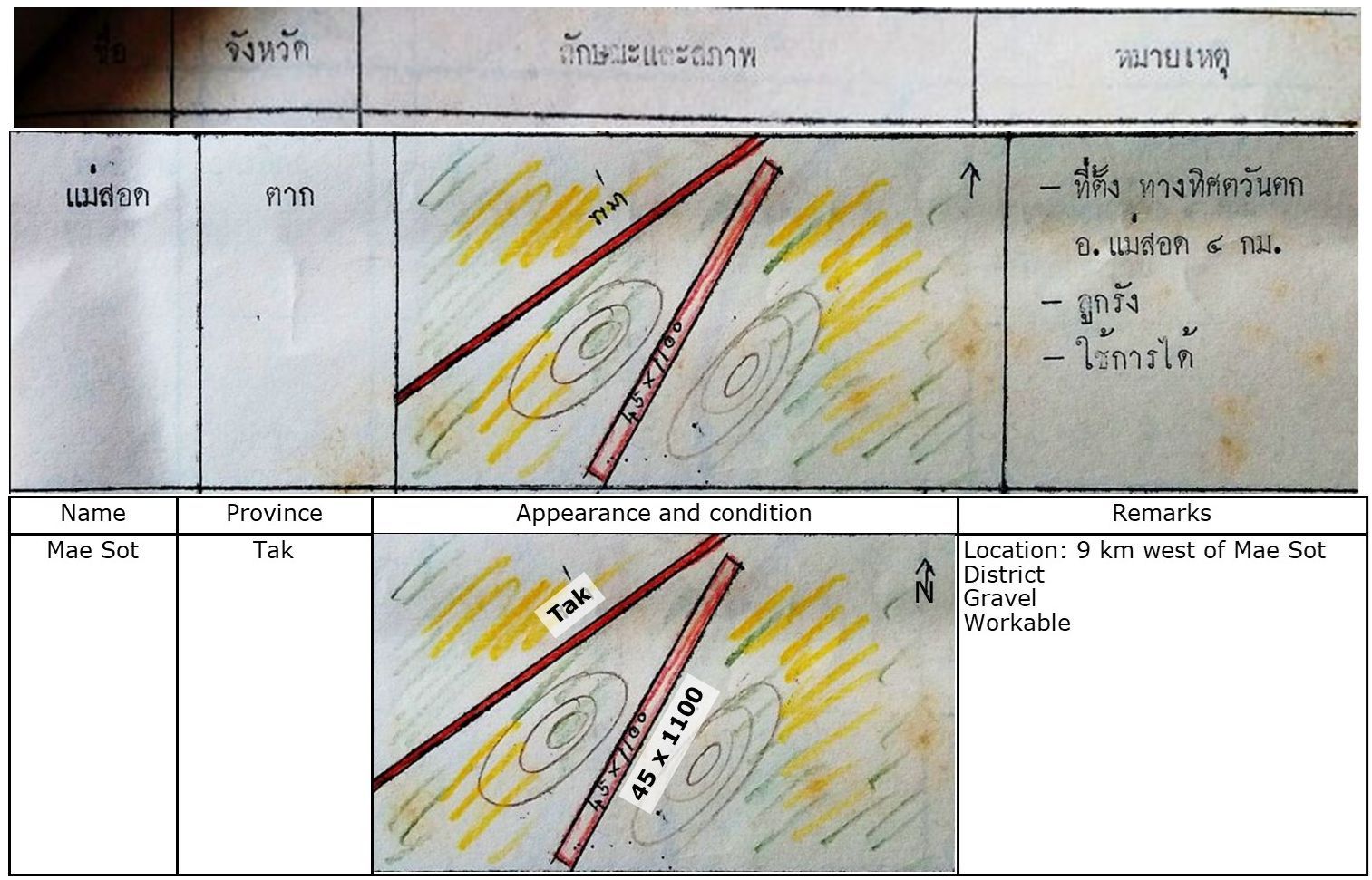
The airstrip as drawn is on heading 03/21, while the road adjacent is on a heading of about 05/23 Neither figure matches what is on the ground on Google Earth (GE). However, the difference in bearings / headings is consistent with GE. Note that the past and future E-W runway was not included in the sketch.
01 Feb 1971
Thai Air Facility Data Pamphlet:114
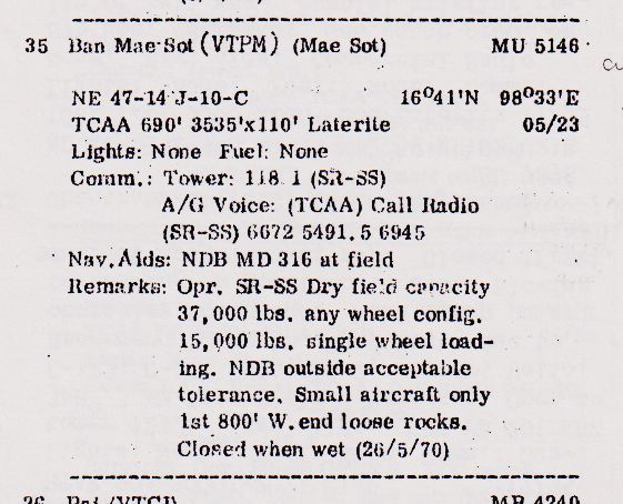
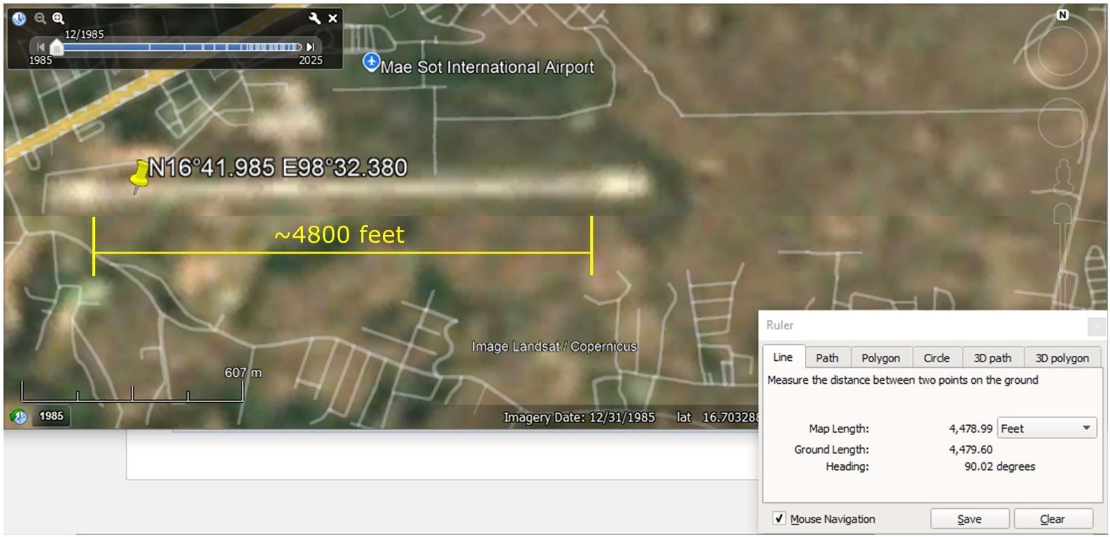
The original configuration of runways as variously described above, 05/23 and 09/27, was replaced some time between 01 Feb 1971 and June 1983 with a single runway with heading 09/27.
????~1983
Possible location of a configuration of runways at Mae Sot prior to current runway (letters locate details which follow):115
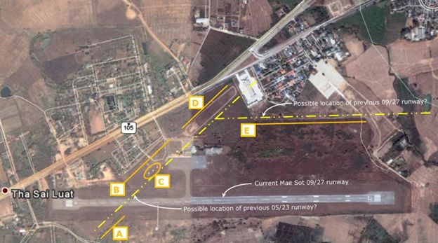
Comment: the location of the previous runway is not clearly discernable; however, there are a number of indicators for that location, particularly for the 05/23 runway (coordinates for estimated location of intersection of runways: N16°42.21 E98°32.68):
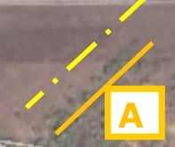
05/23 Runway
A. alignment of perimeter of undergrowth
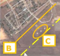
05/23 Runway
B: alignment of adjacent streets
C: alignment of unknown feature
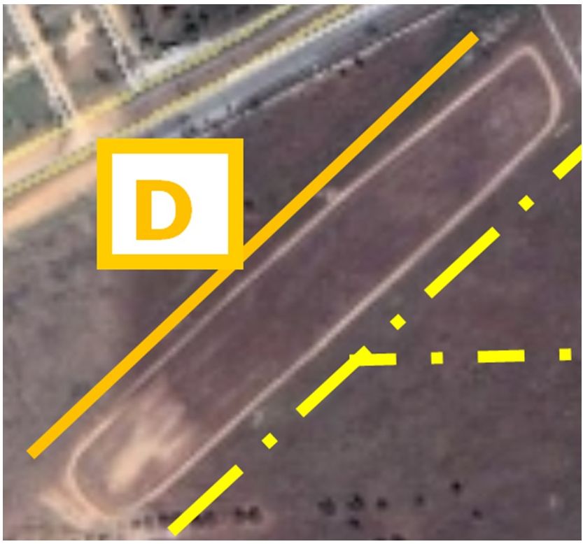
05/23 Runway
D: approximate alignment of unknown feature.
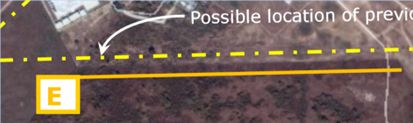
09/27 Runway
E: approximate alignment of undergrowth perimeter
1983
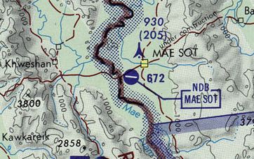
ONC (Operational Navigation Chart) J-10 revised to June 1983116
1985
Google Earth view showing runway approximate length of 4800 feet:117
2025
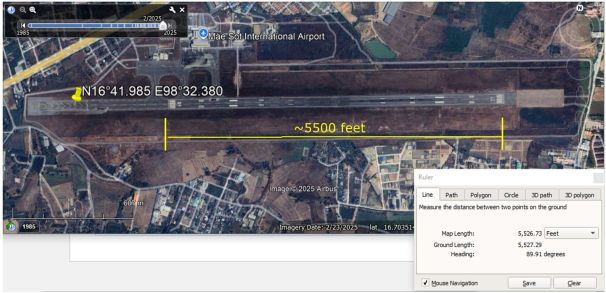
Google Earth view showing runway approximate length of 5500 feet, with westerly end displaced about 1800 feet to the east:117
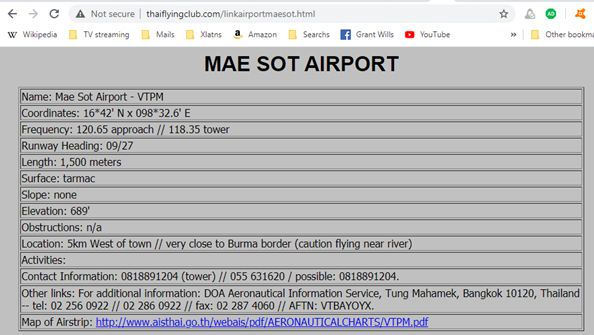
Thai Flying Club information: date (current):118
Mae Sot Airport is currently active with a daily single commercial flight connecting with Bangkok.119
| First published on Internet | ||
Last Updated on 16 September 2026
- Mae Sot Airport: N16°41.985 E98°32.380; my ref: \02370 Mae Sot\_Mae Sot Airfield.doc[↩]
- Google Earth extract annotated by author using LibreOffice Draw[↩]
- University of Wisconsin Madison: India and Adjacent Countries: Rangoon (offsite link); my ref: \02370 Tak (Rahaeng)\Old aerials markup.pub, sht 19; \02370 Mae Sot\16,096 094 Rangoon-agdm_19376_full-1907 pt anno.jpg; annotation by author using Microsoft Publisher.[↩]
- Rangoon: N16°54.43 E96°07.98[↩]
- Hanoi: N21°02.46 E05°53.16[↩]
- Young, EM, Aerial Nationalism (Washington: Smithsonian, 1995), p 84[↩]
- Phitsanulok: N16°47.01 E100°16.65[↩]
- Rahaeng: N16°52.65 E99°08.76[↩]
- ibid, p xi; my ref: \02370 Mae Sot\_Mae Sot Airfield.docx (Word markup[↩]
- My ref: \03400 USFE Cmd Documentation\USAF Archives\_TOPICS\Tak\400100 A2874 1467 MHS-CNX-MS.jpg in \03400 USFE Cmd Documentation\USAF Archives\_TOPICS\Tak\Maps.pub, sht 2; my ref: \03400 USFE Cmd Documentation\USAF Archives\_TOPICS\Mae Sot\400100 A2874 1467 MHS-CNX-MS.jpg[↩]
- My ref: \03400 USFE Cmd Documentation\USAF Archives\USAF Reel B1750 p 1748; my ref: \02370 Other locations\02370 Mae Sot\Old runway location.pub, sht 13[↩]
- My ref: \03400 USFE Cmd Documentation\USAF Archives\_TOPICS\_GENERAL\410000 USAF A2874 Survey of TH\USAF A2874 p1394 Thai Air Transpt Mar 41.jpg (Survey p 28) [↩]
- (Washington: War Department, 15 March 1941), p 2; my ref: \03400 USFE Cmd Documentation\US Archives\USAF Reel A2874 p1364[↩]
- My ref: \2370 Mae Sot\410100 A2874 p1368 MS isolation.jpg[↩]
- Christopher Shores, Brian Cull, Yasuho Izawa, Bloody Shambles, Vol 1 (London: Grub Street, 1992), p 97[↩]
- M Sivaram, The Road to Delhi (Rutland: Tuttle, 1967), p 55[↩]
- ibid, p 57[↩]
- ibid, p 62[↩]
- Goodreads (offsite link) [↩]
- Ian Lyall Grant and Kazuo Tamayama, Burma 1942: The Japanese Invasion (Chichester: Zampi, 1999), p 61[↩]
- Mergui Airfield: N12°26.82 E98°37.28[↩]
- Na Noi: N10°30.32 E99°05.31[↩]
- Ranong Airfield: N09°46.65 E98°35.13[↩]
- Victoria Point Airfield: N10°03 E98°32.30[↩]
- Prachuap Khiri Khan Airfield: N11°47.30 E99°48.27[↩]
- Tavoy Airfield: N14°05.89 E98°12.38[↩]
- Mae Sot Airfield: N16°41.985 E98°32.380[↩]
- Mingaladon Airfield: N16°54.43 E96°07.98[↩]
- Shores & Cull 1998: 240 & Thomas 1999: 27, 29 per ประว้ติกองท้พอากาส ในสงครามมหาเอเชียบูรพา ระหว่าง พ.ศ.-๒๔๘๔-๒๔๘๘ (นครราชสีมา: สมบูรณ์การพิมพ์, พ.ศ.๒๕๖๔) [History of the Royal Thai Air Force during the Great East Asia War, 1941-1945 (Nakhon Ratchasima: Somboon Printing, 2021)] translated from the Thai and hereafter, “RTAF History“, RTAF History], p 63[↩]
- Kamphaeng Phet: N16°28.30 E99°31.80[↩]
- Thomas 1999: 29 per RTAF History, p 63[↩]
- Nakhon Sawan: N15°40.35 E100°08.17[↩]
- RTAF History, p 66[↩]
- Ian Lyall Grant and Kazuo Tamayama, Burma 1942: The Japanese Invasion (Chichester: Zampi, 1999), p 63) [↩]
- Miyawadi: N16°41.09 E98°30.37[↩]
- Judith A Stowe, Siam becomes Thailand (Honolulu: University of Hawaii Press, 1991[↩]
- E Bruce Reynolds, Thailand and Japan’s Southern Advance 1940-1945 (New York: St Martin’s Press, 1994[↩]
- Reynolds, ibid, p 115[↩]
- Per travelmath.com, the distance today from the current Tak Airport to Mae Sot is ~85 km; presumably modern highway engineering and construction techniques have reduced the distance from ~120 km. The road has several stretches of 8% grade (and some perhaps greater); several adjacent slopes have earth anchors installed; even more have provided for piping to prevent water pressure from building up behind slopes; as we traveled the present day road, we saw several landslides having intruded on the roadway from upside slopes and two sections where lanes had fallen away on downside slopes.[↩]
- RTAF History, p 70[↩]
- Shores, etal, p 254; RTAF History, p 71[↩]
- Shores, etal, p 255; Grant & Tamayama, ibid, p 63, RTAF History, p 71[↩]
- RTAF History, p 73[↩]
- Shores, etal, 266 per RTAF History, p 73[↩]
- Shores, etal, p 257, RTAF History, p 74[↩]
- RTAF History, p 74[↩]
- The London Gazette, March 11th 1948 (Second Supplement), page: 10 (offsite link); my ref: \02370 Mae Sot\Mae Sot Fold3\Page 10.jpg[↩]
- Grant & Tamayama, ibid, p 64; Young, p 186[↩]
- Shores, etal, p 260; Ford 1991: 183-184; Hammel 1998: 14; Young 1995: 186; RTAF History, p 75[↩]
- Nanpo shinko rikugun koku sakusen (Japan Defense Agency, 1970); my refs: \03302 034 Senshi Sosho vol 34 (IJAAF drive)\MAPS, markups fm Warbirds\SS34 p 583 item 2 pt.jpg; and \02370 Mae Sot\Mae Sot Warbird blog.pub sht 9; (Rahaeng)\Tak 22 Jan 1941 IJA positns.jpg[↩]
- Senshi Sosho 34 pp 584-585; my refs: \03302 034\Senshi Sosho vol 34 (IJAAF drive) \573-585\584-585.jpg; markup: \03302 034 Senshi Sosho vol 34 (IJAAF drive)\MAPS, markups fm Warbirds\aviationfuelandammunitiqm1.jpg; and \02370 Mae Sot\Mae Sot Warbird blog.pub sht 6) [↩]
- ACSEA-BO; Ford 1991: 186; RAF 1942: 2; Shores & Cull 1998: 263, per RTAF History, p 75[↩]
- Shores & Cull 2000: 256; Thomas 1999: 30, per RTAF History, p 78[↩]
- Thomas 1999: 30, per RTAF History, p 80[↩]
- My refs: \03302 034 Senshi Sosho vol 34 (IJAAF drive)\MAPS, markups fm Warbirds\SS34 p 597 item 3.jpg; my refs: \02370 Mae Sot\Mae Sot Warbird blog.pub sht 9 and \02370 Tak (Rahaeng)\Tak 15 Feb 1941 IJA positns.jpg[↩]
- Thomas 1999: 31, per RTAF History, p 83[↩]
- My ref: \03302 034 Senshi Sosho vol 34 (IJAAF drive)\MAPS, markups fm Warbirds\SS34 p 607, item 4.jpg; \02370 Mae Sot\Mae Sot Warbird blog.pub sht 10; and 02370 Tak (Rahaeng)\Tak 03 Mar 1942 IJA positns.jpg[↩]
- South East Asia: Airport Directory (Washington: USAAF, 28 Jun 1942), p 9; my ref: \03400 USFE Cmd Documentation\_Airfields List (Sak)\1942 Originals\19420628-09.jpg: \1942 origs meld.pub sht 1[↩]
- Sensei Sosho (the official Japanese military history of World War II, Imphal Operation, vol 15, pp 141-142; my ref: \03302 015 Senshi Sosho vol 15 (Imphal op)\SS15 JOSH raw xlatn\SS15 p140.jpg; \03302 015 Senshi Sosho vol 15 (Imphal op)\SS15 JOSH raw xlatn\SS15 Hak xlatn 111608.rtf[↩]
- NARA M1653. WWII Japanese air target analyses, objectives, and aerial photographs, 1942-45, from the records of the U.S. Strategic Bombing Survey, SECTION 7. JAPANESE TARGET INTELLIGENCE, Air Objective Folder Thailand, p T-6; my ref: \03200 Sakpinit P books\Targets\Target list Thailand Feb 43\1125.jpg[↩]
- ibid, U.S. Strategic Bombing Survey, SECTION 7. JAPANESE TARGET INTELLIGENCE, p T-4; my ref: ibid\Target list Thailand Feb 43\1122-3.jpg[↩]
- source: McMaster Collection, Canada Chart (677) Gulf of Martaban (offsite link); my ref: (1)\bPROJECT\_MAPS\THAILAND Maps\COLLECTN McMASTER\677-macrepo_76844.jpg;(2)\02370 Other locations\02370 Tak (Rahaeng)\677-macrepo_76844 pt.jpg[↩][↩]
- RTAF History, p 155[↩]
- RTAF History, p 159[↩]
- my ref: \03400 USFE Cmd Documentation\USAF Archives\_TOPICS\Mae Sot\431200 USAF A8055 p0647 Mae Sot aerial Dec 43.jpg; \02370 Mae Sot\Mae Sot Warbird blog.pub, sht 3: Mae Sot Landing Ground markup.jpg[↩]
- My ref: \03400 USFE Cmd Documentation\USAF Archives\_TOPICS\Mae Sot\431200 USAF A8055 p0380 Mae Sot activity Dec 43.jpg[↩]
- My ref: \03400 USFE Cmd Documentation\USAF Archives\_TOPICS\Mae Sot\440100 USAF A8055 p0476 MHS, Mae Sariang, Mae Sot AFs status Jan 44 pt.jpg[↩]
- My ref: \03400 USFE Cmd Documentation\USAF Archives\_TOPICS\Mae Sot\440100 USAF A8055 p0422 Thai miniatures Mae Sot Jan 44.jpg[↩]
- Airfield Report No 18, unpaginated; my ref: 440100 USAF A8055 p0422 Thai miniatures Mae Sot Jan 44.jpg[↩]
- 21 PRS (21st Photographic Reconnaissance Squadron–Flight Intelligence Reports) per RTAF History, p 168[↩]
- RTAF History, p 174[↩]
- RTAF History, p 188[↩]
- Airfield Report No 21, CIO HQ Air CSEA, Apr 1944), portion unpaginated; my ref: \03400 USFE Cmd Documentation\USAF Archives\REEL A8055\0672 Mae Sot AF descrip Apr 44.jpg[↩]
- Airfield Report No 21 (CIO HQ Air CSEA, Apr 1944), p 5; my ref:\02370 Mae Sot\a440400 USAF A8055 p0688 Thai AF devmt CNX LPG Koh UTT Kra Apr 44 (pt).jpg[↩]
- My ref: \03400 USFE Cmd Documentation\USAF Archives\_TOPICS\Mae Sot\440400 USAF A8055 p0714 Mae Sot, Phre AFs status Apr 44.jpg[↩]
- My ref:\03400 USFE Cmd Documentation\USAF Archives\_TOPICS\Mae Sot\440700 USAF A1284 p1413 Mae Sariang ELG, Mae Sot LG descrip Jul 44.jpg; and \02370 Mae Sot\Old runway location.pub Sht 9.[↩]
- My ref: \03400 USFE Cmd Documentation\USAF Archives\_TOPICS\Mae Sot\440700 USAF A8056 p0596 Mae Sot AF Jul 44.jpg[↩]
- \03400 USFE Cmd Documentation\USAF Archives\_TOPICS\Mae Sot\440800 USAF A8056 p0594 Mae Sot AF Aug 44.jpg[↩]
- My ref: \03400 USFE Cmd Documentation\USAF Archives\_TOPICS\Mae Sot\440900 USAF A8056 p0592 Mae Sot AF Sep 44.jpg[↩]
- My ref: \03400 USFE Cmd Documentation\USAF Archives\_TOPICS\Mae Sot\441000 USAF A8056 p0590 CNX, Mae Sot AF Oct 44.jpg[↩]
- CIO HQ Air CSEA, Nov 1944; my ref: \03400 USFE Cmd Documentation\USAF Archives\_TOPICS\Mae Sot\441100 USAF A8055 p1079 Mae Sot AF descrip Nov 44.jpg[↩]
- My ref: \03400 USFE Cmd Documentation\USAF Archives\_TOPICS\Mae Sot\441008 USAF A8044 p0138 CNX-MHS-Toungoo, Tak-MaeSot-MM Rds 08 Oct 44.jpg[↩]
- 35 Photographic Reconnaissance Squadron, per RTAF History, p 259[↩]
- My ref: \03400 USFE Cmd Documentation\USAF Archives\_TOPICS\Mae Sot\441031 USAF A8044 p0188 CNR, CNX, Mae Sot Rds end Oct 44.jpg[↩]
- My refs: \03400 USFE Cmd Documentation\USAF Archives\_TOPICS\Mae Sot\441031 USAF A8044 p0188 CNR, CNX, Mae Sot Rds end Oct 44.jpg and \03400 USFE Cmd Documentation\USAF Archives\_TOPICS\Mae Sot\441100 USAF A8056 p0588 Mae Sot status Nov 44.jpg[↩]
- RTAF History, p 173[↩]
- RTAF History, p 178[↩]
- My ref: \03400 USFE Cmd Documentation\USAF Archives\_TOPICS\Mae Sot\441200 USAF A1285, 6, 7, p1246 Mae Sot LG descrip Dec 44.jpg[↩]
- My ref: \03400 USFE Cmd Documentation\USAF Archives\_TOPICS\Tak\450100 USAF A8055 p1242 Thai AF devmt CNX, LPG, MM, Tak desc Jan 45.jpg[↩]
- Moulmein: N16°26.68 E97°39.64[↩]
- Mae Sot: N16°42.00 E98°32.66[↩]
- Tak: N16°52.65 E99°08.76[↩]
- Phitsanuloke: N16°47.01 E100°16.65[↩]
- Lomsak: N16°49.40 E101°15.07[↩]
- Loei: N17°26.30 E101°43.30[↩]
- Udorn: N17°22.70 E102°48.00[↩]
- Nakhon Phanom: N17°24.77 E104°46.51″[↩]
- Vinh: N18°44.20 E105°40.25[↩]
- Thanh Hoa: N19°54.07 E105°28.07[↩]
- Hanoi (Gia Lam): N21°02.46 E05°53.16[↩]
- Extract from Google Earth, annotated by author using Microsoft Publisher.[↩]
- My ref: \03400 USFE Cmd Documentation\USAF Archives\_TOPICS\Tak\450100 USAF A8044 p0476 Tak-Moulmein Rd repair, CNR-Kengtung Rd Jan 45.jpg[↩]
- RTAF History, p 292[↩]
- but data dated “15 Feb 45” and information for the item mentioning Mae Sot was dated 01 Jan 45[↩]
- RTAF History, p 316[↩]
- RTAF History, p 340[↩]
- My ref: \03400 USFE Cmd Documentation\USAF Archives\_TOPICS\Mae Sot\450400 USAF A8056 p0302 Kohga, LPG, Memoh, MaeSot, Phre AFs activity Apr 45.jpg[↩]
- My ref: \03400 USFE Cmd Documentation\USAF Archives\_TOPICS\Mae Sot\450513 USAF A8056 p0531 Mae Sot, Phre AFs status Apr 45.jpg[↩]
- RTAF History, p 370[↩]
- RTAF History, p 394[↩]
- \03400 USFE Cmd Documentation\USAF Archives\_TOPICS\Tak\450715 USAF A8044 p0703 Tak-Mae Sot & Tak-LPG Rds under repair mid Jul 45.jpg[↩]
- Source: https://nla.gov.au/nla.obj-763009879/view; my ref: \bPROJECT\_MAPS\THAILAND Maps\COLLECTN AUSSIE 1945\16,096 nla.obj-763009879.jpg[↩]
- ~1953-4: Maps of airports in the Kingdom of Thailand (unpublished, RTAF, 1953‑4), p 5, Mae Sot airfield; my ref: \02510 Air facilities, TH\_General\1954 RTAF airstrips, Sak\Originals\Northern Afld-p05.jpg, per Sakpinit Promthep email of 08:51 06 Feb 2021[↩]
- Air Facilities Data Thailand 432, (?: Air America, 01 Feb 1971), p 17[↩]
- Google Earth: Historical image Jan 2007, with annotations by author using Microsoft Publisher; my ref: \02370 Mae Sot\Old runway location3.jpg; followed by enlargements of Points A through E.[↩]
- my ref: \bPROJECT\_MAPS\SE ASIA MAPS\Maps not Thailand\BURMA Maps\_Dnlded Sep 2024\TPCs-1M&500K, 1980,90s\ONC J-10 Bangla, N TH txu-pclmaps-oclc-8322829_j_10-1M-1983.jpg[↩]
- Extract from Google Earth historical imagery with annotations by author using Microsoft Publisher.[↩][↩]
- Thai Flying Club: Mae Sot (offsite link) [↩]
- per visit in April 2026[↩]