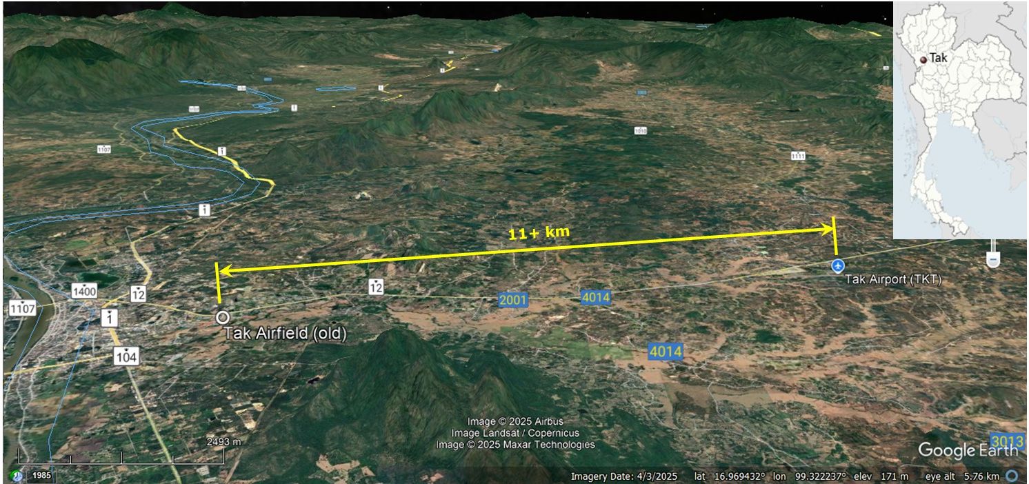
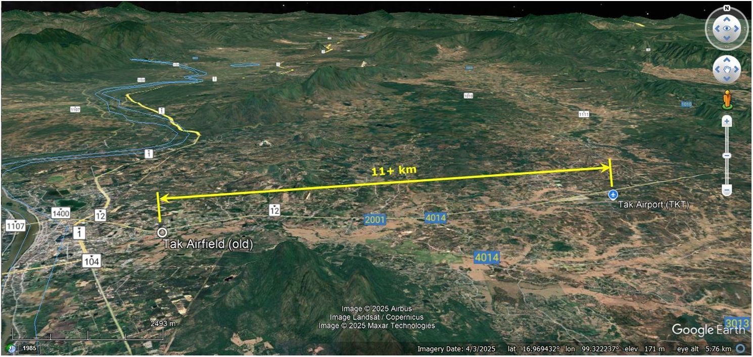
OLD TAK (RAHAENG, Raheng) AIRFIELD1 (Google Maps link). The site was once out-of-town, but it is now overtaken by sprawling urbanization which has resulted in the relocation of the facility 11 km east:2
Two names:
Rahaeng (ระแหง) derives from the Thai word meaning a narrow crack, split, or fissure in dry and arid ground. The area was given this name due to the dry, cracked terrain along parts of the Ping River basin. Tak (ตาก) literally means “to dry in the sun”, but local historical designations and regional traditions link the name of the ancient city to regional descriptors for high ground, elevated frontiers, or strategic mountain layouts.3
A city named Ban Tak was established by Jamadevi (พระนางจามเทวี), princess of the Lavo kingdom, around 663 CE. It became part of the Sukhothai kingdom through battles led by Ramkhamhaeng the Great and formed the main fortress on the western front. The city was moved further west and renamed Mueang Rahang when the Ayuthaya kingdom was lost to Burma during King Maha Thammaracha’s reign. The city was moved back to the east side of the Ping River during the early Bangkok period.4 Rahaeng province was officially redesignated and named Tak province (Changwat Tak) in 1916 (2459 BE) during the administrative reforms of King Rama VI.3
Side note on King Taksin: With given name Sin (สิน, meaning money or treasure), he rose to become governor of Tak, ie, Phraya Tak. As his name was Sin, he came to be called Tak-Sin during his time in Tak. So Taksin’s name developed by incorporating the name of the town, rather than the town adopting his name.5
Early Tak (Rahaeng)
Trade routes passed through Rahaeng long before air transport became available and that may have contributed to a decision to include it in a 1931-1932 road network that linked it with Mae Sot to the west and Phitsanulok to the east:
. . . the journey from Moulmein (Burma) to Tak took about six days over an area whose mountains were easy to cross and through which there were not less than eleven distinct caravan routes . . . .
Virginia M Di Crocco in her Preface to Hold Hallett, A Thousand Miles
on an Elephant in the Shan States (Bangkok: White Lotus, 1988), p xi
. . . Elephants . . . took 13 days in traveling from Lakon (Lampang) to Raheng . . . In following the White Elephant route from Lakon to Raheng, the road is easy, and no hills are crossed between the two places.
Hold Hallett, A Thousand Miles on an Elephant in the Shan States
(Bangkok: White Lotus, 1988), p 278
1907 Tak (Rahaeng)
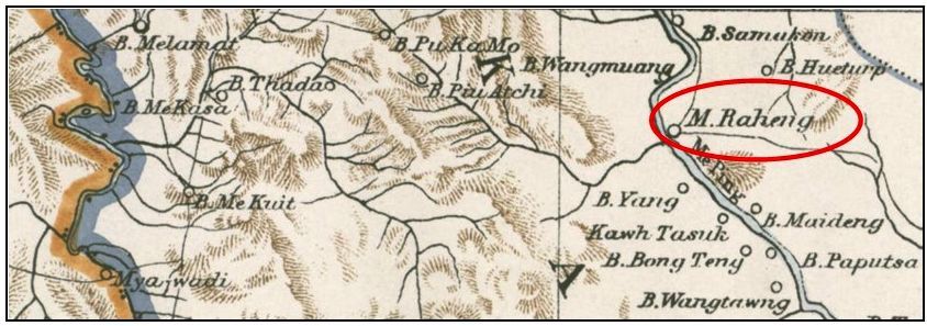
This 1907 map correctly called out the subject area as Raheng (aka, Rahaeng), since the name was changed to Tak by decree only in 1916:6
1931-1940
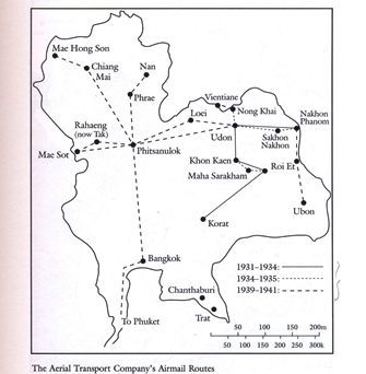
1931~1932: “The [Aerial Transport] Company built a string of of landing fields across the country beginning at Mae Sot on the Burma border, then proceeding to Rahaeng . . . and Nakhon Phanom. The company planned to have Mae Sot, Rahaeng, Phitsanulok, Udon, and Nakhon Phanom be all-weather fields. Rahaeng, Phitsanulok, Udon, and Nakhon Phanom would also have radio bearing stations.”7
Rahaeng was seen as being located at about the same latitude as Rangoon to which it was to be connected in the air network via Mae Sot, as well as being a commercial hub in its own right. From a 1941 US government survey of Thailand:8

“During 1938 the Aerial Transport Company, which since its inception had confined its air routes to the northeastern sector of the country, started plans for new services beyond . . . in their plans they added a third route to the west toward Burma. . . . [In mid May 1939] the company began the Phitsanulok-Mae Sot service . . . . The western route began in Phitsanujlok and flew to Mae Sot . . . Rahaeng (present day Tak). Operations . . . for the fiscal year ending March 31, 1940, the company completed . . . 196 flights over the Phitsanulok-Mae Sot route.”9
 15 March 1941
War Department, A Survey of Thailand (Siam), Civil Aviation provided a somewhat different version of the air transport network:10
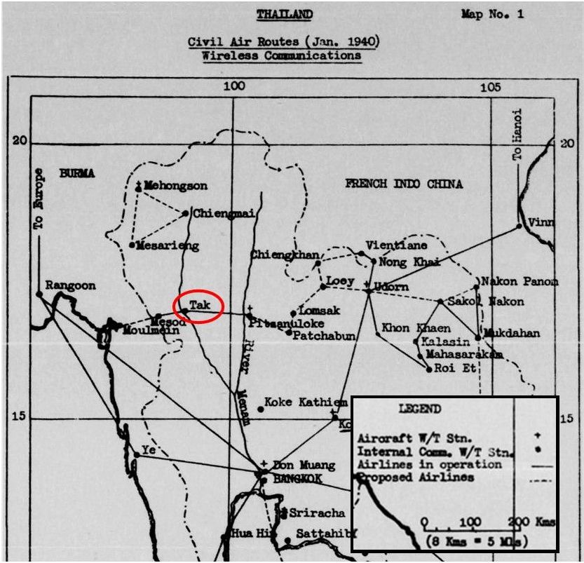
That government survey11 also noted that “The Phitsanulok-Tak-Mae Sot route of 200 km (124 mi) was flown twice weekly, using a Fairchild 24J12 and a DH [de Havilland] 80A Puss Moth13”:
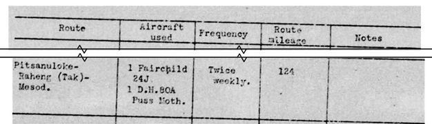
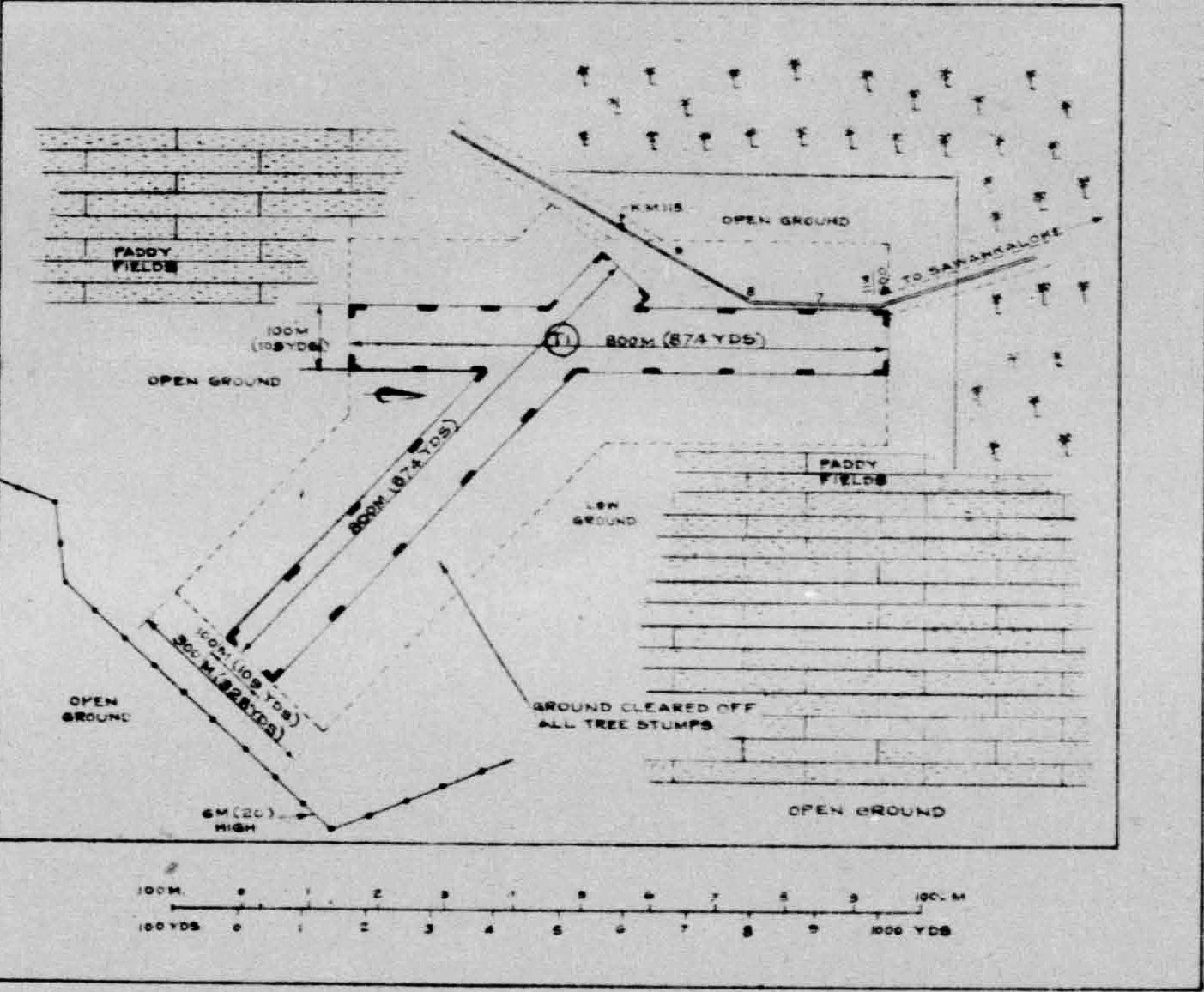
The Survey also details the Tak airfield in its Appendix I: Data & sketches of individual airfields in Thailand as Airdrome No. 20, Tak (Raheng), dated April 1940:14
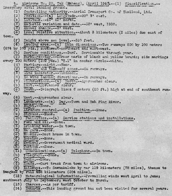
Transcript of key items:
(1) Classification. Emergency civil landing ground
(2) Controlling authority. Aerial Transport Co of Thailand, Ltd
(3) Position. N16°52 E99°08 . . .
(e) Local relative situation. About 3 kilometers (2 miles due east of town)
(4) Landing area
(a) Main dimensions. Two runways 800 by 100 meters (874 by 109 yds) southwest-northeast and east-west.
(b) Surface conditions. Turf. Serviceable through year. . . .
(10) Facilities. . . .
(b) Fuel and oil. None. . . .
(d) Hangars. None. . . . .
(f) Repairs. None
(11) Communications
(a) Telephone. In town.
(b) Telegraph. None
(c) Radio. None
(d) Roads. Cart track from town to airdrome.
(e) Railways. To [Sawankhalok] by car 119 km (75 mi), thence to Bangkok by rail 486 km (304 mi). . . .
(14) Remarks. This landing ground has not been visited for several years.
Sketches of facility:15
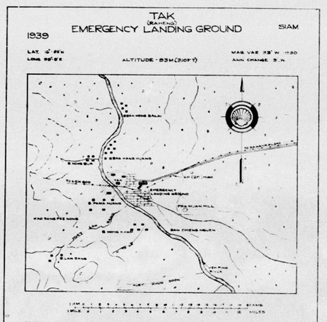
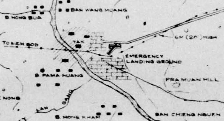
Area circled in red is enlarged below:
19 December 1941
An escorted locally modified photo-recon RAF 67 Squadron Buffalo16 photographed Raheng (Tak).17
23 December 1941
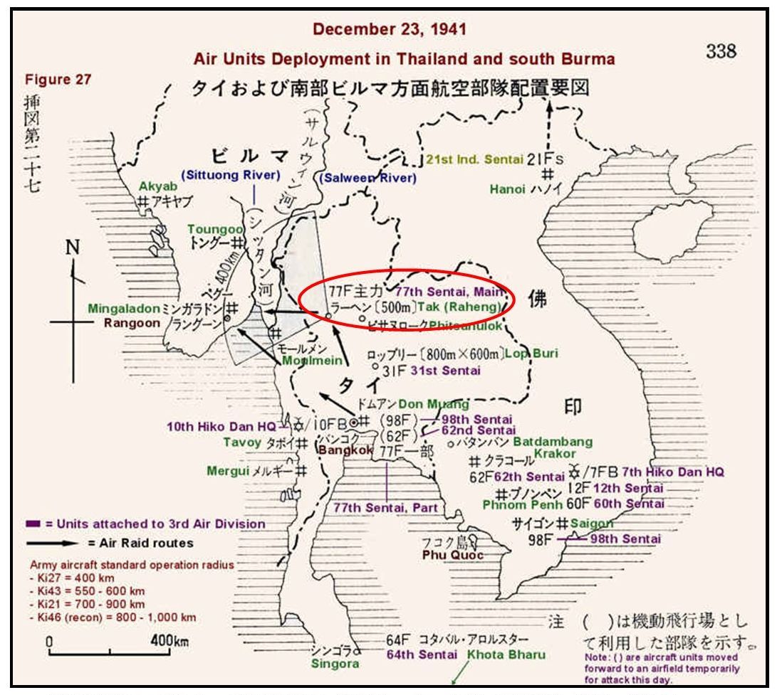
The Imperial Japanese Army (IJA) entered Tak and the Imperial Japanese Air Force 77th Sentai (IJAAF) occupied the Tak airstrip:18
23 December 1942:
Flt Sgt Martin H Huggard in RAF 60 Squadron Blenheim19 L4915, patrolled along the corridor:20
- Chumphon
- Kamphaeng Phet
- Tak
- Mae Sot
25 December 1941
An IJAAF Ki-27 piloted by a Sgt Ono returning to homebase Rahaeng after being damaged in a “Christmas raid” on Rangoon crashed near Omkoi, about 130 km NW of Rahaeng. Though wounded, Ono survived.
An IJAAF Ki-21 returning from a “Christmas raid” on Rangoon crashed on a mountain ridge NW of Rahaeng. There were no survivors.
28 December 1941
. . . [A]n advance party of a platoon of infantry and a party of the [Burma Independence Army] . . . started from Tak for Mae Sot.21
03 January 1942
IJAAF 77th Sentai Ki-27s22 flying out of Lampang refuelled at Tak, attacked Rangoon; 2nd AVG P-40s23 attacked returning IJAAF aircraft claiming up to four shot down plus up to four destroyed on the ground.24 WO Yokoyama was badly wounded when his Ki-27 was shot down.
08 January 1942
2nd AVG P-40s assigned to attack Mae Sot, mistakenly overflew its target to instead hit Tak; the IJAAF recorded the attack: four Ki-27s were burned along with a transport plane and three Ki-27s were damaged; one P-40 was downed with pilot, Charley Mott, captured.25
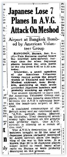
Lethbridge Herald, 09 Jan 1942, p 2, printed the AP article on the attack which quoted Allied sources mistakenly locating it in Mae Sot:
 Japanese Lose 7 Planes In AVG Attack on Meshod
_____
Airport at Bangkok Bombed by American Volunteer Group
RANGOON, Burma, Jan 9-(AP) — This Burmese capital capital heard the heaviest anti-aircraft barrage thus far when Japanese planes bombed the area north of the city from 4:45 to 5:45 am today.
Yesterday, a small squadron of the American Volunteer Group roared across the jungle wastes of Thailand and bombed Meshod airdrome, near Bangkok, destroying at least seven grounded Japanese bombers and probably wrecking an eigthth.
The assault appeared to have cost the American Volunteer Group one plane, for it was missing somewhere between the AVG’s operating base and the bomb-torn airport of Meshod.
A combined communique of the British army and air command said:
“AVG aircraft raided Meshod on Thursday. They destroyed seven enemy light bombers on the ground and probably eight. One AVG aircraft is missing as a result of this raid.” . . .
. . . The AVG’s destruction of seven bombers brought to 53 the total of Japanese planes certainly destroyed by Allied aircraft since the beginning of the war in this area. It is known that 20 to 30 Japanese planes failed to reach bases after raids on Burma or were probably destroyed on the ground.
09 January 1942
2nd AVG P-40s plus RAF 67 Squadron Buffalos attacked Tak destroying one IJAAF Ki-27 fighter and badly damaging another. One car was set afire, two buildings were damaged, and two Japanese soldiers were wounded.26
13 January 1942
An RAF 67 Squadron Buffalo fighter flew at low altitude in patrolling Tak and Mae Sot Airfields.27
17 January 1942
RAF 67 Squadron “shot up targets” in Tak and Mae Sot.28
20 January 1942
Two 67 Squadron Buffalos surveilled Rahaeng.29
21-22 January 1942
An overview of action around Tak Airfield from The London Gazette:30
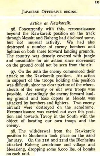
Transcript:
Japanese Offensive begins
Action at Kawkareik.
96. Concurrently with this, reconnaissance beyond the Kawkareik position on the track through Mesoht and Raheng had disclosed some, but not unusual activity. We had also destroyed a number of enemy bombers and fighters on both these forward landing grounds. The country was densely covered with jungle and unsuitable for air action since movement on the ground could not be seen from the air.
97. On the 20th the enemy commenced their attack on the Kawkareik position. Air Action in support of the troops holding this position was difficult, since no clear picture of the whereabouts of the enemy or our own troops was possible. Accordingly the enemy forward land ground and base depots at Mesoht was [sic] attacked by bombers and fighters. Two enemy aircraft were destroyed on the aerodrome. Reconnaissance was carried out over this position and towards Tavoy in the South with the object of locating our own troops and the enemy.
98. The withdrawal from the Kawkareik position to Moulmein took place on the 22nd January. On the 21st and 22nd the Blenheims attacked Raheng aerodrome and village and Mesarieng, dropping some 6,000 lbs of bombs on each raid.
22 January 1942
RAF 113 Squadron Blenheims dropped 6,000 lb of bombs each on targets Tak and Mae Sariang.31
22 January 1942
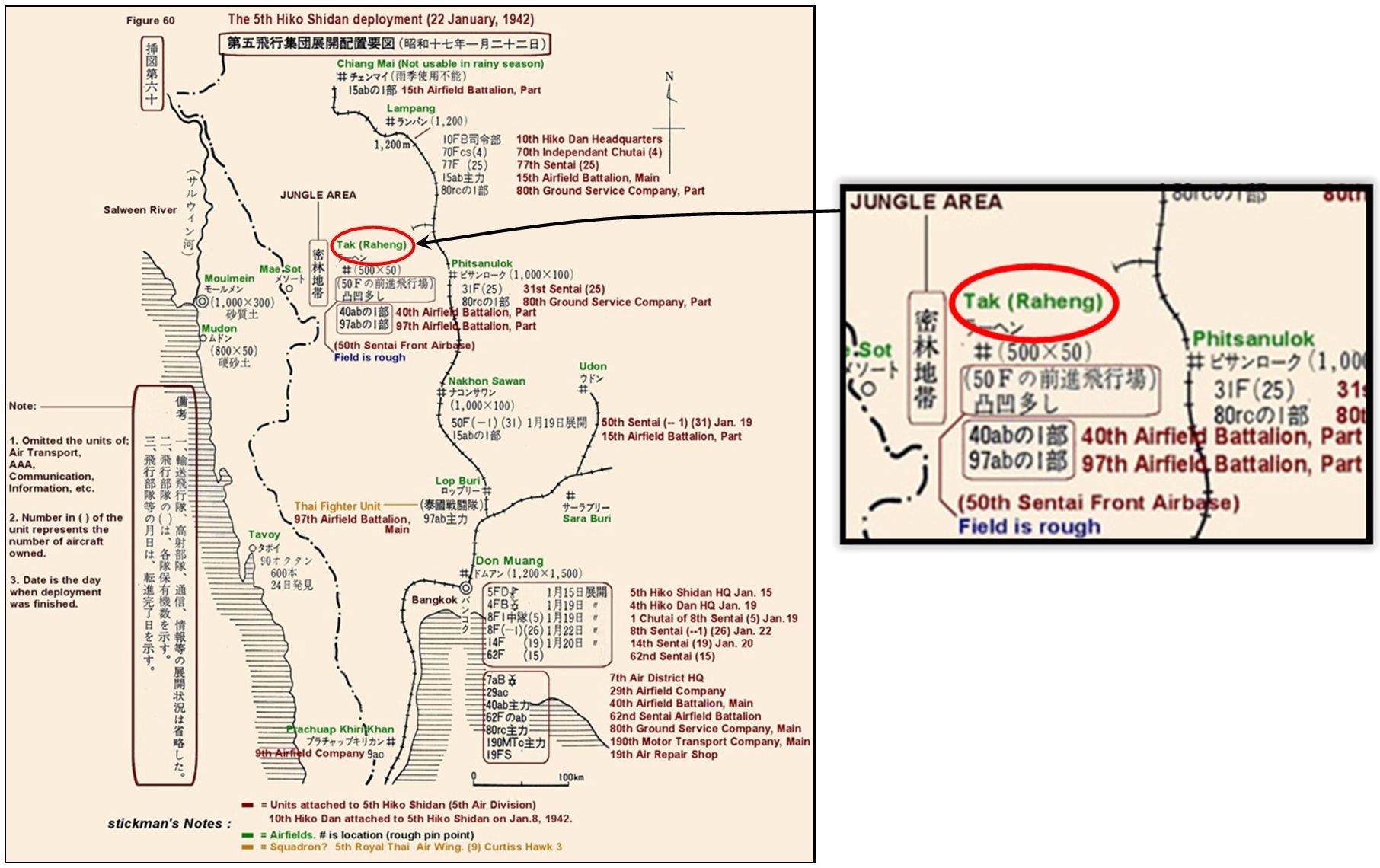
Parts of the 40th and 97th Airfield Batallions moved into Tak airfield, with the 77th Sentai moving north to Lampang, and the 50 Sentai replacing it in Tak. Note the JUNGLE AREA called out separating Tak from Mae Sot to the west — more than jungle, it was a rugged mountainous area:32
 Ammunition and fuel supplies in stock at Rahaeng (Tak):33
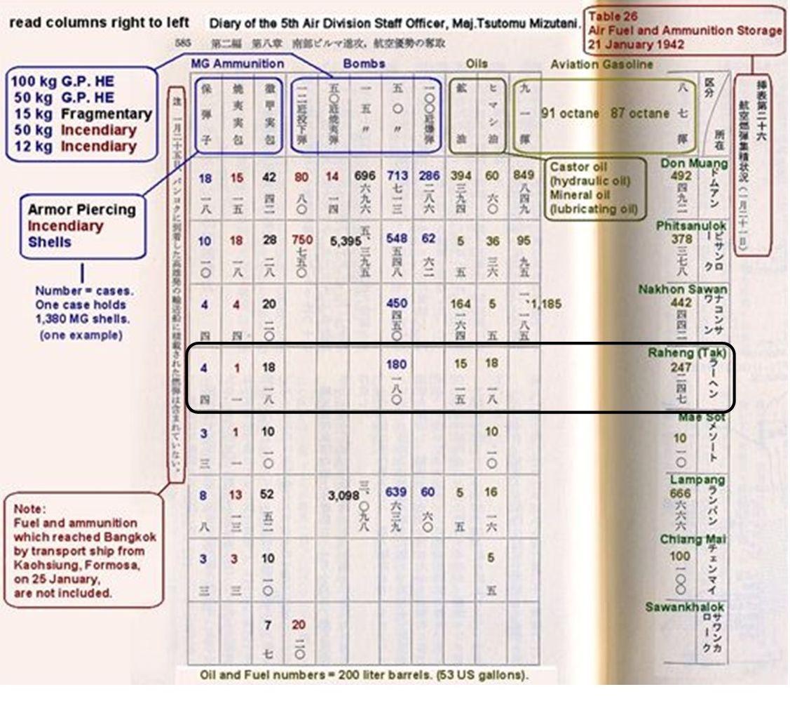
Transcript:
Ammunition:
● 4 cases of armor piercing
● 1 case of incendiary
● 10 cases of shells
● 180 cases of 50 kg incendiaries
Oils:
● 15 cases of hydraulic
● 18 cases of lubricating
27 January 1942
Time 1650 hrs. Allied aircraft attacked Tak Airfield; no damage was reported34
01 February 1942
An RAF 135 Squadron Hawker Hurricane35 patrolled Tak and Mae Sot.36
08 February 1942
Flt Off Ken Perkin flew RAF 135 Squadron Hurricane, No. Z4949, to photograph Tak and Mae Sot Airfields.37
15 February 1942
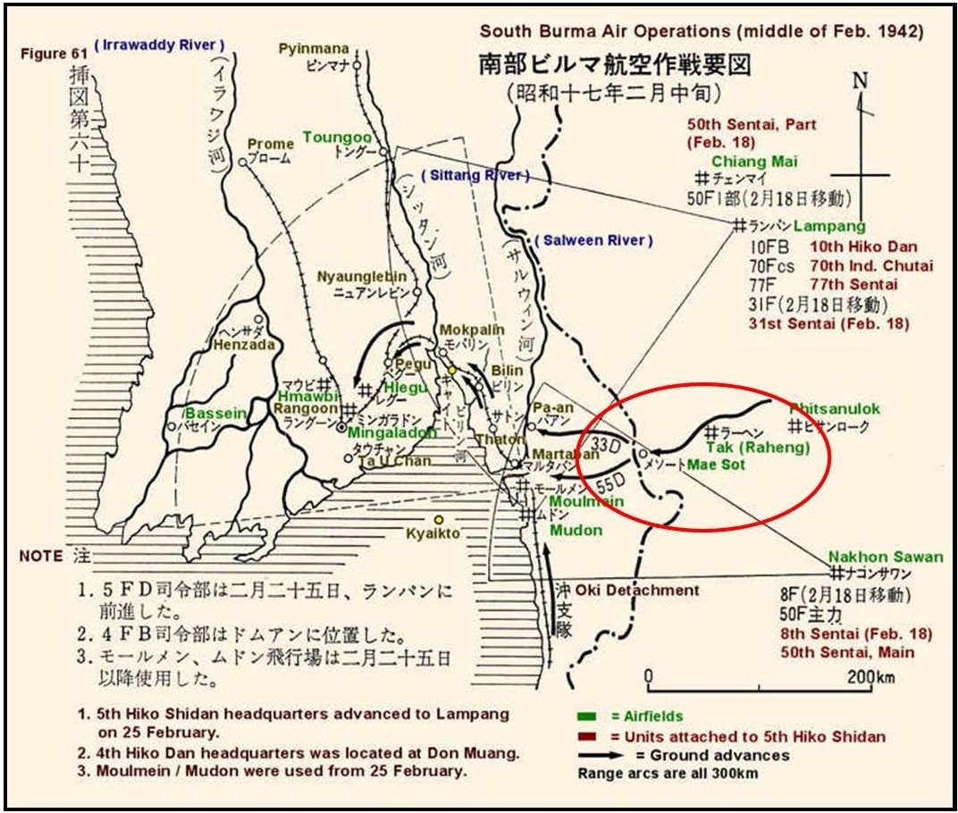
IJAAF Sentai had apparently moved on from Tak (and Mae Sot) as the IJA 33rd and 55th Divisions advanced into Burma from Mae Sot:38
24 February 1942
Six Flying Tiger P-40s attacked Tak Airfield and reported destroying two bombers and two fighter planes parked there.39
26 February 1942
An RAF Hurricane photographed Thai airfields, including Tak and Mae Sot.40
03 March 1942
The Tak air facility appeared to be no longer of significance to IJAAF operations:41
28 June 1942
Airport Directory South East:42
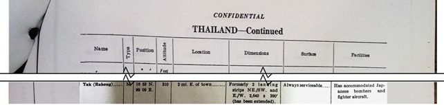
Transcript:
| M [military airport] | |
| 16°53 N 99°09 E | |
| 310 feet | |
| 2 mi E of town | |
| Formerly 2 landing strips NE/SW and E/W, 2640′ x 300′ (has been extended | |
| Very hard soil, usable even after heavy rains | |
| W/T and D/F [direction finder], hangar, fuel storage, British destroyed Japanese ships on ground in late January 1942 |
January 1943
The Rahaeng – Mae Sot — Moulmein Road, along which the 55th and 33rd Divisions had passed to Burma in early 1942, was inspected for use as a possible land supply route supplementing the Thai-Burma Railway; it was rejected because of failure to repair washouts and landslides resulting from subsequent monsoon rains, plus the rapid encroachment of tropical vegetation in the section between Tak and Mae Sot.43 It was clear that the Mae Sot airfield had been abandoned after its use in the land invasion of Burma.
September 1943
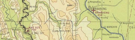
From World Aeronautical Chart (677) Gulf of Martaban dated Sep 1943 (with aeronautical information updated to Jan 1945). Note the dashed line connecting Tak (Brahaeng) with Mae Sot, indicating only a trail existed connecting the two [see January 1945 for information of aeronautical information]:44
19 October 1943
The Royal Thai Air Force and Japanese Army agreed to cooperate in building / improving various existing Thai air bases, with work to start immediately on some, including the existing Rahaeng.45
19 November 1943
An RAF 684 Squadron Mosquito46 took aerial photos of Tak and Mae Sot Airfields.47
17 December 1943
An RAF 684 Squadron Mosquito photographed airfields, including Mae Sot and Tak.48
December 1943
Airfield Report No 17
Record of Airfield Activity and Development – Thailand (p 23):49
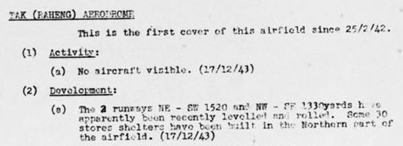
Transcript:
TAK (RAHENG) AERODROME
This is the first cover of this airfield since 25/2/42
1. Activity:
● No aircraft visible. (17/12/43)
2. Development:
● The 2 runways NE-SW 1520 and NW-SE 1330 yards have apparently been recently levelled and rolled. Some 30 stores shelters have been built in the northern part of the airfield.
(17/12/43)
Airfield Miniatures: Report No 17 included this miniature of the Tak runway with miscellaneous information:50
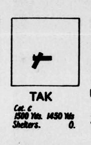
Transcript:
TAK
Cat (Category) C: (Liable to become unserviceable after rains)
(One runway:) 1500 Yds (the other:) 1450 Yds
Shelters: 0 (none)
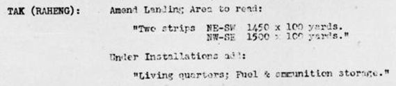
Amendment No 2 [1944] Amendments to Thailand Aerodrome List p 38:51
Transcript:
TAK (RAHENG):
Amend Landing Area to read:
“Two strips NE-SW 1450 x 100 yards
NW-SE 1500 x 100 yards”
Under Installations add:
“Living quarters; fuel & ammunition storage.”
03 January 1944
A USAAF 21st Squadron F-5A52 patrolled northern Thailand, and included Tak.53
12 January 1944
An RAF Squadron Mosquito photographed northern Thai airfields including Tak.54
29 January 1944
An Allied aircraft photographed [old] Tak and Mae Sot Airfields.55
February 1944
Airfield Report No 19
Record of Airfield Activity and Development – Thailand, p 25:56
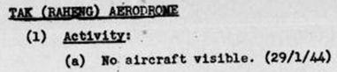
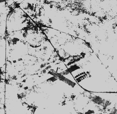
Tak (Raheng) Airfield57
Approximate location: N16°52.65 E99°08.40:
Record of Airfield Activity and Development – Thailand, p xix:58

Transcript:
TAK (RAHENG) AIRFIELD
Activity: Occasional reconnaissance throughout the month has only revealed the presence of one small aircraft on 21/4/44
03 March 1944
One of three RAF 684 Mosquito photographed various Thai airfields, including Tak.59
28 March 1944
One of three RAF Squadron Mosquitos photographing Thai airfields, included Tak.60
21 April 1944
An RAF 684 Squadron Mosquito photographed various airfields, including Tak.61
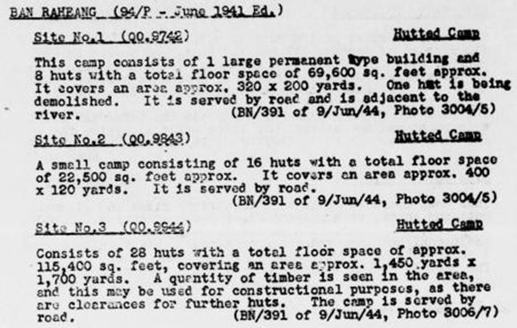
June 1944
Airfield Report No 23
Record of Airfield Activity and Development, p 6:62

Air Command SEA, Central Photo Interpretation Center, CPIC, SEA, Detailed Interpretation Report no P.59, Barracks, Hutted Camps, Stores and Dumps. p 47:63
Southeast Asia (Burma, French Indochina, Malaya, Thailand) Enemy Airfield Information, 29 July 1944, p 69:64
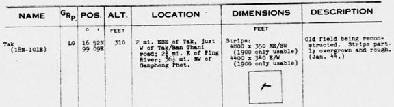
Transcript:
NAME: Tak (18N-101E)
GRP: LG [landing ground]
POSITION: 16°52N 99°09E
ALTITUDE: 310 feet
LOCATION: 2 mi ESE of Tak, just W of Tak/Ban Thani road;
. 2¼ mi E of Ping River; 36½ mi NW of [Kamphaeng] Phet
DIMENSIONS: Strips:
. 4800 x 350 NE/SW (1900 only usable)
. 4400 x 340 E/W (1900 only usable)
DESCRIPTION: Old field being reconstructed. Strips partly overgrown and rough (Jan 44)
09 June 1944
An RAF 684 Squadron Mosquito photographing various airfields, included Tak.65
September 1944
Road and Railroad Report dated September 1944
Siam – Roads and Railroads, Appendix “A”, p 58:66
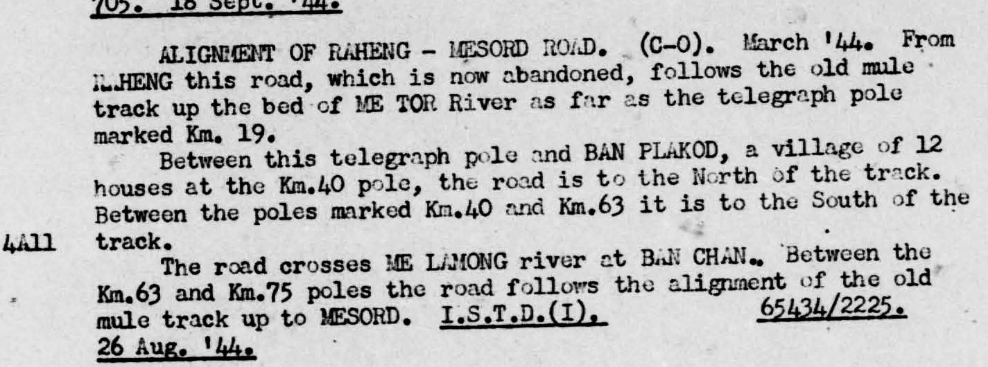
and p 61:67


Transcript:
[KAMPHAENG] PHET (16°27 99°27) – RAHENG (16°52 99°07). This is part of the road [NAKHON] SAWAN – [RAHENG]. This road is still under construction and according to PIR information in June considerable work had still to be done. A road is complete between RAHENG and MOULMEIN.
LOPBURI-TAK (RAHENG) – CHIENGMAI. A road is reported under construction from both ends. AT the NORTH end it is complete as far as HOHD. The completion of this road will link TOURANE (DANANG, French Indochina) and MANDALAY with a direct road short circuiting BANGKOK. The section between [NAKHON] SAWAN and RAHENG is already complete and there is a half finished concrete bridge between [NAKHON] SAWAN and PAKNAM PO. Information as to this through road project is unconfirmed.
October 1944
Airfield Report No 27
Record of Airfield Activity and Development, p 10:68
 Transcript:
TAK (RAHENG) AIRFIELD:
Activity: Infrequent cover during the month failed to disclose the presence of any aircraft (21/OCT/44)
Development: Surfacing of the EW runway has been undertaken and there is evidence of considerable track activity. Some small huts have been erected at the intersection of the runways. (21/OCT/44)
15-31 Oct 1944
Road and Railroad Communication Report
Siam – Roads and Railroads, Appendix “A”, p 28.
“From JICA/CIB/SEA.New Delhi, India Report No 9157D to 15 November 1944”:69
 Transcript:
SIAM – BURMA. A report has been received from Chinese sources indication that:
The road TAK-MAE SOT-MOULMEIN is being used by the Japs for the transport of troops and supplies into BURMA.
21 October 1944
An RAF 684 Squadron Mosquito photographed northern Thai airfields, including Tak.70
26 October 1944
An RAF 684 Squadron Mosquito photographed Tak and Chiang Mai Airports.71
03 December 1944
A USAAF 40th Squadron F-5 photographed Tak Airfield and Uttaradit roads.72
04 December 1944
Allied aircraft photographed Tak Airfield.72
07 December 1944
Two RAF Bristol Beaufighters73 patrolled the Chiang Mai-Tak Route, but found no targets.74
12 December 1944
An RAF 27 Squadron Bristol Beaufighter patrolled the Tak-Mae Sot Road.75
14 December 1944
A USAAF 40th Squadron F-5 photographed Tak, Mae So, and Uttaradit Airfields.76
31 December 1944
Tak (Raheng) Airfield (CIO, HQ, Air Command, South East Asia ~31 Dec 1944)
Caption to sketch of airfield:77
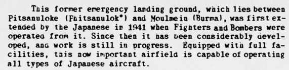
“Airfield schedule” Tak (Raheng) Airfield:78
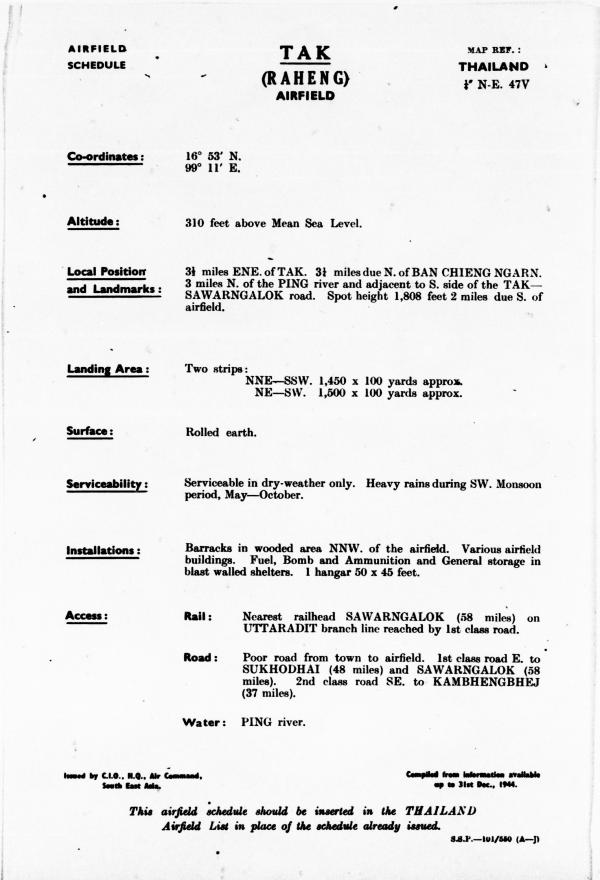
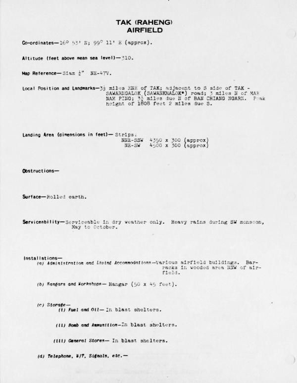
Transcript of selected facts:
Landing Area: two strips:
. NNE-SSW 1450 x 100 yards approx.
. NE-SW 1500 x 100 yards approx.
Installations:
-
-
- Barracks in wooded area NNW of the airfield.
- Various airfield buildings. Fuel, bomb, and ammunition and general storage in blast walled shelters.
- 1 hangar 50 x 45 feet.
-
Access: (only shown on first description)
-
-
- Rail: Nearest railhead SAWARNGALOK [Sawankhalok] (58 miles) on UTTARADIT branch line reached by 1st class road.
- Road: Poor road from town to airfield. 1st class road east to SUKHODHAI (48 miles) and SAWARNGALOK (58 miles). 2nd class road SE to KAMBHENGBHEJ [not found] (37 miles)
-
Record of Airfield Activity and Development:79

Transcript:
TAK AIRFIELD
Activity: Two covers of the 3rd and 4th failed to disclose presence of aircraft.
Development: Additional tracks and surfacing of NE-SW runway show considerable activity. Taxi strip and large revetment being constructed.
Jan 1945
From World Aeronautical Chart (677) Gulf of Martaban Sep 1943 (with aeronautical information updated to Jan 1945). Tak / Rahaeng appears as “Brahaeng”. The “L” shaped block at Brahaeng is the symbol for a city of size 25,000 to 100,000. The cross at Brahaeng indicates that the facility is an emergency landing field:44
Jan 1945
Airfield Report No 30
A survey of present and future trends in Japanese airfield development . . . . In Siam:80
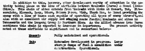
Transcript:
. . . other development worthy of attention is the activity taking place on the line of airfields between Moulmein (Burma) & Hanoi (Indo China) [following links are offsite] . . . .
Moulmein81
Mae Sot82
Tak83
Phitsanuloke84
Lomsak85
Loei86
Udorn87
Nakhon Phanom88
Vinh89
Thanh Hoa90
Hanoi (Gia Lam)91
As tracked on this map:92
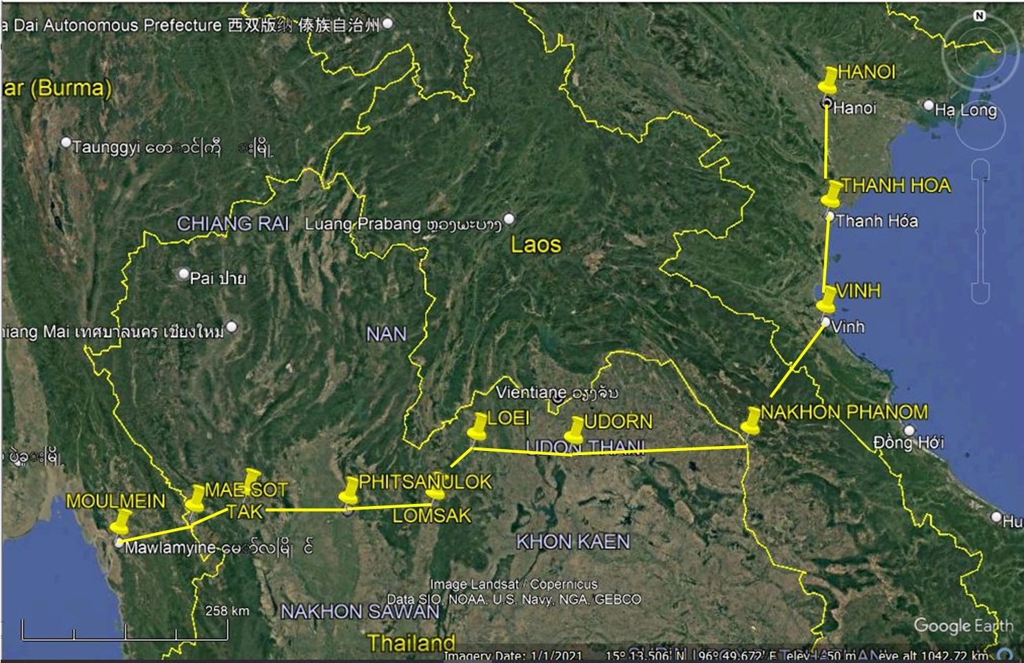
. . . providing the enemy with a line of bases each capable of operating all types of enemy aircraft, and also with an excellent air supply and staging route feeding Moulmein and sites in Tenasserim and the Lampang Group in Northern Siam. As the Allied advance into Burma continues this chain is expected to increase in importance. The present activity noted at these airfields is significant and is summarized below:
Mesawt: Fully maintained and operational.
Tak: Extensive development in progress. Large storage dumps of fuel & ammunition under construction. Operational.
Record of Airport Activity and Development:93

Transcript:
TAK (RAHENG) AIRFIELD
Activity: Occasional cover failed to reveal presence of any aircraft. (14/JAN/45)
Development: Surfacing of NE-SW runway and taxi tracks continues and work has begun on surfacing of WNW-ESE strip. Shelter construction continues.
01-15 Jan 1945
Transportation Report – Road, Railroad, and Inland Waterways
SIAM Appendix “A: Siam – Roads & Railroads, p 24:94
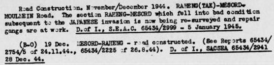
Transcript:
Road Construction, November/December 1944. RAHENG (TAK)-MAE SOT-MOULMEIN Road. The section RAHENG-MAE SOT which fell into bad condition subsequent to the JAPANESE invasion is now being re-surveyed and repair gangs are at work. D of I, SEAC 65434/2999-5 January 1945.
(B-O) 19 Dec. MAE SOT-RAHENG-road constructed. (see Reports 65434/2754/5 of 24.11.44, 66434/2225 of 26.8.44). D of I, SACSEA 65434/2941 29 Dec 44.
06 January 1945
An RAF 684 Squadron Mosquito photographed the Northern Railway from Bangkok to Sawankhalok and the road connection from there to Tak.95
11 January 1945
A USAAF 40th Squadron F-5 photographed the road connecting Uttaradit and Mudon, Burma, which probably included covering Tak.96
15-31 Jan 1945
Transportation Report, Road, Railroads, and Inland Waterways:97

Transcript:
4A06 – NAKHON SAWAN 16°40/100°08 to RAHENG (TAK) 16°52/99°07 to LAMPANG 18°17/99°29 to CHIANG MAI 18°46/99°00
REFERENCE (A-1) A monthly ISTD summary report describing the rds of SIAM, RAHENG to PAKNAMPHO 36°42/100°07. RAHENG to LAMPANG. Appendix (Interrogation of two SWISS nationals in SIAM). . . .
01 March 194598
Transportation Report-Road, Railroad, & Inland Waterways:99

Transcript:
4A06-NAKHON SAWAN 15°40/100°08 to RAHENG (TAK) 16°52/99°07 to LAMPANG 18°17/99°29
20Jun45. ?? NAKHON SAWAN-RAHENG rd [future Thai Route 1]. Approx 20 miles of this rd are covered in a broken stretch on each side of BAN KHLONG KHLUNG [N16°13 E99°43]. The serviceability of this stretch of rd varies along its length, at time being merely a cart-track, but mainly being in a stage well advanced towards a motor rd.
BAN KHLONG KHLUNG. Preliminary clearing has been carried out to link this village to the main NAKHON SAWAN-RAHENG rd still under construction. CFIX A 3018.
March 1945
Airfield Report No 32
Record of Airport Activity and Development:100

Transcript:
TAK (RAHENG) Airfield:
Activity: Infrequent cover failed to reveal presence of any aircraft.
Development: Both taxi tracks north of the WNW-ESE strip (19/MAR/45) have been extended. There are now 5 completed aircraft shelters.
06 March 1945
A USAAF 40th Squadron F-5 photographed the Tak-Lampang Road, including the Tak Airfield.101
07 March 1945
USAAF 40th Squadron F-5s photographed various land routes in northern Thailand including the Lampang-Tak Road.102
April 1945
Airfield Report No 33
Record of Airport Activity and Development:103

Transcript:
TAK (RAHENG) Airfield:
Activity: Occasional cover failed to reveal the presence of any aircraft. (19th April 1945)
Development: Taxi-track construction continues and two buildings have been added in the camp area west of the airfield.
Siam: List of airfields and seaplane stations
Amendment List No 1 (1945):104

Transcript:
TAK (RAHENG) A/F: Installations: Add:
Taxi tracks: Dispersal areas; Airfield shelters
06 April 1945
A USAAF 40th Squadron F-5 photographed Tak Airfield.105
19 April 1945
An Allied aircraft took pictures of several airfields in northern Thailand, including Tak.106
May 1945
Airfield Report No 34
TAK (RAHENG) A/F SIAM107
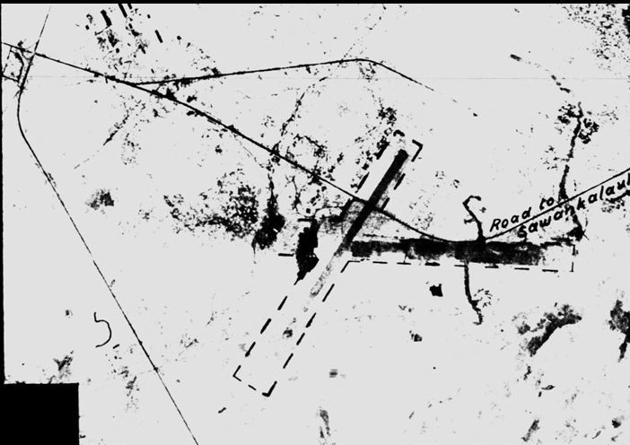
TAK (RAHENG) A/F SIAM
(same publication, but better quality copy)108
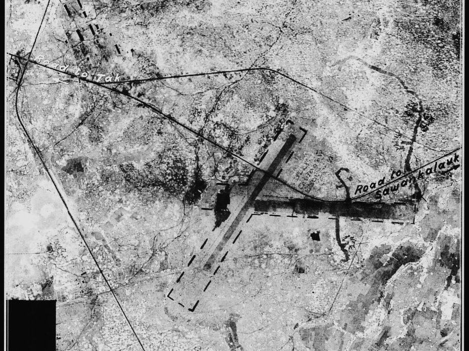
Note that north is up-page on the two images above.
Siam: List of airfields and seaplane stations
Amendment List No 2 (1945):109
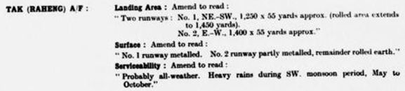
Transcript:
TAK (RAHENG) A/F:
Landing Area: Amend to read:
“Two runways: No. 1, NE-SW, 1,250 x 55 yards approx (rolled area extends to 1,450 yards) No. 2, E-W, 1,400 x 55 yards approx”
Surface: Amend to read:
“No. 1 runway metalled. No 2 runway partly metalled, remainder rolled earth.”
Serviceability: Amend to read:
“Probably all-weather. Heavy rains during SW monsoon period, May to October.”
09 May 1945
An RAF 357 Squadron Liberator VI110 transported a Siri Thai team, Operation Rocket, over Tak Province in support of Operation Neronian.111
27 May 1945
An Allied aircraft took photos at Tak Airfield.112
12 June 1945
An RAF 356 Squadron Liberator VI, after an unsuccessful mission to drop supplies to a Seri Thai outpost, dropped leaflets in Tak Province.113
June 1945 (date uncertain)
An RAF 681 Squadron Spitfire114 photographed targets around Tak, among many other areas.115
15 Jul-01 Aug 1945
Transportation Report, Road, Railroads, and Inland Waterways
Section II Roads – Siam:116

Transcript:
RAHENG (TAK) 16°52/99°07 to MAE SOT 16°39/98°32 to KYONDO [Burma] 16°36/98°03
6July45. B-3. The JAPANESE are using conscripted labor on a large scale to repair the rd from RAHENG -MAE SOT via MERALES 00 3456 . . . .
_______ _______ _______
December 1948
World Aeronautical Chart (677) Gulf of Martaban dated Dec 1948 shows the old runway, running roughly east-west at Tak:117
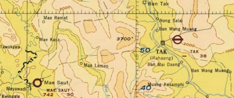
1954
Maps of Airports in the Kingdom of Thailand (unpublished):118
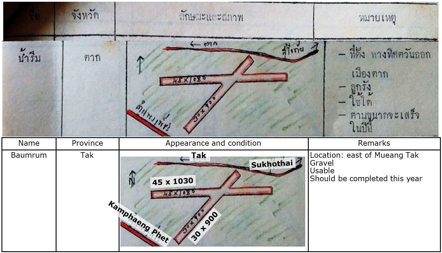
These dimensions, all approximate, and headings (estimated here) don’t compare very well with the 31 December 1944 schedule:
30m x 900m (1,000 yd x 32yd) vs NNE-SSW 1,450 x 100 yards
30m x 1030m (1,100 yd x 32 yd) vs NE-SE 1,500 x 100 yards
01 Feb 1971
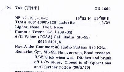
Air America listed Tak as closed 30 Sep 1970; so there may have been no air service to Tak from that date until the new airport opened more than seven years later in 31 May 1977;119 perhaps contradictorily is 1983 Tactical Pilot Chart that follows, see below. Note that the Air America listing does not mention the NE/SW runway:
 31 May 1977
The new Tak airport opened adjacent to Thai Route 12 about 11 km ENE of the old airport, which presumably was closed on that date or shortly after:120
1983
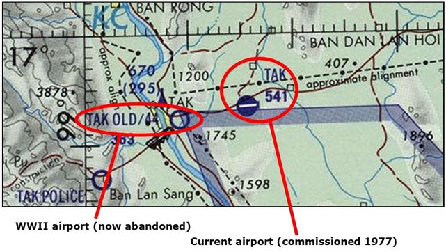
Tactical Pilot Chart: TPC J-10 (extract) conversely called out both old and new facilities, so perhaps the old airfield continued active, overlapping with the new airport through at least 1983:121
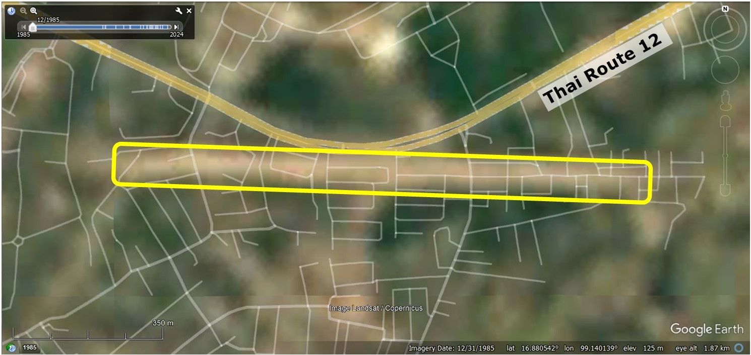
Google Earth view of old airfield site (Dec 1985), note that the NE/SW runway may no longer be present — later aerials, of higher resolution, seem to confirm that:122
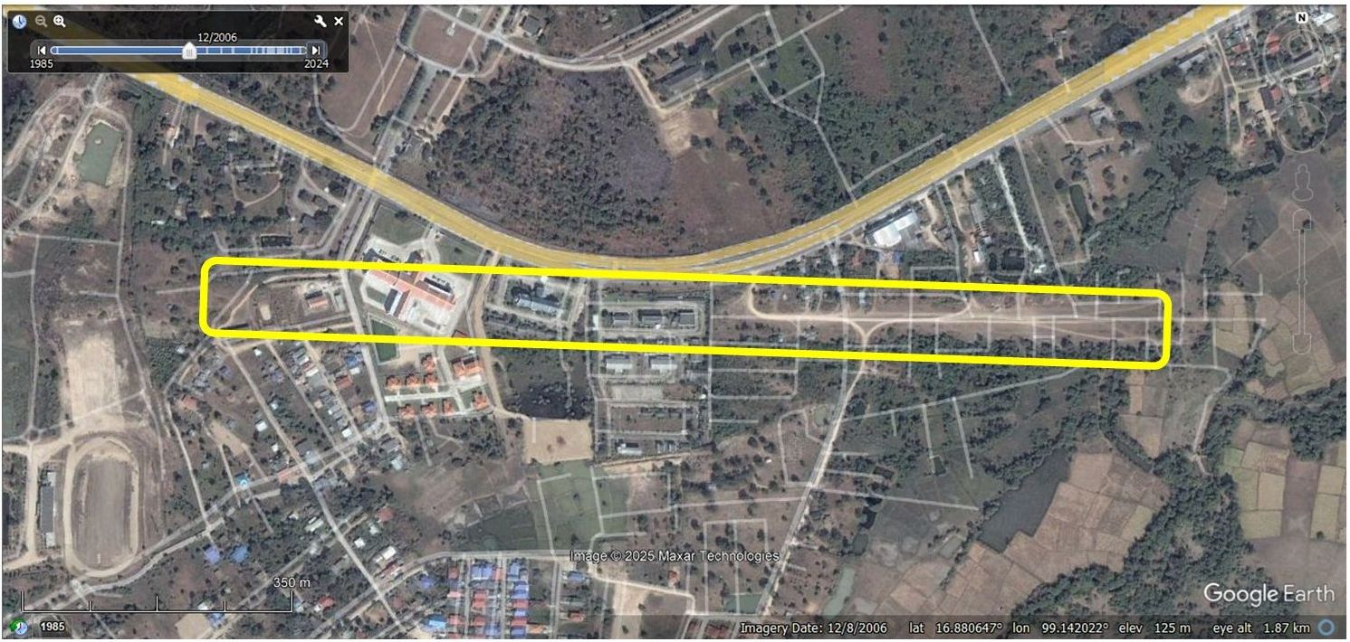
Google Earth view of old airfield site (Dec 2006):123
Google Earth view of old airfield site (present day):124
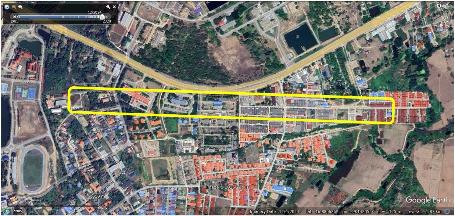
We visited the site in September 2025 and could find no evidence of there ever having been an airstrip at that location. Numerous Tak provincial governmental buildings now dot the area, presumably taking advantage of the availability of public land. However, there are also some well-maintained residences, as well as what might be squatters’ structures scattered around.
| First published on Internet | ||
Last Updated on 16 September 2026
- N16°52.65 E99°09.02; my ref: \02370 Other locations\02370 Tak (Rahaeng)\_Tak Airfield.docx[↩]
- Google Earth oblique view locating old airfield and new airport; my ref: \02370 Tak (Rahaeng)\Old aerials markup.pub, sht 10; Tak airports OBLIQUEa.jpg, annotated by author using Microsoft Publisher[↩]
- www.wisdomlib.org as referenced by Google Search AI.[↩][↩]
- Wikipedia: Tak Province>History (offsite link) [↩]
- Wikipedia: Taksin>Early career (offsite link) [↩]
- Source: University of Wisconsin Madison: India and Adjacent Countries: Rangoon (offsite link); my ref: \02370 Tak (Rahaeng)\16,096 094 Rangoon-agdm_19376_full-1907 pt.jpg[↩]
- Young, EM, Aerial Nationalism (Washington: Smithsonian, 1995), p 84[↩]
- A Survey of Thailand (Siam) (Washington: War Department, 15 March 1941), p 6; my ref: \03400 USFE Cmd Documentation\US Archives\USAF Reel A2874 p1364; my ref: \02370 Tak (Rahaeng)\400000 USG A2874 p1364 Raheng commerce.jpg[↩]
- Text: Young, op cit, pp 99-100. Map: Young, op cit, p xi; my ref: \02370 Mae Sot\_Mae Sot Airfield.docx (annotated by author using Microsoft Word.[↩]
- My refs: \03400 USFE Cmd Documentation\USAF Archives\_TOPICS\Tak\400100 A2874 1467 MHS-CNX-MS.jpg in \03400 USFE Cmd Documentation\USAF Archives\_TOPICS\Tak\Maps.pub, sht 1; and \03400 USFE Cmd Documentation\USAF Archives\_TOPICS\Tak\400100 A2874 1467 MHS-CNX-MS.jpg; annotated by author using Microsoft Word.[↩]
- My ref: \03400 USFE Cmd Documentation\USAF Archives\USAF Reel B1750 p 1748; my ref: \02370 Other locations\02370 Mae Sot\Old runway location.pub, sht 13[↩]
- Wikipedia: Fairchild 24 (offsite link) [↩]
- Wikipedia: de Havilland Puss Moth, (offsite link) [↩]
- My ref: \03400 USFE Cmd Documentation\USAF Archives\_TOPICS\Tak\400400 USAF B1750 p1806 Tak AF plan Apr 40.jpg[↩]
- My ref: \03400 USFE Cmd Documentation\USAF Archives\_TOPICS\Tak\400400 USAF B1750 p1807 Tak AF plan Apr 40.jpg[↩]
- Wikipedia: Brewster Buffalo F2A (offsite link) [↩]
- Shores, Bloody Shambles vol 1 (London: Grub Street, 1992), p 240[↩]
- My refs: \03302 034 Senshi Sosho vol 34 (IJAAF drive)\MAPS, markups fm Warbirds\SS34 p 583 item 2 N pt.jpg; \02370 Mae Sot\Mae Sot Warbird blog.pub sht 6; 02370 Tak (Rahaeng)\23 Dec 1941 IJA positns.jpg[↩]
- Wikipedia: Bristol Blenheim (offsite link) [↩]
- Thomas 1999: 29 per History of the Royal Thai Air Force during the Great East Asia War, ibid, p 63[↩]
- Ian Lyall Grant & Kazuo Tamayama, Burma 1942 (Chichester: Sampi, 1999), p 60[↩]
- Wikipedia: Nakajima Ki-27 (offsite link) [↩]
- Wikipedia: Curtiss P-40 Warhawk (offsite link) [↩]
- Ford 1991: 160; Hammel 1998: 11; Olynyk 1986: np; Shores & Cull 1998: 253, per RTAF History, p 73[↩]
- Shores, ibid, p 254[↩]
- Ford 1991, pp 170-171; Hammel 1998, p 11; Shores & Cull 1998, p 255, per RTAF History, p 71[↩]
- Shores & Cull 1998: 256 per RTAF History, p 73[↩]
- Shores, etal, p 257[↩]
- RTAF History, pp 74-75[↩]
- The London Gazette, March 11th 1948 (Second Supplement), page 10 (offsite link); my ref: \02370 Mae Sot\Mae Sot Fold3\Page 10.jpg[↩]
- Shores, ibid, p 260[↩]
- Nanpo shinko rikugun koku sakusen (Japan Defense Agency, 1970); my refs: \03302 034 Senshi Sosho vol 34 (IJAAF drive)\MAPS, markups fm Warbirds\SS34 p 583 item 2 pt.jpg; \02370 Mae Sot\Mae Sot Warbird blog.pub sht 8; \02370 Tak (Rahaeng)\Tak 22 Jan 1941 IJA positns.jpg[↩]
- Senshi Sosho 34 pp 584-585; my ref: \03302 034\Senshi Sosho vol 34 (IJAAF drive) \573-585\584-585.jpg; my ref for markup: \03302 034 Senshi Sosho vol 34 (IJAAF drive)\MAPS, markups fm Warbirds\aviationfuelandammunitiqm1.jpg; \02370 Mae Sot\Mae Sot Warbird blog.pub sht 5[↩]
- Shores & Cull 2000: 256; Thomas 1999: 30, per RTAF History, p 74[↩]
- Wikipedia: Hawker Hurricane (offsite link) [↩]
- Shores & Cull 2000: 256; Thomas 1999: 30, per RTAF History, p 78[↩]
- Thomas 1999: 30, per RTAF History, p 80[↩]
- my refs: \03302 034 Senshi Sosho vol 34 (IJAAF drive)\MAPS, markups fm Warbirds\SS34 p 597 item 3.jpg; \02370 Mae Sot\Mae Sot Warbird blog.pub sht 9; \02370 Tak (Rahaeng)\Tak 15 Feb 1941 IJA positns.jpg[↩]
- Shores & Cull 2000: 274 per RTAF History, p 83[↩]
- Thomas 1999: 31 per RTAF History, p 83[↩]
- My refs: \03302 034 Senshi Sosho vol 34 (IJAAF drive)\MAPS, markups fm Warbirds\SS34 p 607, item 4.jpg; \02370 Mae Sot\Mae Sot Warbird blog.pub sht 10; \02370 Tak (Rahaeng)\Tak 03 Mar 1942 IJA positns.jpg[↩]
- South East Asia: Airport Directory (Washington: USAAF, 28 Jun 1942), p 9; my ref: \03400 English language sources\03400 USFE Cmd Documentation\_Airfields List (Sak)\1942 Originals\19420628-09.jpg: \1942 origs meld.pub sht 2[↩]
- Sensei Sosho (the official Japanese military history of World War II, Imphal Operation, vol 15, pp 141-142; my ref: \03302 015 Senshi Sosho vol 15 (Imphal op)\SS15 JOSH raw xlatn\SS15 p140.jpg; \03302 015 Senshi Sosho vol 15 (Imphal op)\SS15 JOSH raw xlatn\SS15 Hak xlatn 111608.rtf[↩]
- source: McMaster Collection, Canada Chart (677) Gulf of Martaban (offsite link); my ref: (1)\bPROJECT\_MAPS\THAILAND Maps\COLLECTN McMASTER\677-macrepo_76844.jpg;(2)\02370 Other locations\02370 Tak (Rahaeng)\677-macrepo_76844 pt.jpg[↩][↩]
- RTAF History, p 150[↩]
- Wikipedia: De Havilland Mosquito (offsite link) [↩]
- RTAF History, p 155[↩]
- RTAF History, p 159[↩]
- My ref: \03400 USFE Cmd Documentation\USAF Archives\_TOPICS\Tak\431200 USAF A8055 p0381 Phre LG, Tak AF status Dec 43.jpg[↩]
- issued by CIO, HQ, Air CSEA; produced by Int III; my ref: \03400 USFE Cmd Documentation\USAF Archives\_TOPICS\Tak\440100 USAF A8055 p0423 Thai AF miniatures Tak Jan 44.jpg.[↩]
- My ref: \03400 USFE Cmd Documentation\USAF Archives\_TOPICS\Tak\440100 USAF A8055 p0477 Tak AF status~Jan 44.jpg[↩]
- Lockheed F-5 Lightning Model (offsite link) [↩]
- 21 PRS (21st Photographic Reconnaissance Squadron–Flight Intelligence Reports) per RTAF History, p 168[↩]
- RTAF History, p 171[↩]
- RTAF History, p 174[↩]
- My ref: \03400 USFE Cmd Documentation\USAF Archives\_TOPICS\Tak\440100 USAF A8055 p0525 Tak AF Jan 44.jpg.[↩]
- CPIS M03 No 817 B N/94 (12-1-44) AHQ/7401G (part); my ref: \03400 USFE Cmd Documentation\USAF Archives\_TOPICS\Tak\440100 USAF A8055 p0564 Tak aerial Jan 44.jpg.[↩]
- My ref: \03400 USFE Cmd Documentation\USAF Archives\_TOPICS\Tak\440400 USAF A8055 p0715 Tak, Uttaradit AFs status Apr 44.jpg[↩]
- RTAF History, p 179[↩]
- RTAF History, p 188[↩]
- RTAF History, p 195[↩]
- My ref: \03400 USFE Cmd Documentation\USAF Archives\_TOPICS\Tak\440600 USAF A8055 p0813 CNX, Tak AFs status Jun 44.jpg[↩]
- My ref: \03400 USFE Cmd Documentation\USAF Archives\_TOPICS\Tak\440600 USAF A8056 p1286 Tak fac rpt Jun 44.jpg[↩]
- My ref: \03400 USFE Cmd Documentation\USAF Archives\_TOPICS\Tak\440700 USAF A1284 p1419 Tak LG descrip Jul 1944.jpg[↩]
- RTAF History, p 217[↩]
- My ref: \03400 USFE Cmd Documentation\USAF Archives\_TOPICS\Tak\440700 USAF A8044 p0069 Tak-Mae Sot Rds Jul 44.jpg[↩]
- My ref: \03400 USFE Cmd Documentation\USAF Archives\_TOPICS\Tak\440700 USAF A8044 p0073 CNX-Nongpan (2), Tak-CNX Rds Jul 44.jpg[↩]
- My ref: \03400 USFE Cmd Documentation\USAF Archives\_TOPICS\Tak\441000 USAF A8055 p1020 Tak, Utt AFs descrip Oct 44.jpg[↩]
- While this report is undated, almost all items in this section have October dates. From my ref: \03400 USFE Cmd Documentation\USAF Archives\_TOPICS\Tak\441008 USAF A8044 p0138 CNX-MHS-Toungoo, Tak-MaeSot-MM Rds 08 Oct 44.jpg[↩]
- RTAF History, p 236[↩]
- RTAF History, p 238[↩]
- RTAF History, p 271[↩][↩]
- Wikipedia: Bristol Beaufighter (offsite link) [↩]
- RTAF History, p 272[↩]
- RTAF History, p 173[↩]
- RTAF History, p 278[↩]
- My ref: \03400 USFE Cmd Documentation\USAF Archives\_TOPICS\Tak\441200 USAF A1285 p1397 Tak AF map Dec 44.jpg[↩]
- My ref: \03400 USFE Cmd Documentation\USAF Archives\REEL A1285\p1398 Tak AF descrip Dec 44.jpg; there is a second version of the schedule for Tak airfield for that date, and the information is basically the same except that runway lengths in one are in yards while the other they are in feet. The formats vary, with the one in this footnote being two pages long though I’ve included only the first page here: my refs:\03400 USFE Cmd Documentation\USAF Archives\_TOPICS\Tak\441200 USAF A8055 p1153 Tak AF descrip Dec 44.jpg; and \03400 USFE Cmd Documentation\USAF Archives\_TOPICS\Tak\441200 USAF A8055 p1399 Tak, Uttaradit desc AFs Dec 44.jpg[↩]
- My ref: \03400 USFE Cmd Documentation\USAF Archives\_TOPICS\Tak\441200 USAF A8055 p1182 Tak, Uttaradit desc AFs Dec 44.jpg[↩]
- My ref: \03400 USFE Cmd Documentation\USAF Archives\_TOPICS\Tak\450100 USAF A8055 p1242 Thai AF devmt CNX, LPG, MM, Tak desc Jan 45.jpg; my ref: \02370 Other locations\02370 Tak (Rahaeng)\MM to Hanoi.pub sht 1[↩]
- Moulmein: N16°26.68 E97°39.64[↩]
- Mae Sot: N16°42.00 E98°32.66[↩]
- Tak: N16°52.65 E99°08.76[↩]
- Phitsanuloke: N16°47.01 E100°16.65[↩]
- Lomsak: N16°49.40 E101°15.07[↩]
- Loei: N17°26.30 E101°43.30[↩]
- Udorn: N17°22.70 E102°48.00[↩]
- Nakhon Phanom: N17°24.77 E104°46.51[↩]
- Vinh: N18°44.20 E105°40.25[↩]
- Thanh Hoa: N19°54.07 E105°28.07[↩]
- Hanoi (Gia Lam): N21°02.46 E05°53.16[↩]
- Extract from Google Earth, annotated by author using Microsoft Publisher.[↩]
- My ref: \03400 USFE Cmd Documentation\USAF Archives\_TOPICS\Tak\450100 USAF A8055 p1271 Tak AF status Jan 45.jpg[↩]
- My ref: \03400 USFE Cmd Documentation\USAF Archives\_TOPICS\Tak\450100 USAF A8044 p0476 Tak-Moulmein Rd repair, CNR-Kengtung Rd Jan 45.jpg[↩]
- RTAF History, p 289[↩]
- RTAF History, p 292[↩]
- My ref: \03400 USFE Cmd Documentation\USAF Archives\_TOPICS\Tak\450115 USAF A8044 p0530 Tak-LPG, -Mae Sot Rds mid-Jan 45.jpg[↩]
- While all pages within the report are dated “01 March 1945”, the cover of the report has the period handwritten in as “1-15 Feb 1945”[↩]
- JICA/CIB/SEA, New Delhi, India Report No R-652-D-45, 01 Mar 2914, Section II-Roads, Siam, p 30; my ref:\03400 USFE Cmd Documentation\USAF Archives\_TOPICS\Tak\450100 USAF A8044 p0618 IJA devmt MM Tak Kra Rds Jan 45.jpg[↩]
- My ref: \03400 USFE Cmd Documentation\USAF Archives\_TOPICS\Tak\450300 USAF A8056 p0127 Phre, Tak, Utt AFs status contd Mar 45.jpg[↩]
- RTAF History, p 325[↩]
- RTAF History, p 326[↩]
- My ref: \03400 USFE Cmd Documentation\USAF Archives\_TOPICS\Tak\450400 USAF A8056 p0166 Phre, Tak, Utt AFs status Apr 45.jpg[↩]
- My ref: \03400 USFE Cmd Documentation\USAF Archives\_TOPICS\Tak\450400 USAF A8056 p0174 amendmts LPG, Memoh, Mae Sariang, Tak Apr 45.jpg[↩]
- RTAF History, p 352[↩]
- RTAF History, p 364[↩]
- My refs: \02370 Tak (Rahaeng)\Old aerials markup.pub, sht 17 and \03400 USFE Cmd Documentation\USAF Archives\_TOPICS\Tak\450400 USAF A8056 p0265 Tak AF aerial Apr 45.jpg[↩]
- ประว้ติกองท้พอากาส ในสงครามมหาเอเชียบูรพา ระหว่าง พ.ศ.-๒๔๘๔-๒๔๘๘ (นครราชสีมา: สมบูรณ์การพิมพ์, พ.ศ.๒๕๖๔) [History of the Royal Thai Air Force during the Great East Asia War, 1941-1945 (Nakhon Ratchasima: Somboon Printing, 2021)], p 607 (My ref: \03200 Thai language sources (translated)\03200 Sakpinit P books\Airfields\i607 Tak\i607 Tak pt.jpg[↩]
- My ref: \03400 USFE Cmd Documentation\USAF Archives\_TOPICS\Tak\450400 USAF A8056 p0309 amendmts Lamphun, Tak AFs Apr 45.jpg[↩]
- Wikipedia: Consolidated B-24 Liberator: British Commonwealth nomenclature and sub-variants (offsite link) [↩]
- RTAF History, p 370[↩]
- RTAF History, p 378[↩]
- RTAF History, p 387[↩]
- Wikipedia: Supermarine Spitfire (offsite link) [↩]
- RTAF History, p 401[↩]
- My ref: \03400 USFE Cmd Documentation\USAF Archives\_TOPICS\Tak\450715 USAF A8044 p0703 Tak-Mae Sot & Tak-LPG Rds under repair mid Jul 45.jpg[↩]
- from National Library of Australia: Chart (677) Gulf of Martaban (offsite link);my ref: \bPROJECT\_MAPS\THAILAND Maps\COLLECTN AUSSIE 1945\16,096 nla.obj-763009879.jpg[↩]
- ~1953-4: Maps of airports in the Kingdom of Thailand (unpublished, RTAF, 1953‑4), p 5, Tak airfield; my ref: \02510 Air facilities, TH\_General\1954 RTAF airstrips, Sak\Originals\Northern Afld-p05.jpg, per Sakpinit Promthep email of 08:51 06 Feb 2021[↩]
- Air Facilities Data Pamphet, Thailand 432 (Bangkok? Air America, 01 Feb 1971), p 5[↩]
- Wikipedia: Tak Airport (offsite link) Google Earth oblique view locating old airfield and new airport; my ref: \02370 Tak (Rahaeng)\Old aerials markup.pub, sht 10; Tak airports OBLIQUEa.jpg, annotated by author using Microsoft Publisher[↩]
- University of Texas: TPC J-10 (offsite link); my refs: \bPROJECT\_MAPS\SE ASIA MAPS\Maps not Thailand\SE Asia (TPC)\TPC\TPC J-10 (1983) pt-Tak old, new.jpg and \03200 Thai language sources (translated\03200 Sakpinit P books\Airfields\i607 Tak\Tak old-new.pub sht 1[↩]
- My ref: \02370 Tak (Rahaeng)\Old aerials markup.pub sht 12; Af 1985 anno.jpg; annotated by author using Microsoft Publisher[↩]
- My ref: \02370 Tak (Rahaeng)\Old aerials markup.pub sht 14; Af 200604 jpg; annotated by author using Microsoft Publisher[↩]
- My ref: \02370 Tak (Rahaeng)\Old aerials markup.pub sht 15; Af 2024.jpg; annotated by author using Microsoft Publisher[↩]