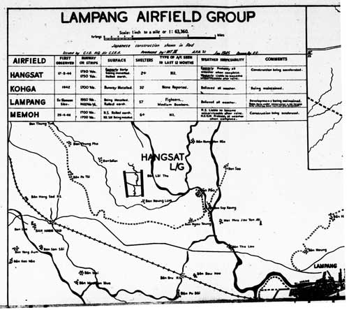
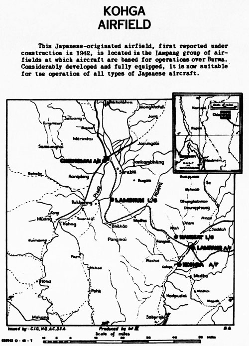
January 1945: The first map of the Lampang Airfield Group included this table:1

The entry above for “Kohga” reads:
| 1942 | |
| 1700 Yds | |
| Runway metalled | |
| 32 | |
| None reported | |
| Believed all weather | |
| Being maintained |
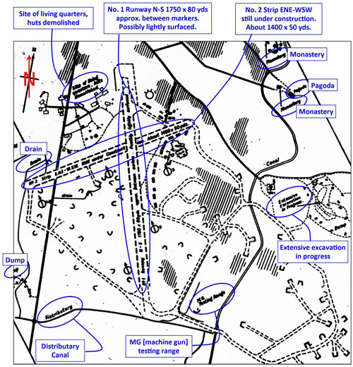
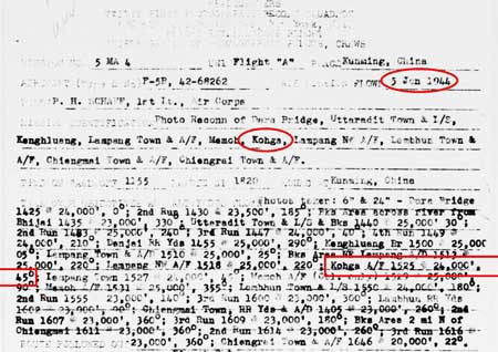
05 January 1945: Routine aerial photo report:2
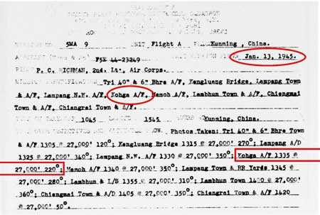
13 January 1945: Routine aerial photo report:3
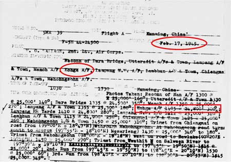
17 February 1945: Routine aerial photo report:4
This was the last order, at least to 21PRS, for aerial photos of Ko Kha, and the last mention of the air base in WWII files currently available.
Aftermath: the 1950s – 1980s5
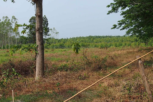
There was an excellent aerial photo of the sugar mill area dated 15 Jan 1954, which included much, but not all, of the airstrip; but it was unfortunately lost in the Burmese hack of 2Bangkok.com. The airstrip appeared not to have been used or maintained after the end of the war. There was an interesting detail to the southeast of the airstrip: six shelters were still visible, similar to the revetment seen in this extract from a 1944 aerial of Lampang airfield.6
The airstrip at Ko Kha does not appear on flight maps following the war (maps dated 1958, 1973, 1983).
11 September 1968: Air America recorded the runway as closed on this date. Details included:7
| 59 | |
| Ban Ko Kha | |
| NA 4412 | |
| NE 47-7 | |
| J-10-C | |
| N18°12′ E99°25′ | |
| 582 feet | |
| 5200 x ??? feet | |
| Sod / laterite | |
| [not listed] |
The lack of detail, particularly the runway headings, suggests that the runway had not been functional for some time prior to 1968.
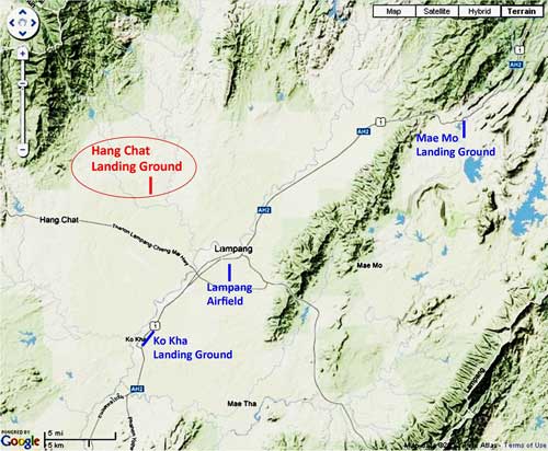
1971: USAF/GE Space Cmd AN/GPS-10 spacetrack radar was established here. A Google-based map locates its facilities at Ko Kha Air Station (Google Maps link) and provides some history.8 Note particularly that the Route 1 Bypass cutting through the air station site had already been built before the USAF arrived.
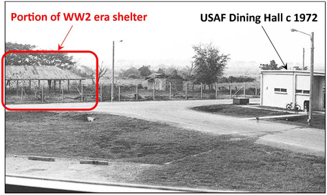
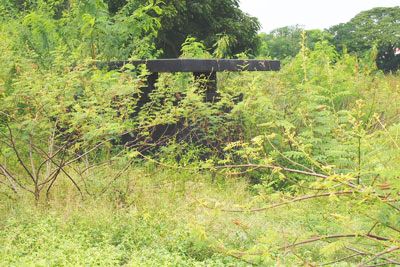
A sequence of photos of the USAF site taken from 1972 periodically up to the present by Ken Schmidt appears on flickr at Ko Kha Air Station, Thailand (offsite link). Of particular interest is one photo (offsite link) which confirms the existence of a structure shown on the Allied intel map sketch from 1943. The structure turns out to have been a roofed open-walled shelter (Google Maps link):9
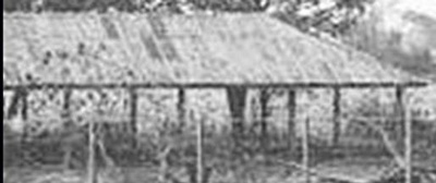
A closeup of the shelter:10
The location of the shelter is shown here in a current Google Earth view overlaid by the 1943 Allied intel sketch (shown with white lines):11
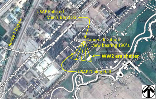
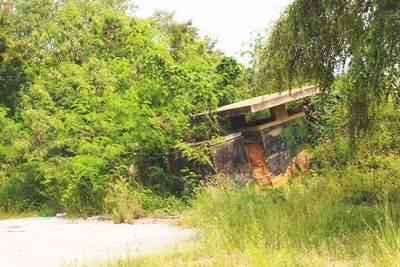
The structure scaled out on both the Allied intel sketch and aerial photo at roughly 30m x 12m. The spacing between roof supports wasn’t sufficient to allow an aircraft to use it as a hangar (rather than in roofed shelters, aircraft were typically housed within open revetments, though none appear in the 1943 sketch (however they did appear in the now-lost 1954 aerial photo). The original purpose for the shed is unknown.
1976: The USAF spacetrack radar station (Ko Kha) was closed.
Aftermath: today, on the ground
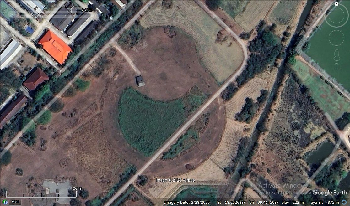
Ko Kha is a dynamic part of Thailand, and its landscape has been vastly altered since the war. Below the WW2 intel sketch of the air base from page 1 is superimposed as dashed white lines on a current Google Earth view of the area to show the approximate location of the old airstrip:12
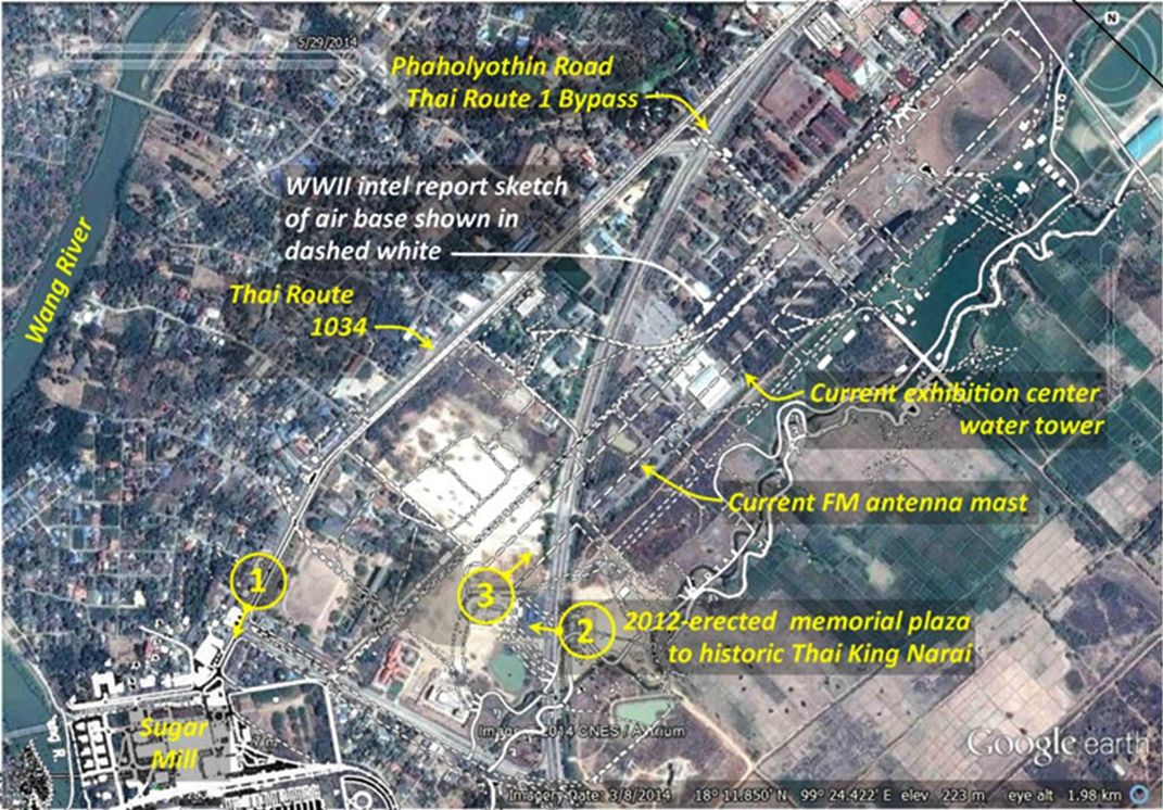
The circled numbers above provide reference for locations of the views which follow.
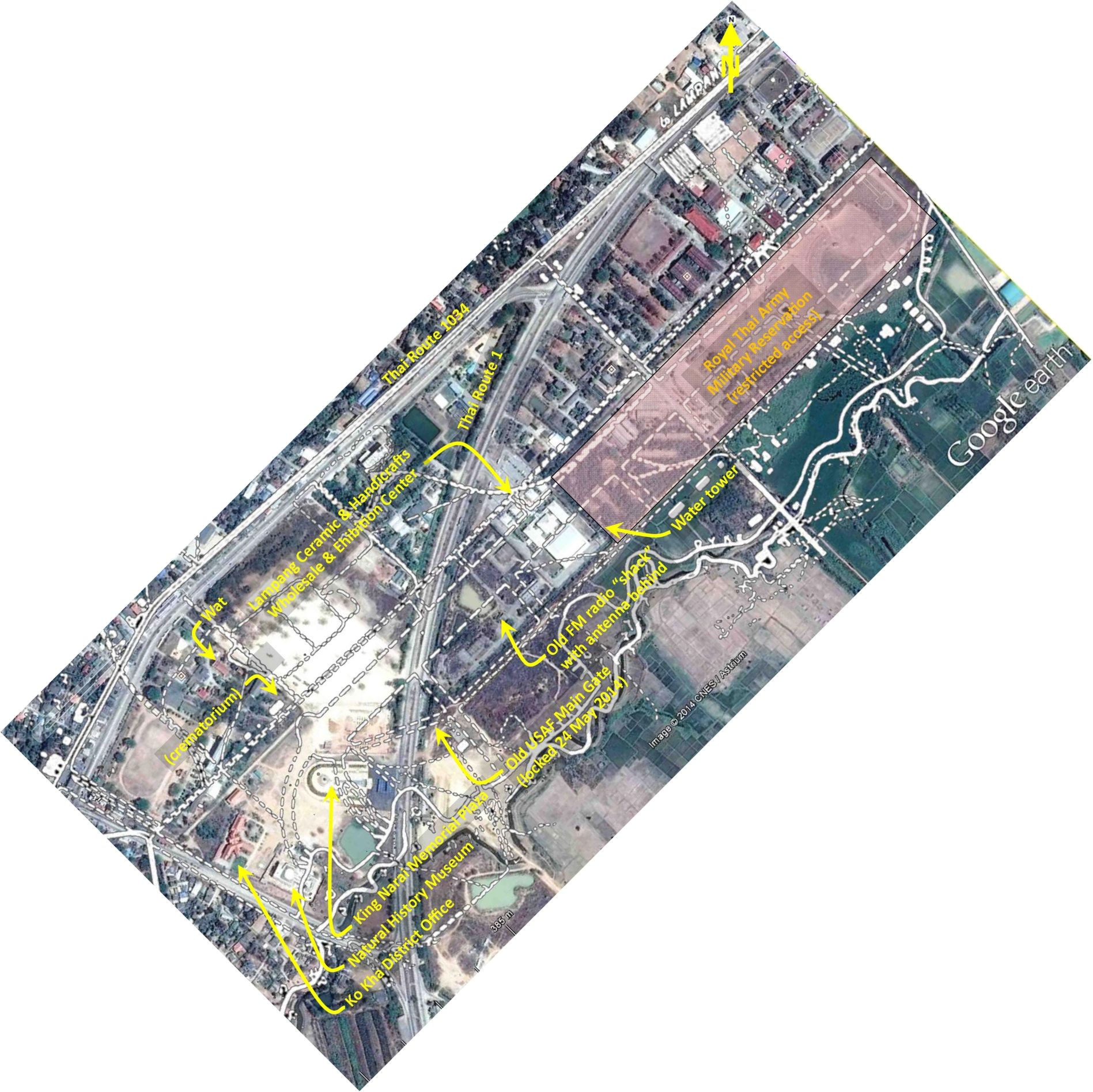
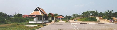
Here is a closer look at the air base / station site proper:13
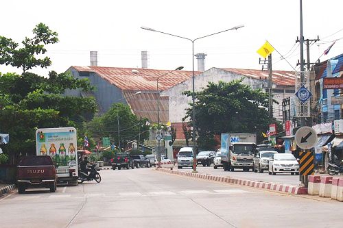
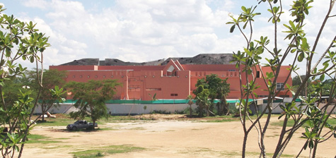
1. Looking SSWerly at the sugar factory from Thai Route 1034 at its
intersection with a highway accessing Thai Route 1:14
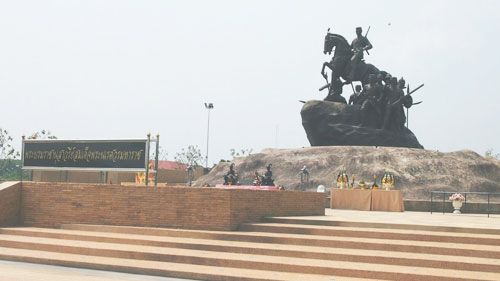
2. Looking westerly at the recently constructed monument to King Narai
from Thai Route 1. The monument proper is to the right:15
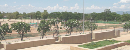
A closer look at the monument proper (looking southwesterly on the plaza):16
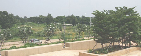
3. The south half of the old airstrip site has effectively been turned into an industrial park. The memorial, located at the original southwest end of the old runway (which may have been extended about 200 m further SW during the war), is the only part of the original site which is currently easily accessible. And it was from the memorial that the following photo was taken, looking northeast approximately along the center line of the old airstrip:17
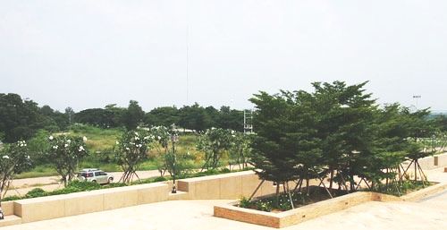
A closer view looking northeast up the airstrip center line and a bit more to the right:18
The antenna mast in the distance is approximately on the center line of the old airstrip. The water tower is closer in and just off the right edge of the old runway. The ladder‑like structure to the right is for a set of pole‑mounted power transformers along Thai Route 1.
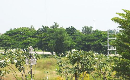
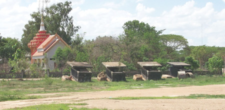
A drive around found only the perimeter roads for the industrial park as evidence of the old airstrip. The concrete structures pictured below are near the monument, but they are not pillboxes or guard shelters, but rather toilets for a public park from a later era:19
Post script (May 2014)20
The King Narai plaza monument was completed last year and photos above recorded its appearance in October 2013. Development at the south end of the site of the WW2 Ko Kha airstrip continues.
To the south of the plaza, a large building to house a natural history museum has been erected, to be opened in 2015:21
Looking northeasterly from the plaza along the alignment of the old runway, construction has started on a museum about King Narai, for whom the plaza is a monument.
October 2103: this photo is the same photo as above, but enhanced and cropped:22
May 2014: note that the grassy field between the monument and the treeline in the distance has been cleared and some foundations have been poured. Curiously, the trees in the planter at near right have been removed.23
The old, prefabricated reinforced concrete public restrooms shown above have been collected and relocated temporarily, possibly for reuse in the new facilities:24
Post script (May 2025) One apparent remaining function of the radar facility was clearly visible in Google Earth views of the site in 2013 and is still visible today: a circular 150m diameter “elephant ring” antenna (Google Maps link):
 akin to the 368m diameter wullenweber (offsite link) antenna (video tour of Ramasura) at Ramasura (offsite link) and southeast of Udon Thani (Google Maps link). The status of the Ko Kha installation is unclear; the latter was dismantled in 1975 “following base closure” (offsite link).
- Airfield Report No. 31, Feb 1945, “Lampang Airfield Group” (map) (extract), unnumbered page (USAF Archive microfilm reel A8056 p0003). Note that the table is dated January 1945 and is carried here chronologically as in that month; however, the table was actually published in the February edition of the Airfield Report.[↩]
- 21PRS Report Mission No. 5 MA 4, 05 Jan 1945 (USAF Archive microfilm reel A0878 p0815). Note that form is incorrectly dated with 1944, not 1945: the first digit of the report number 5 MA 4 confirms 1945. This is a typo that commonly occurs at the beginning of a new year.[↩]
- 21PRS Report Mission No. 5 MA 9, 13 Jan 1945 (USAF Archive microfilm reel A0878 p0807).[↩]
- 21PRS Report Mission No. 5 MA 39, 17 Feb 1945 (USAF Archive microfilm reel A0878 p0769).[↩]
- This section added 29 May 2014. Steve Druzak’s recollections from his visits as Commander, Detachment 2, 1985th Communications Squadron, at Don Muang to the US Air Force Station Detachment 1 at Ko Kha radar facility during the Vietnam War (various emails starting 1711 14 May 2014) stirred me into looking at the USAF presence at the site.[↩]
- Post added to 2bangkok forum “WW2 airfield Koh Kha, Lampang” by Wisarut Bholsithi on 26 Sep 2014 1219 hrs.[↩]
- Air Facilities Data Thailand 432, (?: Air America, 01 Feb 1971), p 20.[↩]
- A minor error there: the Wang River flows from Lampang, not to Lampang.[↩]
- Photo by Ken Schmidt, taken c1972, as shown in his flickr account: untitled photo (offsite link). A comment from Keith Hicks on the flickr page locates Ken Schmidt’s view as from the second floor of the Enlisted Men’s Barracks. Annotations by author using Microsoft Publisher.[↩]
- Ibid, extracted.[↩]
- Allied intel sketch, shown in white, overlaid on Google Earth view at N18°11.92 E99°24.66, using Microsoft Publisher. The USAF Enlisted Men’s Barracks and the Dining Hall, both labeled on the Google Earth view, appear indistinct because the buildings were long ago removed and what shows in the view are the foundations. The Google Earth view appears in lesser detail in the image directly below. Annotations by author using Microsoft Publisher.[↩]
- Google Earth view overlaid with earlier sketch annotated by author using Microsoft Publisher.[↩]
- Google Earth view overlaid with earlier sketch with north up-page, annotated by author using Microsoft Publisher.[↩]
- PA070874a.jpg 07 Oct 2013 by Jiraporn Jacqmin.[↩]
- PA070836b.jpg 07 Oct 2013 by Jiraporn Jacqmin.[↩]
- PA070854a.jpg 07 Oct 2013 by Jiraporn Jacqmin.[↩]
- PA070846a.jpg 07 Oct 2013 by Jiraporn Jacqmin.[↩]
- PA070847a.jpg 07 Oct 2013 by Jiraporn Jacqmin.[↩]
- A070863.jpg, A070864.jpg, 07 Oct 2013, by Jiraporn Jacqmin.[↩]
- This section added approx 15 May 2014.[↩]
- Extract from: DSCF2246.jpg 12 May 2014.[↩]
- Extract from: A070846.jpg 07 Oct 2013 by Jiraporn Jacqmin.[↩]
- Extract from DSCF2247.jpg 12 May 2014, by author.[↩]
- Extract from: DSCF2249.jpg 12 May 2014 by author.[↩]